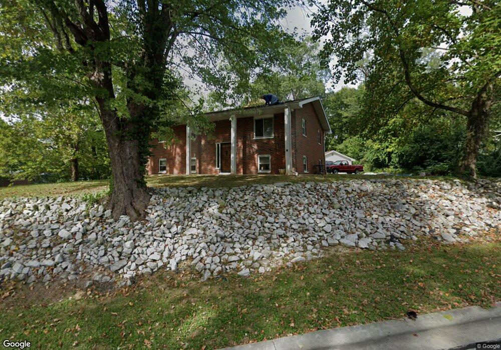
30 Pat Dr Collinsville, IL 62234
Estimated Value: $237,000 - $269,000
3
Beds
2
Baths
1,247
Sq Ft
$202/Sq Ft
Est. Value
About This Home
This home is located at 30 Pat Dr, Collinsville, IL 62234 and is currently estimated at $252,100, approximately $202 per square foot. 30 Pat Dr is a home located in Madison County with nearby schools including John A Renfro Elementary School, Dorris Intermediate School, and Collinsville Middle School.
Ownership History
Date
Name
Owned For
Owner Type
Purchase Details
Closed on
Apr 6, 2022
Sold by
Gibbs Bret S and Gibbs Jodie L
Bought by
Gibbs Bret S
Current Estimated Value
Home Financials for this Owner
Home Financials are based on the most recent Mortgage that was taken out on this home.
Original Mortgage
$52,500
Outstanding Balance
$48,693
Interest Rate
3.13%
Mortgage Type
New Conventional
Estimated Equity
$203,407
Create a Home Valuation Report for This Property
The Home Valuation Report is an in-depth analysis detailing your home's value as well as a comparison with similar homes in the area
Home Values in the Area
Average Home Value in this Area
Purchase History
| Date | Buyer | Sale Price | Title Company |
|---|---|---|---|
| Gibbs Bret S | -- | Abstracts & Titles |
Source: Public Records
Mortgage History
| Date | Status | Borrower | Loan Amount |
|---|---|---|---|
| Open | Gibbs Bret S | $52,500 |
Source: Public Records
Tax History
| Year | Tax Paid | Tax Assessment Tax Assessment Total Assessment is a certain percentage of the fair market value that is determined by local assessors to be the total taxable value of land and additions on the property. | Land | Improvement |
|---|---|---|---|---|
| 2024 | $3,841 | $79,150 | $12,170 | $66,980 |
| 2023 | $3,841 | $73,260 | $11,260 | $62,000 |
| 2022 | $4,287 | $67,740 | $10,410 | $57,330 |
| 2021 | $3,842 | $63,640 | $9,780 | $53,860 |
| 2020 | $3,690 | $60,490 | $9,290 | $51,200 |
| 2019 | $3,593 | $58,420 | $8,970 | $49,450 |
| 2018 | $3,518 | $55,340 | $8,500 | $46,840 |
| 2017 | $3,525 | $54,240 | $8,330 | $45,910 |
| 2016 | $4,042 | $58,290 | $9,980 | $48,310 |
| 2015 | $3,762 | $56,770 | $9,720 | $47,050 |
| 2014 | $3,762 | $56,770 | $9,720 | $47,050 |
| 2013 | $3,762 | $56,770 | $9,720 | $47,050 |
Source: Public Records
Map
Nearby Homes
- 6111 Tara Ln
- 625 W Country Ln
- 888 W Country Ln
- 2 Eastway Ct
- 204 Emery St
- 34 Belair Ct
- 102 3rd St
- 1029 Meadows Ct
- 1028 Meadows Ct
- 110 Linda Dr
- 127 Stonebridge Manor Dr
- 7132 W Main St
- 106 Bridle Ridge Rd
- 0 N Keebler Ave
- 40 Sugar Ln
- 1005 Daniel Dr
- 2 Chapel Ct
- 30 Saint Rose Dr
- 58 Stonebridge Crossing Dr
- 54 Stonebridge Crossing Dr
Your Personal Tour Guide
Ask me questions while you tour the home.