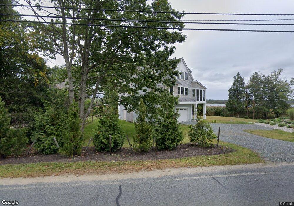
30 River Rd Westport, MA 02790
Acoaxet NeighborhoodEstimated Value: $1,245,299 - $1,927,000
3
Beds
--
Bath
2,289
Sq Ft
$652/Sq Ft
Est. Value
About This Home
This home is located at 30 River Rd, Westport, MA 02790 and is currently estimated at $1,491,325, approximately $651 per square foot. 30 River Rd is a home located in Bristol County with nearby schools including Alice A. Macomber Primary School, Westport Elementary School, and Westport Middle-High School.
Ownership History
Date
Name
Owned For
Owner Type
Purchase Details
Closed on
Nov 13, 2006
Sold by
Johnston Leon M and Kennedy Mary Louise
Bought by
Kennedy Mary Louise
Current Estimated Value
Create a Home Valuation Report for This Property
The Home Valuation Report is an in-depth analysis detailing your home's value as well as a comparison with similar homes in the area
Home Values in the Area
Average Home Value in this Area
Purchase History
| Date | Buyer | Sale Price | Title Company |
|---|---|---|---|
| Kennedy Mary Louise | -- | -- |
Source: Public Records
Mortgage History
| Date | Status | Borrower | Loan Amount |
|---|---|---|---|
| Previous Owner | Kennedy Mary Louise | $87,000 | |
| Previous Owner | Kennedy Mary Louise | $90,000 | |
| Previous Owner | Kennedy Mary Louise | $71,000 |
Source: Public Records
Tax History Compared to Growth
Tax History
| Year | Tax Paid | Tax Assessment Tax Assessment Total Assessment is a certain percentage of the fair market value that is determined by local assessors to be the total taxable value of land and additions on the property. | Land | Improvement |
|---|---|---|---|---|
| 2025 | $8,179 | $1,097,800 | $646,800 | $451,000 |
| 2024 | $7,606 | $984,000 | $601,900 | $382,100 |
| 2023 | $7,599 | $931,200 | $575,000 | $356,200 |
| 2022 | $7,244 | $889,400 | $575,000 | $314,400 |
| 2021 | $7,244 | $840,400 | $526,000 | $314,400 |
| 2020 | $6,920 | $820,900 | $506,500 | $314,400 |
| 2019 | $6,724 | $813,100 | $506,500 | $306,600 |
| 2018 | $6,376 | $780,400 | $513,100 | $267,300 |
| 2017 | $4,199 | $526,900 | $513,100 | $13,800 |
| 2016 | $5,554 | $702,100 | $513,100 | $189,000 |
| 2015 | $5,314 | $670,100 | $508,500 | $161,600 |
Source: Public Records
Map
Nearby Homes
- 17 Quail Trail
- 245 John Dyer Rd
- 116 Amy Hart Path
- 255 John Dyer Rd
- 1346 Main Rd Unit B
- 184 Field Stone Ln
- 19 Seabury Ln
- 90 Two Rod Rd
- 83 Long Hwy
- 505 Long Hwy
- 1580 Main Rd
- 101 Adamsville Rd
- 0 S Lake Rd Unit 73361665
- 0 S Lake Rd Unit 1382842
- 0 S Lake Rd Unit 1400795
- 0 Willow Ave
- 837 Main Road & Lot 2
- 837 Main Rd
- 1881 Main Rd
- 189 Brayton Point Rd
- 26 River Rd
- 19 River Rd
- 15 River Rd
- 112 Old Harbor Rd
- 18 River Rd
- 106 Old Harbor Rd
- 98 Old Harbor Rd
- 31 River Rd
- 25 River Rd
- 118 Old Harbor Rd
- 85 River Rd
- 14 River Rd
- Lot 23F Old Harbor Rd
- 86 River Rd
- 86 River Rd Unit 86
- 0 Lot 1 Old Harbor Rd Unit 1073856
- 131 Old Harbor Rd
- 69 Old Harbor Rd
- 87 River Rd
- 130 Old Harbor Rd