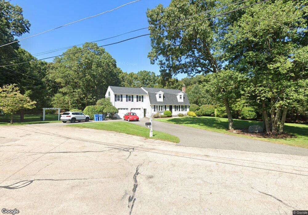
30 Warner Trail Rd Wrentham, MA 02093
Estimated Value: $763,213 - $904,000
3
Beds
2
Baths
2,451
Sq Ft
$334/Sq Ft
Est. Value
About This Home
This home is located at 30 Warner Trail Rd, Wrentham, MA 02093 and is currently estimated at $819,053, approximately $334 per square foot. 30 Warner Trail Rd is a home located in Norfolk County with nearby schools including Delaney Elementary School, Charles E Roderick, and Discovery Daycare Center.
Ownership History
Date
Name
Owned For
Owner Type
Purchase Details
Closed on
Apr 18, 2002
Sold by
Glassman Steven and Glassman Patricia A
Bought by
Abbott Brendan and Abbott Cheryl
Current Estimated Value
Home Financials for this Owner
Home Financials are based on the most recent Mortgage that was taken out on this home.
Original Mortgage
$296,000
Interest Rate
6.85%
Mortgage Type
Purchase Money Mortgage
Purchase Details
Closed on
Jun 25, 1992
Sold by
Thomas Joseph M and Thomas Carolyn L
Bought by
Glassman Steven and Glassman Patricia A
Create a Home Valuation Report for This Property
The Home Valuation Report is an in-depth analysis detailing your home's value as well as a comparison with similar homes in the area
Purchase History
| Date | Buyer | Sale Price | Title Company |
|---|---|---|---|
| Abbott Brendan | $370,000 | -- | |
| Glassman Steven | $182,600 | -- |
Source: Public Records
Mortgage History
| Date | Status | Borrower | Loan Amount |
|---|---|---|---|
| Open | Glassman Steven | $384,000 | |
| Closed | Abbott Brendan | $296,000 | |
| Previous Owner | Glassman Steven | $17,000 |
Source: Public Records
Tax History Compared to Growth
Tax History
| Year | Tax Paid | Tax Assessment Tax Assessment Total Assessment is a certain percentage of the fair market value that is determined by local assessors to be the total taxable value of land and additions on the property. | Land | Improvement |
|---|---|---|---|---|
| 2025 | $7,727 | $666,700 | $273,300 | $393,400 |
| 2024 | $7,375 | $614,600 | $273,300 | $341,300 |
| 2023 | $7,571 | $599,900 | $248,400 | $351,500 |
| 2022 | $7,158 | $523,600 | $223,500 | $300,100 |
| 2021 | $6,959 | $494,600 | $199,700 | $294,900 |
| 2020 | $7,010 | $491,900 | $182,200 | $309,700 |
| 2019 | $6,946 | $491,900 | $182,200 | $309,700 |
| 2018 | $6,458 | $453,500 | $182,400 | $271,100 |
| 2017 | $6,328 | $444,100 | $178,900 | $265,200 |
| 2016 | $6,019 | $421,500 | $173,700 | $247,800 |
| 2015 | $5,998 | $400,400 | $167,000 | $233,400 |
| 2014 | $6,040 | $394,500 | $160,600 | $233,900 |
Source: Public Records
Map
Nearby Homes
- 19 Nadeau Dr
- 155 Clark Rd Unit 155
- 483 Thurston St
- 319 Taunton St
- 1 Lorraine Metcalf Dr
- 10 Nature View Dr
- 15 Nature View Dr
- 11 Earle Stewart Ln
- 557 Dedham St
- 131 Creek St Unit 7
- Lot 1 - Blueberry 2 Car Plan at King Philip Estates
- Lot 8 - Blueberry 2 Car Plan at King Philip Estates
- Lot 5 - Hughes 2 car Plan at King Philip Estates
- Lot 6 - Blueberry 3 Car Plan at King Philip Estates
- 10 Earle Stewart Ln Unit Lot 5
- Lot 2 - Camden 2 Car Plan at King Philip Estates
- Lot 7 - Cedar Plan at King Philip Estates
- Lot 4 - Hemingway 2 Car Plan at King Philip Estates
- 14 Earle Stewart Ln
- Lot 3 - Blueberry 2 Car Plan at King Philip Estates
- 35 Warner Trail Rd
- 25 Warner Trail Rd
- 20 Warner Trail Rd
- 15 Warner Trail Rd
- 10 Warner Trail Rd
- 5 Warner Trail Rd
- 30 Lherault Dr
- 260 Cowell Rd
- 20 Lherault Dr
- 240 Cowell Rd
- 250 Cowell Rd
- 40 Lherault Dr
- 270 Cowell Rd
- 280 Cowell Rd
- 290 Cowell Rd
- 270 Cowell Rd Unit 270
- 198 Thurston St
- 184 Thurston St
- 210 Cowell Rd
- 230 Cowell Rd