Estimated Value: $669,600 - $884,000
4
Beds
2
Baths
2,425
Sq Ft
$337/Sq Ft
Est. Value
About This Home
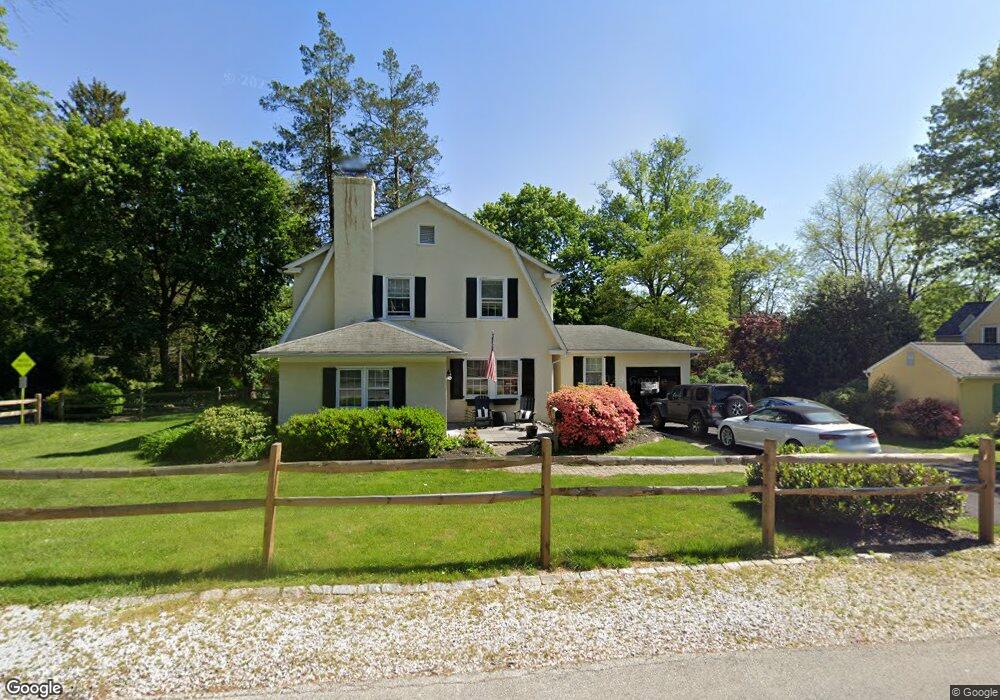
This home is located at 30 Wistar Rd, Paoli, PA 19301 and is currently estimated at $818,400, approximately $337 per square foot. 30 Wistar Rd is a home located in Chester County with nearby schools including General Wayne Elementary School, Great Valley Middle School, and Great Valley High School.
Ownership History
Date
Name
Owned For
Owner Type
Purchase Details
Closed on
Sep 16, 1997
Sold by
Benson Thomas and Benson Martha A
Bought by
Pettit Stephen J and Pettit Cynthia F
Current Estimated Value
Home Financials for this Owner
Home Financials are based on the most recent Mortgage that was taken out on this home.
Original Mortgage
$201,600
Interest Rate
7.14%
Purchase Details
Closed on
Dec 29, 1995
Sold by
The Rector Church Wardens & Vestrymen
Bought by
Benson Thomas and Benson Martha A
Home Financials for this Owner
Home Financials are based on the most recent Mortgage that was taken out on this home.
Original Mortgage
$121,400
Interest Rate
7.31%
Create a Home Valuation Report for This Property
The Home Valuation Report is an in-depth analysis detailing your home's value as well as a comparison with similar homes in the area
Home Values in the Area
Average Home Value in this Area
Purchase History
| Date | Buyer | Sale Price | Title Company |
|---|---|---|---|
| Pettit Stephen J | $212,300 | -- | |
| Benson Thomas | $161,750 | -- |
Source: Public Records
Mortgage History
| Date | Status | Borrower | Loan Amount |
|---|---|---|---|
| Previous Owner | Pettit Stephen J | $201,600 | |
| Previous Owner | Benson Thomas | $121,400 |
Source: Public Records
Tax History Compared to Growth
Tax History
| Year | Tax Paid | Tax Assessment Tax Assessment Total Assessment is a certain percentage of the fair market value that is determined by local assessors to be the total taxable value of land and additions on the property. | Land | Improvement |
|---|---|---|---|---|
| 2025 | $4,894 | $171,770 | $48,390 | $123,380 |
| 2024 | $4,894 | $171,770 | $48,390 | $123,380 |
| 2023 | $4,767 | $171,770 | $48,390 | $123,380 |
| 2022 | $4,671 | $171,770 | $48,390 | $123,380 |
| 2021 | $4,576 | $171,770 | $48,390 | $123,380 |
| 2020 | $4,500 | $171,770 | $48,390 | $123,380 |
| 2019 | $4,456 | $171,770 | $48,390 | $123,380 |
| 2018 | $4,371 | $171,770 | $48,390 | $123,380 |
| 2017 | $4,357 | $171,200 | $48,390 | $122,810 |
| 2016 | $3,814 | $171,200 | $48,390 | $122,810 |
| 2015 | $3,814 | $171,200 | $48,390 | $122,810 |
| 2014 | $3,814 | $171,200 | $48,390 | $122,810 |
Source: Public Records
Map
Nearby Homes
- 113 Manor Rd
- 106 S Valley Rd
- 21 Manor Rd
- 114 Manor Rd
- 28 Manor Rd
- 103 Fairview Rd
- 72 W Central Ave
- 38 E Circular Ave
- 313 W Central Ave
- 107 A W Central Ave
- 12 Summit Ave
- 9 Bryan Ave
- 3 Bryan Ave
- 131 Devon Rd
- 337 Paoli Woods
- 6 Lloyd Ave
- 2104 Weatherstone Dr Unit 2104
- 20 Rollingview Dr
- 1201 Weatherstone Dr Unit 1201
- 216 Paoli Pointe Dr Unit 216