

300 Apex Ave Banning, CA 92220
Estimated payment $10,171/month
Highlights
- 3.18 Acre Lot
- No HOA
- Bike Trail
- Property is near a park
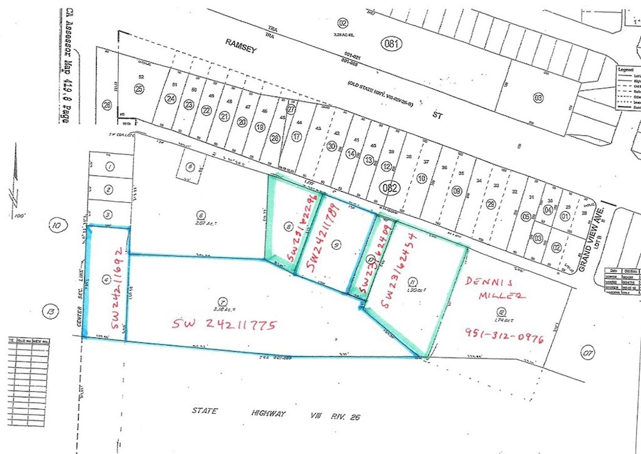
About This Lot
Property ready to develop. Auto mall, RV sales, Furniture and any commercial use. See other listings in area for a title of 10 acres of Interstate 10 freeway frontage property. See photo for parcel map showing available properties.
Listing Agent
Rise Realty Brokerage Email: larrysl@msn.com License #02123359 Listed on: 10/11/2024
Property Details
Property Type
- Land
Est. Annual Taxes
- $12,841
Lot Details
- 3.18 Acre Lot
- Density is 2-5 Units/Acre
- 419-090-004, 419-090-009
- Property is zoned CPS
Location
- Property is near a park
Utilities
- 220 Volts
- Phone Available
Listing and Financial Details
- Assessor Parcel Number 419090007
- $61 per year additional tax assessments
Community Details
Overview
- No Home Owners Association
Recreation
- Bike Trail
Map
Home Values in the Area
Average Home Value in this Area
Tax History
| Year | Tax Paid | Tax Assessment Tax Assessment Total Assessment is a certain percentage of the fair market value that is determined by local assessors to be the total taxable value of land and additions on the property. | Land | Improvement |
|---|---|---|---|---|
| 2025 | $12,841 | $1,005,114 | $1,005,114 | -- |
| 2023 | $12,890 | $966,085 | $966,085 | $0 |
| 2022 | $12,642 | $947,143 | $947,143 | $0 |
| 2021 | $12,399 | $928,572 | $928,572 | $0 |
| 2020 | $12,277 | $919,051 | $919,051 | $0 |
| 2019 | $12,085 | $901,031 | $901,031 | $0 |
| 2018 | $12,042 | $883,364 | $883,364 | $0 |
| 2017 | $11,857 | $866,044 | $866,044 | $0 |
| 2016 | $11,545 | $849,063 | $849,063 | $0 |
| 2015 | $11,353 | $836,310 | $836,310 | $0 |
| 2014 | $11,362 | $819,929 | $819,929 | $0 |
Property History
| Date | Event | Price | Change | Sq Ft Price |
|---|---|---|---|---|
| 03/01/2025 03/01/25 | Price Changed | $1,662,252 | 0.0% | -- |
| 10/11/2024 10/11/24 | For Sale | $1,662,240 | -- | -- |
Purchase History
| Date | Type | Sale Price | Title Company |
|---|---|---|---|
| Grant Deed | $1,070,000 | Commonwealth Land Title Co | |
| Corporate Deed | -- | -- | |
| Grant Deed | $40,000 | Northern Counties Title | |
| Grant Deed | $25,500 | Northern Counties Title | |
| Grant Deed | $25,000 | Northern Counties Title | |
| Grant Deed | $14,000 | Northern Counties Title | |
| Grant Deed | $12,000 | Northern Counties Title |
Source: California Regional Multiple Listing Service (CRMLS)
MLS Number: SW24211775
APN: 419-090-007
Disclaimer: Certain information contained herein is derived from information provided by parties other than Homes.com. All information provided is deemed reliable, but is not guaranteed to be accurate and should be independently verified.
![]() The multiple listing data appearing on this website, or contained in reports produced therefrom, is owned and copyrighted by California Regional Multiple Listing Service, Inc. ("CRMLS") and is protected by all applicable copyright laws. Information provided is for viewer's personal, non-commercial use and may not be used for any purpose other than to identify prospective properties the viewer may be interested in purchasing. All listing data, including but not limited to square footage and lot size is believed to be accurate, but the listing Agent, listing Broker and CRMLS and its affiliates do not warrant or guarantee such accuracy. The viewer should independently verify the listed data prior to making any decisions based on such information by personal inspection and/or contacting a real estate professional.
The multiple listing data appearing on this website, or contained in reports produced therefrom, is owned and copyrighted by California Regional Multiple Listing Service, Inc. ("CRMLS") and is protected by all applicable copyright laws. Information provided is for viewer's personal, non-commercial use and may not be used for any purpose other than to identify prospective properties the viewer may be interested in purchasing. All listing data, including but not limited to square footage and lot size is believed to be accurate, but the listing Agent, listing Broker and CRMLS and its affiliates do not warrant or guarantee such accuracy. The viewer should independently verify the listed data prior to making any decisions based on such information by personal inspection and/or contacting a real estate professional.
Based on information from California Regional Multiple Listing Service, Inc. and /or other sources. All data, including all measurements and calculations of area, is obtained from various sources and has not been, and will not be, verified by broker or MLS. All information should be independently reviewed and verified for accuracy. Properties may or may not be listed by the office/agent presenting the information
- 5700 W Wilson St Unit 3
- 5700 W Wilson St Unit 42
- 5700 W Wilson St Unit 86
- 5700 W Wilson St Unit 99
- 5700 W Wilson St Unit 102
- 5700 W Wilson St Unit 25
- 178 Janan Ct
- 298 Apex Ave
- 204 Beverly Dr
- 234 Beverly Dr
- 5302 C St
- 5238 Spring View Dr
- 178 Clair Ct
- 916 Aloe Way
- 5242 C St
- 5908 Raven Way
- 98 Lori Way
- 5388 C St
- 5366 C St
- 5388 Echo Dr
- 5001-5099 W Wilson St
- 5168 W Pinehurst Dr
- 36 Cold Spring Ave
- 170 Potter Creek
- 1643 Beaver Creek
- 2141 Birdie Dr
- 1585 Park Haven Dr
- 726 Chestnut Ave
- 1248 Massachusetts Ave
- 2890 Summer Set Cir
- 1473 Peters Canyon
- 142 Diego Rd
- 174 Maple Ave
- 835 Brownie Way
- 15135 Del Rita Rd
- 1145 Orange Ave
- 1664 Milford Way
- 35286 Sorenstam Dr Unit A
- 315 N 12th St
- 10433 Overland Trail
