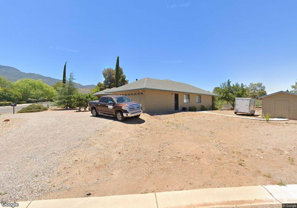
300 Black Hills Dr Clarkdale, AZ 86324
Estimated Value: $433,980 - $519,000
--
Bed
--
Bath
1,715
Sq Ft
$280/Sq Ft
Est. Value
About This Home
This home is located at 300 Black Hills Dr, Clarkdale, AZ 86324 and is currently estimated at $479,995, approximately $279 per square foot. 300 Black Hills Dr is a home located in Yavapai County with nearby schools including Cottonwood Elementary School, Dr Daniel Bright Elementary School, and Cottonwood Community School.
Ownership History
Date
Name
Owned For
Owner Type
Purchase Details
Closed on
Jul 20, 2020
Sold by
Williams Melissa and Ashkenazi Amichay
Bought by
Ashkenazi Amichay and Williams Melissa
Current Estimated Value
Home Financials for this Owner
Home Financials are based on the most recent Mortgage that was taken out on this home.
Original Mortgage
$230,000
Outstanding Balance
$203,949
Interest Rate
3.1%
Mortgage Type
New Conventional
Estimated Equity
$276,046
Purchase Details
Closed on
Dec 10, 2013
Sold by
Stearley Robert D and Stearley Loretta O
Bought by
Stearley Robert D and Stearley Denise
Purchase Details
Closed on
Sep 4, 2012
Sold by
Stearley Robert D
Bought by
Stearley Robert D and Stearley Loretta O
Purchase Details
Closed on
Mar 17, 1994
Sold by
Blake Wesley A and Blake Nathalie E
Bought by
Blake Wesley A and Blake Nathalie E
Create a Home Valuation Report for This Property
The Home Valuation Report is an in-depth analysis detailing your home's value as well as a comparison with similar homes in the area
Home Values in the Area
Average Home Value in this Area
Purchase History
| Date | Buyer | Sale Price | Title Company |
|---|---|---|---|
| Ashkenazi Amichay | -- | Yavapai Title | |
| Ashkenazi Amichay | $330,000 | Yavapai Title | |
| Stearley Robert D | $148,000 | None Available | |
| Stearley Robert D | $111,000 | Yavapai Title Agency Inc | |
| Blake Wesley A | -- | -- |
Source: Public Records
Mortgage History
| Date | Status | Borrower | Loan Amount |
|---|---|---|---|
| Open | Ashkenazi Amichay | $230,000 |
Source: Public Records
Tax History Compared to Growth
Tax History
| Year | Tax Paid | Tax Assessment Tax Assessment Total Assessment is a certain percentage of the fair market value that is determined by local assessors to be the total taxable value of land and additions on the property. | Land | Improvement |
|---|---|---|---|---|
| 2026 | $2,308 | $31,990 | -- | -- |
| 2024 | $2,194 | $31,035 | -- | -- |
| 2023 | $2,229 | $24,594 | $6,133 | $18,461 |
| 2022 | $2,194 | $21,194 | $4,935 | $16,259 |
| 2021 | $2,276 | $19,678 | $4,946 | $14,732 |
| 2020 | $2,235 | $0 | $0 | $0 |
| 2019 | $2,193 | $0 | $0 | $0 |
| 2018 | $2,106 | $0 | $0 | $0 |
| 2017 | $2,016 | $0 | $0 | $0 |
| 2016 | $1,969 | $0 | $0 | $0 |
| 2015 | -- | $0 | $0 | $0 |
| 2014 | -- | $0 | $0 | $0 |
Source: Public Records
Map
Nearby Homes
- 1830 W Trail Blazer Dr
- 2101 Canyon Dr
- 1910 W Trail Blazer Dr
- 1869 W Trail Blazer Dr
- 240 Rogers Place
- 421 Casner Dr
- 222 Rogers Place
- 235 S Cowboy Way
- 1941 Crossroads Blvd
- 1985 Roadrunner Ct
- 1660 W Bronco Ln
- 293 S Wild Horse Way
- 265 S Latigo Way
- Xxxx Xxxx --
- 240 S Maverick Way
- 1850 W Wagon Wheel Rd
- 338 S Wild Horse Way
- 1865 W Wagon Wheel Rd
- 15 Alamos Dr Unit A & B
- 621 Skyline Blvd Unit 48