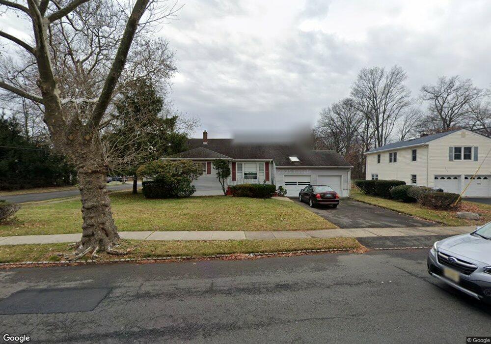
300 Milltown Rd Springfield, NJ 07081
Estimated Value: $698,000 - $767,000
Studio
--
Bath
2,401
Sq Ft
$305/Sq Ft
Est. Value
About This Home
This home is located at 300 Milltown Rd, Springfield, NJ 07081 and is currently estimated at $732,857, approximately $305 per square foot. 300 Milltown Rd is a home located in Union County with nearby schools including Jonathan Dayton High School and St James The Apostle School.
Ownership History
Date
Name
Owned For
Owner Type
Purchase Details
Closed on
Jun 26, 2025
Sold by
Bernstein Peggy
Bought by
Piagari Arlene
Current Estimated Value
Purchase Details
Closed on
Jun 4, 2025
Sold by
Otoole Ashley and Otoole John
Bought by
Piagari Arlene
Purchase Details
Closed on
Nov 30, 2018
Sold by
Bernstein Peggy and Estate Of Thomas Otoole
Bought by
Bernstein Peggy and Piagari Arlene
Purchase Details
Closed on
Nov 12, 2018
Sold by
Bernstien Peggy and Estate Of Ohn Otoole
Bought by
Berstein Peggy and Piagari Arlene
Purchase Details
Closed on
Jul 1, 1987
Bought by
O'Toole John Estate Of
Create a Home Valuation Report for This Property
The Home Valuation Report is an in-depth analysis detailing your home's value as well as a comparison with similar homes in the area
Home Values in the Area
Average Home Value in this Area
Purchase History
| Date | Buyer | Sale Price | Title Company |
|---|---|---|---|
| Piagari Arlene | $220,000 | Evident Title | |
| Piagari Arlene | $220,000 | Evident Title | |
| Piagari Arlene | $225,000 | Evident Title | |
| Piagari Arlene | $225,000 | Evident Title | |
| Bernstein Peggy | -- | None Available | |
| Berstein Peggy | -- | None Available | |
| O'Toole John Estate Of | $230,000 | -- |
Source: Public Records
Tax History
| Year | Tax Paid | Tax Assessment Tax Assessment Total Assessment is a certain percentage of the fair market value that is determined by local assessors to be the total taxable value of land and additions on the property. | Land | Improvement |
|---|---|---|---|---|
| 2025 | $14,649 | $616,800 | $232,200 | $384,600 |
| 2024 | $14,408 | $616,800 | $232,200 | $384,600 |
| 2023 | $14,408 | $616,800 | $232,200 | $384,600 |
| 2022 | $13,378 | $616,800 | $232,200 | $384,600 |
| 2021 | $14,175 | $190,400 | $67,600 | $122,800 |
| 2020 | $13,954 | $190,400 | $67,600 | $122,800 |
| 2019 | $13,766 | $190,400 | $67,600 | $122,800 |
| 2018 | $13,518 | $190,400 | $67,600 | $122,800 |
| 2017 | $13,147 | $190,400 | $67,600 | $122,800 |
| 2016 | $12,892 | $190,400 | $67,600 | $122,800 |
| 2015 | $12,742 | $190,400 | $67,600 | $122,800 |
| 2014 | $12,502 | $190,400 | $67,600 | $122,800 |
Source: Public Records
Map
Nearby Homes
- 20 Archbridge Ln
- 13 Evergreen Ave
- 559 S Springfield Ave Unit 559
- 148 Locust Dr
- 23 Diven St
- 294 Mountain Ave
- 238 Riverside Dr
- 750 Andover Rd
- 2705 Andrea Rd
- 798 Pinewood Rd
- 105 Battle Hill Ave
- 787 Liberty Ave
- 67 Battle Hill Ave
- 2469 Macarthur Dr
- 2670 Bancroft Ave
- 701 Mountain Ave
- 24 Brook St
- 960 Moessner Ave
- 2442 Terrill Rd
- 35 S Derby Rd
Your Personal Tour Guide
Ask me questions while you tour the home.