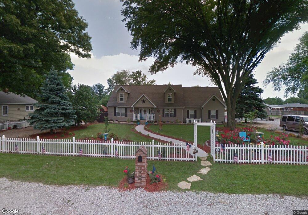
300 Roosevelt Ave Wood River, IL 62095
Estimated Value: $199,000 - $222,000
3
Beds
3
Baths
2,639
Sq Ft
$81/Sq Ft
Est. Value
About This Home
This home is located at 300 Roosevelt Ave, Wood River, IL 62095 and is currently estimated at $212,796, approximately $80 per square foot. 300 Roosevelt Ave is a home located in Madison County with nearby schools including Eastwood Elementary School, East Alton Middle School, and East Alton-Wood River High School.
Ownership History
Date
Name
Owned For
Owner Type
Purchase Details
Closed on
May 16, 2011
Sold by
Federal National Mortgage Association
Bought by
Murphy Jimmie B
Current Estimated Value
Home Financials for this Owner
Home Financials are based on the most recent Mortgage that was taken out on this home.
Original Mortgage
$112,084
Outstanding Balance
$77,606
Interest Rate
4.8%
Mortgage Type
FHA
Estimated Equity
$135,190
Purchase Details
Closed on
Dec 15, 2010
Sold by
Robinson Elizabeth M
Bought by
Federal National Mortgage Association
Create a Home Valuation Report for This Property
The Home Valuation Report is an in-depth analysis detailing your home's value as well as a comparison with similar homes in the area
Home Values in the Area
Average Home Value in this Area
Purchase History
| Date | Buyer | Sale Price | Title Company |
|---|---|---|---|
| Murphy Jimmie B | $115,000 | None Available | |
| Federal National Mortgage Association | -- | None Available |
Source: Public Records
Mortgage History
| Date | Status | Borrower | Loan Amount |
|---|---|---|---|
| Open | Murphy Jimmie B | $112,084 |
Source: Public Records
Tax History Compared to Growth
Tax History
| Year | Tax Paid | Tax Assessment Tax Assessment Total Assessment is a certain percentage of the fair market value that is determined by local assessors to be the total taxable value of land and additions on the property. | Land | Improvement |
|---|---|---|---|---|
| 2024 | $4,120 | $49,990 | $7,700 | $42,290 |
| 2023 | $4,120 | $46,600 | $7,180 | $39,420 |
| 2022 | $3,857 | $43,010 | $6,630 | $36,380 |
| 2021 | $3,582 | $40,090 | $6,180 | $33,910 |
| 2020 | $3,478 | $38,610 | $5,950 | $32,660 |
| 2019 | $3,384 | $37,460 | $5,770 | $31,690 |
| 2018 | $3,295 | $35,590 | $5,480 | $30,110 |
| 2017 | $3,123 | $34,740 | $5,350 | $29,390 |
| 2016 | $3,160 | $34,740 | $5,350 | $29,390 |
| 2015 | $3,146 | $34,370 | $5,290 | $29,080 |
| 2014 | $3,146 | $34,370 | $5,290 | $29,080 |
| 2013 | $3,146 | $34,870 | $5,370 | $29,500 |
Source: Public Records
Map
Nearby Homes
- 959 Cedar Dr
- 523 Wilson Ave
- 345 Illinois Ave
- 104 Whitelaw Ave
- 121 Whitelaw Ave
- 98 Wood River Ave
- 641 Leslie Ave
- 830 N Wood River Ave
- 777 Condit St
- 283 Hi Pointe Place
- 782 Berry Rd
- 565 5th St
- 537 Tipton Ave
- 529 5th St
- 833 State St
- 250 Hi Pointe Place
- 726 Rice St
- 133 Lincoln Ave
- 469 N 1st St
- 458 N 6th St
- 316 Roosevelt Ave
- 309 Pershing Ave
- 301 Pershing Ave
- 315 Pershing Ave
- 303 Roosevelt Ave
- 955 Cedar Dr
- 323 Pershing Ave
- 951 Cedar Dr
- 324 Roosevelt Ave
- 319 Roosevelt Ave
- 329 Pershing Ave
- 963 Cedar Dr
- 947 Cedar Dr
- 337 Pershing Ave
- 967 Cedar Dr
- 943 Cedar Dr
- 323 Roosevelt Ave
- 337 Roosevelt Ave
- 344 Roosevelt Ave
- 939 Cedar Dr