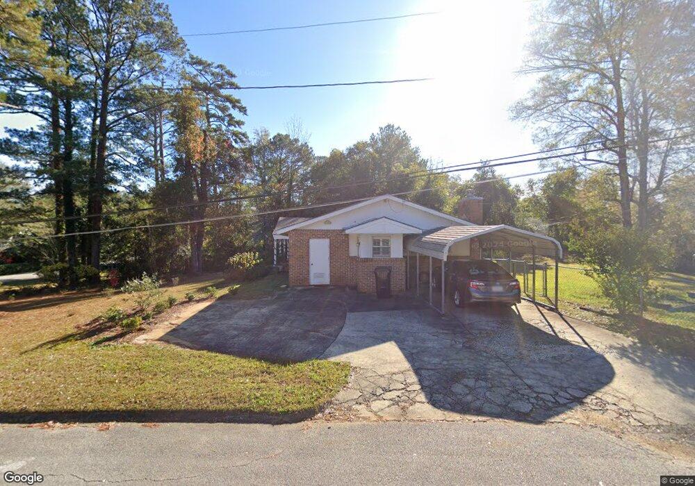
300 Sheppard St West Point, GA 31833
Estimated Value: $191,679 - $327,000
3
Beds
3
Baths
2,088
Sq Ft
$125/Sq Ft
Est. Value
About This Home
This home is located at 300 Sheppard St, West Point, GA 31833 and is currently estimated at $261,670, approximately $125 per square foot. 300 Sheppard St is a home located in Troup County with nearby schools including West Point Elementary School, Long Cane Elementary School, and Berta Weathersbee Elementary School.
Ownership History
Date
Name
Owned For
Owner Type
Purchase Details
Closed on
Apr 14, 2023
Sold by
Bishop Of Birmingham In Alabama
Bought by
Holy Family Catholic Parish Lanett
Current Estimated Value
Purchase Details
Closed on
Nov 24, 2014
Sold by
Krause Duncan C
Bought by
Most Robert J and Most Baker B
Purchase Details
Closed on
Oct 1, 2004
Sold by
Krause Bettine J
Bought by
The Bettine J Krause Family
Purchase Details
Closed on
Jan 1, 1967
Bought by
Krause Bettine J
Create a Home Valuation Report for This Property
The Home Valuation Report is an in-depth analysis detailing your home's value as well as a comparison with similar homes in the area
Home Values in the Area
Average Home Value in this Area
Purchase History
| Date | Buyer | Sale Price | Title Company |
|---|---|---|---|
| Holy Family Catholic Parish Lanett | -- | -- | |
| Most Robert J | -- | -- | |
| The Bettine J Krause Family | -- | -- | |
| Krause Bettine J | -- | -- |
Source: Public Records
Tax History Compared to Growth
Tax History
| Year | Tax Paid | Tax Assessment Tax Assessment Total Assessment is a certain percentage of the fair market value that is determined by local assessors to be the total taxable value of land and additions on the property. | Land | Improvement |
|---|---|---|---|---|
| 2024 | -- | $58,548 | $5,840 | $52,708 |
| 2023 | $0 | $56,304 | $5,840 | $50,464 |
| 2022 | $2,094 | $53,504 | $5,840 | $47,664 |
| 2021 | $2,035 | $52,008 | $5,840 | $46,168 |
| 2020 | $2,050 | $52,008 | $5,840 | $46,168 |
| 2019 | $2,017 | $51,160 | $5,836 | $45,324 |
| 2018 | $0 | $48,988 | $5,836 | $43,152 |
| 2017 | $0 | $48,988 | $5,836 | $43,152 |
| 2016 | $876 | $29,050 | $5,836 | $23,214 |
| 2015 | $878 | $29,050 | $5,836 | $23,214 |
| 2014 | $842 | $27,829 | $5,836 | $21,993 |
| 2013 | -- | $29,422 | $5,836 | $23,586 |
Source: Public Records
Map
Nearby Homes
- 1903 Ridgewood Dr
- 508 Pine St
- 1505 Wisteria Dr
- 0 Ga Highway 0116 Unit 10619139
- 1599 Highway 29
- 1008 E 12th St
- 1410 Roper Ave
- 0 Sunset Dr Unit 10451831
- 1314 4th Ave
- 713 Avenue H
- 0 Arrowhead Dr Unit 10451860
- 1007 4th Ave
- 804 E 6th St
- 509 Cleveland St
- 712 4th Ave
- 1508 N 4th Ave
- 311 E 4th St
- 4517 Georgia 18
- 4509 Georgia 18
- 4523 Georgia 18
- 1702 Rosemont Ave
- 1705 Malco Dr
- 1703 Malco Dr
- 200 Sheppard St
- 1705 Rosemont Ave
- 201 Sheppard St
- 1801 Malco Dr
- 1703 Rosemont Ave
- 1701 Malco Dr
- 1702 Malco Dr
- 1704 Malco Dr
- 401 Sheppard St
- 200 Rabern St
- 1803 Malco Dr
- 1801 Ridgewood Dr
- 1800 Malco Dr
- 404 Sheppard St
- 1700 Malco Dr
- 202 Rabern St
- 403 Sheppard St