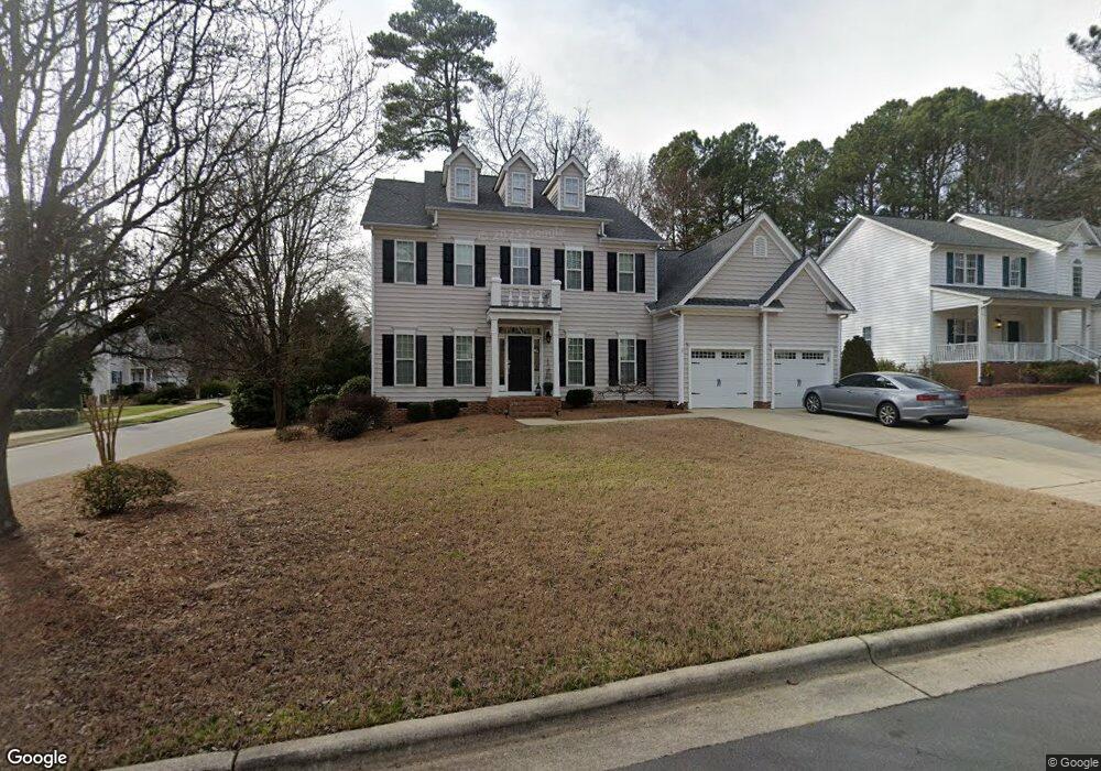
300 Sir Brennan Ct Apex, NC 27523
West Cary NeighborhoodEstimated Value: $783,000 - $866,000
5
Beds
4
Baths
3,480
Sq Ft
$235/Sq Ft
Est. Value
About This Home
This home is located at 300 Sir Brennan Ct, Apex, NC 27523 and is currently estimated at $817,199, approximately $234 per square foot. 300 Sir Brennan Ct is a home located in Wake County with nearby schools including Salem Elementary, Salem Middle, and Green Hope High.
Ownership History
Date
Name
Owned For
Owner Type
Purchase Details
Closed on
Jan 17, 2002
Sold by
Joseph John K and Joseph Rose M
Bought by
Lackey Shawn and Lackey Diana
Current Estimated Value
Home Financials for this Owner
Home Financials are based on the most recent Mortgage that was taken out on this home.
Original Mortgage
$228,000
Interest Rate
6.21%
Purchase Details
Closed on
Dec 15, 1999
Sold by
New Fortis Corporation The
Bought by
Joseph John K and Joseph Rose M
Home Financials for this Owner
Home Financials are based on the most recent Mortgage that was taken out on this home.
Original Mortgage
$250,200
Interest Rate
6.5%
Create a Home Valuation Report for This Property
The Home Valuation Report is an in-depth analysis detailing your home's value as well as a comparison with similar homes in the area
Home Values in the Area
Average Home Value in this Area
Purchase History
| Date | Buyer | Sale Price | Title Company |
|---|---|---|---|
| Lackey Shawn | $285,000 | -- | |
| Joseph John K | $313,000 | -- |
Source: Public Records
Mortgage History
| Date | Status | Borrower | Loan Amount |
|---|---|---|---|
| Previous Owner | Lackey Shawn | $228,000 | |
| Previous Owner | Joseph John K | $250,200 |
Source: Public Records
Tax History Compared to Growth
Tax History
| Year | Tax Paid | Tax Assessment Tax Assessment Total Assessment is a certain percentage of the fair market value that is determined by local assessors to be the total taxable value of land and additions on the property. | Land | Improvement |
|---|---|---|---|---|
| 2025 | $6,368 | $727,045 | $215,000 | $512,045 |
| 2024 | $6,225 | $727,045 | $215,000 | $512,045 |
| 2023 | $5,219 | $473,958 | $78,000 | $395,958 |
| 2022 | $4,899 | $473,958 | $78,000 | $395,958 |
| 2021 | $4,712 | $473,958 | $78,000 | $395,958 |
| 2020 | $4,665 | $473,958 | $78,000 | $395,958 |
| 2019 | $4,463 | $391,230 | $78,000 | $313,230 |
| 2018 | $4,204 | $391,230 | $78,000 | $313,230 |
| 2017 | $3,913 | $391,230 | $78,000 | $313,230 |
| 2016 | $3,856 | $391,230 | $78,000 | $313,230 |
| 2015 | $3,944 | $390,655 | $78,000 | $312,655 |
| 2014 | $3,802 | $390,655 | $78,000 | $312,655 |
Source: Public Records
Map
Nearby Homes
- 320 Sutton Glen Dr
- 2021 Patapsco Dr
- 106 Daleshire Dr
- 100 Wentbridge Rd
- 105 Catchpenny Ct
- 114 Calebra Way
- 120 Union Mills Way
- 103 Town Creek Dr
- 1808 Beaudet Ln
- 538 Rowanwood Way
- 552 Rowanwood Way
- 146 Swan Quarter Dr
- 712 Oak Ridge Dr
- 700 Oak Ridge Dr
- 721 Oak Ridge Dr
- 708 Oak Ridge Dr
- 705 Oak Ridge Dr
- 720 Oak Ridge Dr
- 6716 Valley Woods Ln
- 713 Oak Ridge Dr
- 302 Sir Brennan Ct
- 101 Hoboken Ct
- 103 Hoboken Ct
- 301 Hasbrouck Dr
- 304 Sir Brennan Ct
- 207 Hasbrouck Dr
- 301 Sir Brennan Ct
- 303 Hasbrouck Dr
- 303 Sir Brennan Ct
- 105 Hoboken Ct
- 205 Hasbrouck Dr
- 305 Sir Brennan Ct
- 305 Hasbrouck Dr
- 306 Sir Brennan Ct
- 203 Hasbrouck Dr
- 200 Jerryanne Ct
- 200 Jennyanne Ct
- 1051 Holtridge Dr
- 107 Hoboken Ct
- 100 Hoboken Ct