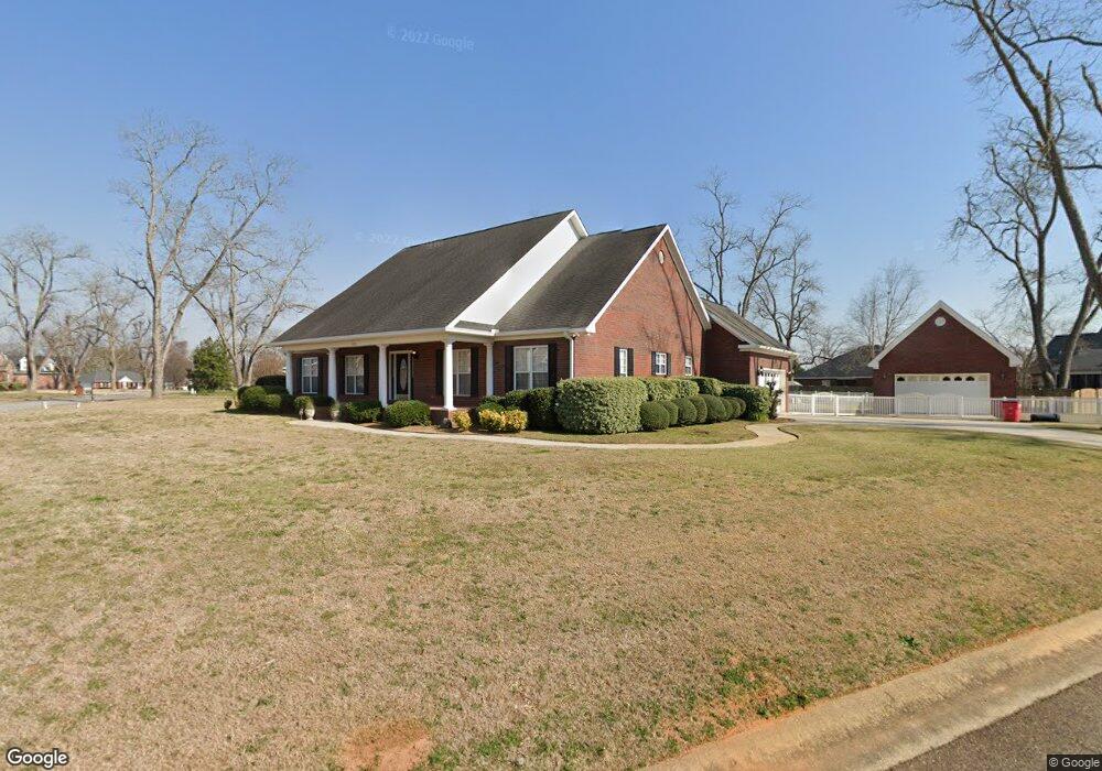
300 Whittington Dr Macon, GA 31216
Estimated Value: $319,109 - $408,000
3
Beds
4
Baths
2,485
Sq Ft
$145/Sq Ft
Est. Value
About This Home
This home is located at 300 Whittington Dr, Macon, GA 31216 and is currently estimated at $359,527, approximately $144 per square foot. 300 Whittington Dr is a home located in Bibb County with nearby schools including Heard Elementary School, Rutland Middle School, and Rutland High School.
Ownership History
Date
Name
Owned For
Owner Type
Purchase Details
Closed on
Sep 15, 2006
Sold by
Johnson William M
Bought by
Jones Charles E and Jones Mary J
Current Estimated Value
Home Financials for this Owner
Home Financials are based on the most recent Mortgage that was taken out on this home.
Original Mortgage
$245,000
Outstanding Balance
$145,650
Interest Rate
6.58%
Mortgage Type
New Conventional
Estimated Equity
$213,877
Purchase Details
Closed on
Jul 8, 2004
Purchase Details
Closed on
Apr 24, 2001
Bought by
Jones Charles E and Jones Mary J
Purchase Details
Closed on
Apr 28, 1999
Create a Home Valuation Report for This Property
The Home Valuation Report is an in-depth analysis detailing your home's value as well as a comparison with similar homes in the area
Home Values in the Area
Average Home Value in this Area
Purchase History
| Date | Buyer | Sale Price | Title Company |
|---|---|---|---|
| Jones Charles E | $245,000 | None Avilebel | |
| -- | $235,000 | -- | |
| Jones Charles E | $200,000 | -- | |
| -- | $23,900 | -- |
Source: Public Records
Mortgage History
| Date | Status | Borrower | Loan Amount |
|---|---|---|---|
| Open | Jones Charles E | $245,000 |
Source: Public Records
Tax History Compared to Growth
Tax History
| Year | Tax Paid | Tax Assessment Tax Assessment Total Assessment is a certain percentage of the fair market value that is determined by local assessors to be the total taxable value of land and additions on the property. | Land | Improvement |
|---|---|---|---|---|
| 2025 | $3,064 | $131,696 | $18,000 | $113,696 |
| 2024 | $2,894 | $120,959 | $18,000 | $102,959 |
| 2023 | $2,437 | $120,959 | $18,000 | $102,959 |
| 2022 | $3,542 | $109,309 | $15,960 | $93,349 |
| 2021 | $3,137 | $89,554 | $12,600 | $76,954 |
| 2020 | $3,205 | $89,554 | $12,600 | $76,954 |
| 2019 | $2,960 | $82,612 | $12,600 | $70,012 |
| 2018 | $4,713 | $82,612 | $12,600 | $70,012 |
| 2017 | $2,659 | $77,969 | $12,600 | $65,369 |
| 2016 | $2,455 | $77,969 | $12,600 | $65,369 |
| 2015 | $3,476 | $77,969 | $12,600 | $65,369 |
| 2014 | $4,500 | $98,738 | $15,120 | $83,618 |
Source: Public Records
Map
Nearby Homes
- 436 Joseph Chandler Dr
- 411 Bob White Rd
- 428 Bob White Rd
- 465 Bob White Rd
- 708 Coopers Lnd
- 408 Resting Fawn Place
- DUPONT Plan at Quail Ridge
- GARDNER Plan at Quail Ridge
- KINGSTON Plan at Quail Ridge
- ESSEX Plan at Quail Ridge
- 102 Haylie Ct
- 104 Alayna Ct
- 330 Cody Dr
- 813 Ocala National Trail
- 328 Cody Dr
- Jodeco Plan at Goodall Woods
- Sierra Plan at Goodall Woods
- Poplar Plan at Goodall Woods
- Russell Plan at Goodall Woods
- Clayton Plan at Goodall Woods
- 304 Whittington Dr
- 296 Whittington Ct
- 411 Hardwick Dr
- 308 Whittington Dr
- 407 Hardwick Dr
- 105 Joseph Chandler Dr
- 301 Whittington Dr
- 292 Whittington Ct
- 305 Whittington Dr
- 403 Hardwick Dr
- 415 Joseph Chandler Dr
- 312 Whittington Dr
- 309 Whittington Dr
- 0 Hardwick Dr Unit 7100833
- 288 Whittington Ct
- 293 Whittington Ct
- 313 Whittington Dr
- 316 Whittington Dr
- 419 Joseph Chandler Dr
- 419 Joseph Chandler Dr Unit 136