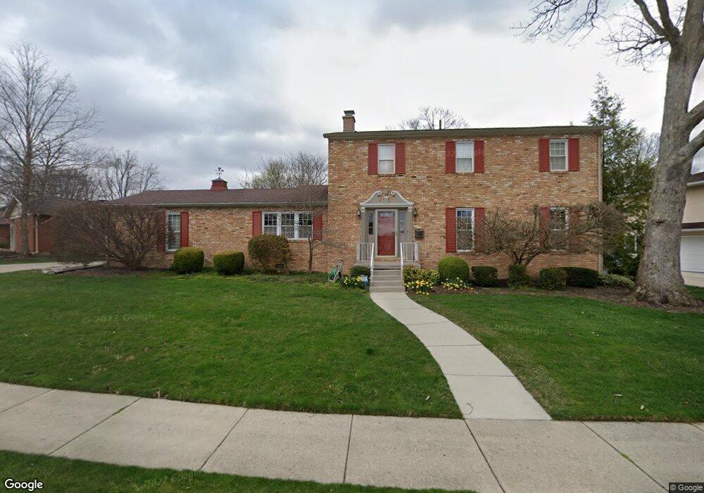
3000 Clarion Dr Springfield, OH 45503
Estimated Value: $313,213 - $356,000
4
Beds
3
Baths
2,538
Sq Ft
$130/Sq Ft
Est. Value
About This Home
This home is located at 3000 Clarion Dr, Springfield, OH 45503 and is currently estimated at $330,303, approximately $130 per square foot. 3000 Clarion Dr is a home located in Clark County with nearby schools including Kenton Elementary School, Roosevelt Middle School, and Springfield High School.
Ownership History
Date
Name
Owned For
Owner Type
Purchase Details
Closed on
May 18, 2004
Sold by
Broock Sharon A and Broock Leslie R
Bought by
Broock Sharon Ann and The Sharon Ann Broock Living Trust
Current Estimated Value
Purchase Details
Closed on
Jan 6, 2001
Sold by
Salerno Frank W and Salerno Holly S
Bought by
Broock Sharon A
Home Financials for this Owner
Home Financials are based on the most recent Mortgage that was taken out on this home.
Original Mortgage
$147,900
Interest Rate
7.13%
Mortgage Type
Purchase Money Mortgage
Create a Home Valuation Report for This Property
The Home Valuation Report is an in-depth analysis detailing your home's value as well as a comparison with similar homes in the area
Home Values in the Area
Average Home Value in this Area
Purchase History
| Date | Buyer | Sale Price | Title Company |
|---|---|---|---|
| Broock Sharon Ann | -- | -- | |
| Broock Sharon A | $184,900 | -- |
Source: Public Records
Mortgage History
| Date | Status | Borrower | Loan Amount |
|---|---|---|---|
| Previous Owner | Broock Sharon A | $147,900 |
Source: Public Records
Tax History
| Year | Tax Paid | Tax Assessment Tax Assessment Total Assessment is a certain percentage of the fair market value that is determined by local assessors to be the total taxable value of land and additions on the property. | Land | Improvement |
|---|---|---|---|---|
| 2025 | $2,973 | $95,820 | $16,760 | $79,060 |
| 2024 | $2,926 | $69,880 | $14,720 | $55,160 |
| 2023 | $2,926 | $69,880 | $14,720 | $55,160 |
| 2022 | $3,018 | $69,880 | $14,720 | $55,160 |
| 2021 | $2,922 | $63,340 | $11,970 | $51,370 |
| 2020 | $2,928 | $63,340 | $11,970 | $51,370 |
| 2019 | $2,936 | $63,340 | $11,970 | $51,370 |
| 2018 | $2,489 | $53,250 | $9,430 | $43,820 |
| 2017 | $2,487 | $58,629 | $9,426 | $49,203 |
| 2016 | $2,490 | $58,629 | $9,426 | $49,203 |
| 2015 | $1,062 | $52,924 | $8,978 | $43,946 |
| 2014 | $2,337 | $52,924 | $8,978 | $43,946 |
| 2013 | $2,312 | $52,924 | $8,978 | $43,946 |
Source: Public Records
Map
Nearby Homes
- 2824 Balsam Dr
- 3135 Imperial Blvd
- 3021 Argonne Ln N
- 3027 Argonne Ln N Unit 3027
- 516 Rensselaer St
- 3153 Argonne Ln N
- 3124 El Camino Dr
- 615 Villa Rd Unit K
- 3250 Argonne Ln N
- 3247 Argonne Ln N Unit 3247
- 2951 Archer Ln
- 2540 Rebecca Dr
- 2553 Derr Rd
- 366 Northfield Blvd Unit 1C
- 1046 Fruitland Rd
- 224 Roscommon Dr
- 1032 Armsgate Rd
- 2153 Olympic St Unit 2153
- 1040 Carson Ln
- 1139 Bradford Dr
- 715 Weybridge Dr
- 3008 Clarion Dr
- 3007 Linmuth Dr W
- 729 Linmuth Ct S
- 730 Weybridge Dr
- 3016 Clarion Dr
- 701 Weybridge Dr
- 3001 Clarion Dr
- 3005 Clarion Dr
- 3007 Clarion Dr
- 3015 Linmuth Dr W
- 711 Weybridge Dr
- 750 Weybridge Dr
- 745 Linmuth Ct S
- 745 S Linmuth Ct
- 3024 Clarion Dr
- 3015 Clarion Dr
- 731 Weybridge Dr
- 3023 Linmuth Dr W
- 800 Weybridge Dr
Your Personal Tour Guide
Ask me questions while you tour the home.