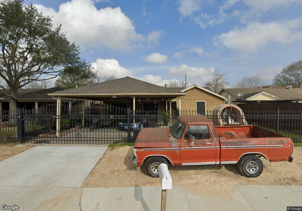
3001 Kowis St Houston, TX 77093
East Aldine NeighborhoodEstimated Value: $187,301 - $221,000
3
Beds
2
Baths
1,308
Sq Ft
$154/Sq Ft
Est. Value
About This Home
This home is located at 3001 Kowis St, Houston, TX 77093 and is currently estimated at $202,075, approximately $154 per square foot. 3001 Kowis St is a home located in Harris County with nearby schools including Scarborough Elementary School, Patrick Henry Middle School, and Sam Houston Math, Science & Technology Center.
Ownership History
Date
Name
Owned For
Owner Type
Purchase Details
Closed on
May 4, 2007
Sold by
Sosa Samuel
Bought by
Saldivar Frances A
Current Estimated Value
Purchase Details
Closed on
Nov 20, 1997
Sold by
Federal Deposit Insurance Corporation
Bought by
Saldivar Jose Noe and Saldivar Frances A
Purchase Details
Closed on
Jun 16, 1995
Sold by
First Nationwide Bank Fsb
Bought by
The Federal Deposit Insurance Corp and Fslic Resolution Fund
Create a Home Valuation Report for This Property
The Home Valuation Report is an in-depth analysis detailing your home's value as well as a comparison with similar homes in the area
Home Values in the Area
Average Home Value in this Area
Purchase History
| Date | Buyer | Sale Price | Title Company |
|---|---|---|---|
| Saldivar Frances A | -- | None Available | |
| Saldivar Jose Noe | -- | -- | |
| The Federal Deposit Insurance Corp | -- | -- |
Source: Public Records
Tax History Compared to Growth
Tax History
| Year | Tax Paid | Tax Assessment Tax Assessment Total Assessment is a certain percentage of the fair market value that is determined by local assessors to be the total taxable value of land and additions on the property. | Land | Improvement |
|---|---|---|---|---|
| 2025 | $222 | $227,613 | $40,308 | $187,305 |
| 2024 | $222 | $227,613 | $40,308 | $187,305 |
| 2023 | $200 | $253,475 | $40,308 | $213,167 |
| 2022 | $1,848 | $204,160 | $30,844 | $173,316 |
| 2021 | $1,784 | $162,349 | $30,844 | $131,505 |
| 2020 | $1,687 | $138,974 | $30,844 | $108,130 |
| 2019 | $1,600 | $138,974 | $30,844 | $108,130 |
| 2018 | $308 | $67,884 | $30,844 | $37,040 |
| 2017 | $1,421 | $67,884 | $30,844 | $37,040 |
| 2016 | $1,292 | $67,884 | $30,844 | $37,040 |
| 2015 | $276 | $54,833 | $19,278 | $35,555 |
| 2014 | $276 | $54,833 | $19,278 | $35,555 |
Source: Public Records
Map
Nearby Homes
- 2629 Kowis St
- 2817 Cromwell St
- 2636 Lone Oak Rd
- 1728 Little York Rd
- 1904 Little York Rd
- 3418 Hopper Rd
- 2915 Brea Crest St
- 3214 Brea Crest St
- 2311 Warwick Rd
- 2237 Cromwell St
- 3804 Cedar Hill Ln
- 11716 Innsbury Dr
- 2152 William Tell St
- 3111 Hartwick Rd
- 2326 Sunny Dr
- 2306 Wardmont St
- 2122 Kowis St
- 11746 Somerset Ln
- 2723 Castledale Dr
- 2315 Langley Rd
- 3005 Kowis St
- 2925 Kowis St
- 2921 Kowis St
- 3009 Kowis St
- 3002 Cedar Hill Ln
- 3006 Cedar Hill Ln
- 2926 Cedar Hill Ln
- 3013 Kowis St
- 2922 Cedar Hill Ln
- 3010 Cedar Hill Ln
- 2917 Kowis St
- 2918 Cedar Hill Ln
- 3014 Cedar Hill Ln
- 3017 Kowis St
- 3018 Cedar Hill Ln
- 2914 Cedar Hill Ln
- 3022 Cedar Hill Ln
- 2910 Cedar Hill Ln
- 10955 Royal Pine Dr
- 3001 Cedar Hill Ln