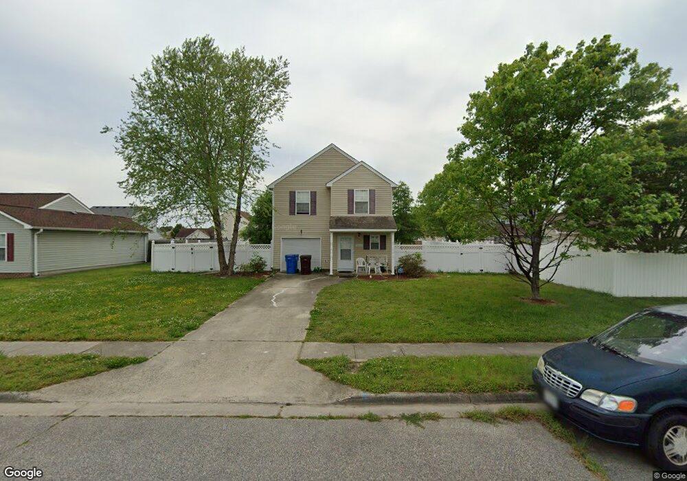
3005 Bill Reid Ct Chesapeake, VA 23324
Indian River NeighborhoodEstimated Value: $353,000 - $376,000
4
Beds
3
Baths
1,776
Sq Ft
$205/Sq Ft
Est. Value
About This Home
This home is located at 3005 Bill Reid Ct, Chesapeake, VA 23324 and is currently estimated at $363,784, approximately $204 per square foot. 3005 Bill Reid Ct is a home located in Chesapeake City with nearby schools including Thurgood Marshall Elementary School, Oscar Smith Middle School, and Oscar F Smith High.
Ownership History
Date
Name
Owned For
Owner Type
Purchase Details
Closed on
Mar 27, 2007
Sold by
South Hampton Rds Habitat
Bought by
Bryant Paulette
Current Estimated Value
Home Financials for this Owner
Home Financials are based on the most recent Mortgage that was taken out on this home.
Original Mortgage
$119,511
Outstanding Balance
$72,656
Interest Rate
6.25%
Mortgage Type
New Conventional
Estimated Equity
$291,128
Create a Home Valuation Report for This Property
The Home Valuation Report is an in-depth analysis detailing your home's value as well as a comparison with similar homes in the area
Home Values in the Area
Average Home Value in this Area
Purchase History
| Date | Buyer | Sale Price | Title Company |
|---|---|---|---|
| Bryant Paulette | $226,000 | -- |
Source: Public Records
Mortgage History
| Date | Status | Borrower | Loan Amount |
|---|---|---|---|
| Open | Bryant Paulette | $119,511 | |
| Closed | Bryant Paulette | $15,543 | |
| Closed | Bryant Paulette | $95,573 |
Source: Public Records
Tax History Compared to Growth
Tax History
| Year | Tax Paid | Tax Assessment Tax Assessment Total Assessment is a certain percentage of the fair market value that is determined by local assessors to be the total taxable value of land and additions on the property. | Land | Improvement |
|---|---|---|---|---|
| 2025 | $3,419 | $364,400 | $100,000 | $264,400 |
| 2024 | $3,419 | $338,500 | $90,000 | $248,500 |
| 2023 | $2,638 | $298,900 | $80,000 | $218,900 |
| 2022 | $2,628 | $260,200 | $65,000 | $195,200 |
| 2021 | $2,279 | $217,000 | $55,000 | $162,000 |
| 2020 | $2,138 | $203,600 | $55,000 | $148,600 |
| 2019 | $2,045 | $194,800 | $55,000 | $139,800 |
| 2018 | $1,932 | $177,800 | $55,000 | $122,800 |
| 2017 | $1,867 | $177,800 | $55,000 | $122,800 |
| 2016 | $1,867 | $177,800 | $55,000 | $122,800 |
| 2015 | $1,867 | $177,800 | $55,000 | $122,800 |
| 2014 | $1,867 | $177,800 | $55,000 | $122,800 |
Source: Public Records
Map
Nearby Homes
- 2836 Parkside Dr
- 708 Stalham Rd
- 2915 Berkley Ave
- 2904 Berkley Ave
- 305 Keith Ct
- 1317 Yeadon Rd
- 1309 Drayton Rd
- 2702 Cayce Dr
- 3005 Scotia Dr
- 2929 Hilton Ave
- 506 Stalham Rd
- 1201 Algona Rd
- 2603 Berkley Ave
- 2916 Doris Ave
- 2905 Doris Ave
- 502 Mooney Rd
- 2924 Candlewood Cir
- 2820 Garrett St
- 1330 Wingfield Ave
- 3303 Rokeby Ave
- 3009 Bill Reid Ct
- 2024 Windy Rd
- 2028 Windy Rd
- 3008 Armentrout Ct
- 3013 Bill Reid Ct
- 3004 Armentrout Ct
- 3012 Armentrout Ct
- 3004 Bill Reid Ct
- 2016 Windy Rd
- 3000 Armentrout Ct
- 3008 Bill Reid Ct
- 3017 Bill Reid Ct
- 2012 Windy Rd
- 3016 Armentrout Ct
- 3012 Bill Reid Ct
- 3020 Bill Reid Ct
- 3005 Armentrout Ct
- 2008 Windy Rd
- 3016 Bill Reid Ct
- 3001 Armentrout Ct