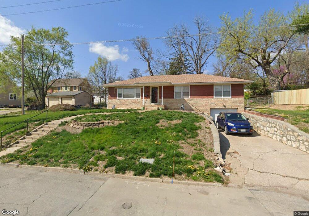
3007 Miller Ave Saint Joseph, MO 64506
Ashland NeighborhoodEstimated Value: $198,000 - $219,000
--
Bed
--
Bath
1,200
Sq Ft
$175/Sq Ft
Est. Value
About This Home
This home is located at 3007 Miller Ave, Saint Joseph, MO 64506 and is currently estimated at $209,573, approximately $174 per square foot. 3007 Miller Ave is a home located in Buchanan County with nearby schools including Field Elementary School, Bode Middle School, and Central High School.
Ownership History
Date
Name
Owned For
Owner Type
Purchase Details
Closed on
Apr 30, 2018
Sold by
Angold Thomas J and Angold Patsy A
Bought by
Corbly Michael and Corbly Connie
Current Estimated Value
Home Financials for this Owner
Home Financials are based on the most recent Mortgage that was taken out on this home.
Original Mortgage
$121,510
Outstanding Balance
$104,720
Interest Rate
4.44%
Mortgage Type
New Conventional
Estimated Equity
$104,853
Purchase Details
Closed on
Jun 29, 2007
Sold by
Galyean Damon J and Galyean Leslie A
Bought by
Angold Thomas J and Angold Patsy A
Home Financials for this Owner
Home Financials are based on the most recent Mortgage that was taken out on this home.
Original Mortgage
$108,500
Interest Rate
6.19%
Mortgage Type
New Conventional
Create a Home Valuation Report for This Property
The Home Valuation Report is an in-depth analysis detailing your home's value as well as a comparison with similar homes in the area
Home Values in the Area
Average Home Value in this Area
Purchase History
| Date | Buyer | Sale Price | Title Company |
|---|---|---|---|
| Corbly Michael | -- | None Available | |
| Angold Thomas J | -- | St Joseph Title & Abstract C |
Source: Public Records
Mortgage History
| Date | Status | Borrower | Loan Amount |
|---|---|---|---|
| Open | Corbly Michael | $121,510 | |
| Previous Owner | Angold Thomas J | $108,500 |
Source: Public Records
Tax History Compared to Growth
Tax History
| Year | Tax Paid | Tax Assessment Tax Assessment Total Assessment is a certain percentage of the fair market value that is determined by local assessors to be the total taxable value of land and additions on the property. | Land | Improvement |
|---|---|---|---|---|
| 2024 | $1,203 | $16,690 | $4,280 | $12,410 |
| 2023 | $1,203 | $16,690 | $4,280 | $12,410 |
| 2022 | $1,111 | $16,690 | $4,280 | $12,410 |
| 2021 | $1,116 | $16,690 | $4,280 | $12,410 |
| 2020 | $1,109 | $16,690 | $4,280 | $12,410 |
| 2019 | $1,071 | $16,690 | $4,280 | $12,410 |
| 2018 | $968 | $16,690 | $4,280 | $12,410 |
| 2017 | $959 | $16,690 | $0 | $0 |
| 2015 | $0 | $16,690 | $0 | $0 |
| 2014 | $1,051 | $16,690 | $0 | $0 |
Source: Public Records
Map
Nearby Homes
- 3028 Ashland Ave
- 2519 Forest Ave
- 3015 Miller Rd
- 3128 Floral Ave
- 00 Lot 2 Highway 169
- 00 Lot 1 Highway 169
- 3815 Miller Rd
- 2110 Ashland Ave
- 3004 C Garden Gate N A N
- 3315 Chatham Ave
- 3326 Chatham Ave
- 3111 N 35th St
- 2102 N 34th Terrace
- 3412 N 35th Place
- 2211 Lovers Ln
- 3101 Douglas St
- 4411 Rochester Rd
- 4301 N 169 Hwy
- 3309 Westwood Dr
- 2906 Cook Rd
- 3015 Miller Ave
- 2805 Ashland Ave
- 2807 Ashland Ave
- 3010 Miller Ave
- 3008 Miller Ave
- 2821 Ashland Ave
- 3000 Miller Ave
- 3012 Miller Ave
- 3017 Miller Ave
- 3018 Miller Ave
- 3020 Dale Ave
- 3033 Miller Ave
- 2827 Ashland Ave
- 3024 Dale Ave
- 3022 Miller Ave
- 3026 Dale Ave
- 3035 Miller Ave
- 3026 Miller Ave
- 2804 N 31st St
- 3019 Gene Field Rd