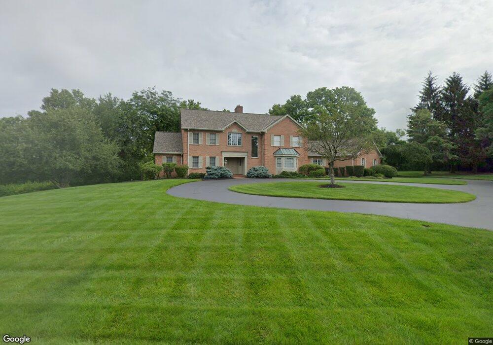
3008 Burning Tree Ln Cincinnati, OH 45237
Estimated Value: $892,183 - $1,140,000
4
Beds
5
Baths
3,852
Sq Ft
$270/Sq Ft
Est. Value
About This Home
This home is located at 3008 Burning Tree Ln, Cincinnati, OH 45237 and is currently estimated at $1,041,796, approximately $270 per square foot. 3008 Burning Tree Ln is a home located in Hamilton County with nearby schools including Pleasant Ridge Montessori School, Shroder High School, and Clark Montessori High School.
Ownership History
Date
Name
Owned For
Owner Type
Purchase Details
Closed on
Jun 15, 2010
Sold by
Loveberg Walter M and Lovenberg Marjorie Y
Bought by
Walter M Lovenberg Trust
Current Estimated Value
Create a Home Valuation Report for This Property
The Home Valuation Report is an in-depth analysis detailing your home's value as well as a comparison with similar homes in the area
Home Values in the Area
Average Home Value in this Area
Purchase History
| Date | Buyer | Sale Price | Title Company |
|---|---|---|---|
| Walter M Lovenberg Trust | -- | None Available |
Source: Public Records
Tax History Compared to Growth
Tax History
| Year | Tax Paid | Tax Assessment Tax Assessment Total Assessment is a certain percentage of the fair market value that is determined by local assessors to be the total taxable value of land and additions on the property. | Land | Improvement |
|---|---|---|---|---|
| 2024 | $12,315 | $220,661 | $40,271 | $180,390 |
| 2023 | $12,642 | $220,661 | $40,271 | $180,390 |
| 2022 | $12,169 | $185,171 | $39,571 | $145,600 |
| 2021 | $11,839 | $185,171 | $39,571 | $145,600 |
| 2020 | $12,042 | $185,171 | $39,571 | $145,600 |
| 2019 | $11,672 | $163,867 | $35,018 | $128,849 |
| 2018 | $11,693 | $163,867 | $35,018 | $128,849 |
| 2017 | $11,157 | $163,867 | $35,018 | $128,849 |
| 2016 | $12,021 | $168,918 | $36,768 | $132,150 |
| 2015 | $10,911 | $168,918 | $36,768 | $132,150 |
| 2014 | $10,987 | $168,918 | $36,768 | $132,150 |
| 2013 | $11,155 | $168,918 | $36,768 | $132,150 |
Source: Public Records
Map
Nearby Homes
- 7716 Creekwood Ln
- 2920 E Galbraith Rd
- 3275 Legacy Trace
- 3360 Legacy Trace
- L Apple Ridge Ln
- 2071 Longmeadow Ln
- 2127 Longmeadow Ln
- 2558 Apple Ridge Ln
- 2281 E Galbraith Rd
- 636 Maple Dr
- 796 Kenray Ct
- 7675 Sagamore Dr
- 7651 Sagamore Dr
- 0 Hill St Unit 1616370
- 6458 Crestview Ave
- 6462 Crestview Ave
- 6466 Crestview Ave
- 6470 Crestview Ave
- 2758 Losantiridge Ave
- 6542 Cliff Ridge Ave
- 3004 Burning Tree Ln
- 3012 Burning Tree Ln
- 3005 Burning Tree Ln
- 3002 Burning Tree Ln
- 3001 Burning Tree Ln
- 7717 Creekwood Ln
- 7720 Creekwood Ln
- 3016 Burning Tree Ln
- 3021 Burning Tree Ln
- 3075 Legacy Trace
- 3020 Burning Tree Ln
- 3055 Legacy Trace
- 3080 Legacy Trace
- 7585 Ridge Rd
- 7585 Ridge Rd
- 3024 Burning Tree Ln
- 7712 Creekwood Ln
- 3025 Burning Tree Ln
- 7550 French Park Place
- 3095 Legacy Trace