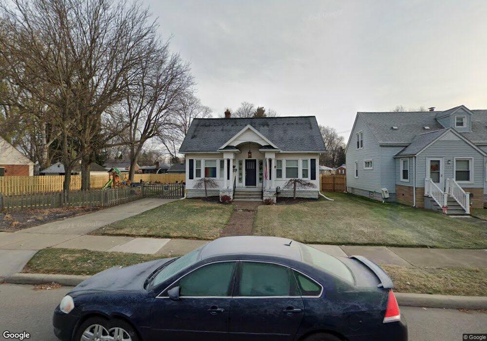
301 Crocker Blvd Mount Clemens, MI 48043
Estimated Value: $185,000 - $236,000
3
Beds
2
Baths
1,350
Sq Ft
$159/Sq Ft
Est. Value
About This Home
This home is located at 301 Crocker Blvd, Mount Clemens, MI 48043 and is currently estimated at $214,663, approximately $159 per square foot. 301 Crocker Blvd is a home located in Macomb County with nearby schools including Mount Clemens High School, Montessori Stepping Stones School, and St Mary Catholic School.
Ownership History
Date
Name
Owned For
Owner Type
Purchase Details
Closed on
Jan 4, 2011
Sold by
King Marsha
Bought by
Roupe Sarah
Current Estimated Value
Purchase Details
Closed on
Dec 28, 2007
Sold by
Carney Earl J and Carney Rebecca
Bought by
Hsbc Bank Usa Na and Ace Securities Corp Home Equity Loan Tr
Purchase Details
Closed on
Apr 27, 2006
Sold by
Madigan Patrice A
Bought by
Carney Earl and Carney Rebecca
Purchase Details
Closed on
Sep 25, 1995
Sold by
Nellis R and Nellis S
Bought by
Madigan P
Create a Home Valuation Report for This Property
The Home Valuation Report is an in-depth analysis detailing your home's value as well as a comparison with similar homes in the area
Home Values in the Area
Average Home Value in this Area
Purchase History
| Date | Buyer | Sale Price | Title Company |
|---|---|---|---|
| Roupe Sarah | $54,900 | Greco | |
| King Marsha | -- | Greco | |
| Hsbc Bank Usa Na | $112,404 | None Available | |
| Carney Earl | $135,000 | Metropolitan Title Company | |
| Madigan P | $83,000 | -- |
Source: Public Records
Tax History Compared to Growth
Tax History
| Year | Tax Paid | Tax Assessment Tax Assessment Total Assessment is a certain percentage of the fair market value that is determined by local assessors to be the total taxable value of land and additions on the property. | Land | Improvement |
|---|---|---|---|---|
| 2025 | $2,784 | $93,000 | $0 | $0 |
| 2024 | $2,712 | $84,700 | $0 | $0 |
| 2023 | $2,598 | $81,300 | $0 | $0 |
| 2022 | $2,512 | $72,900 | $0 | $0 |
| 2021 | $2,455 | $62,500 | $0 | $0 |
| 2020 | $2,331 | $57,000 | $0 | $0 |
| 2019 | $2,294 | $50,400 | $0 | $0 |
| 2018 | $2,250 | $45,900 | $0 | $0 |
| 2017 | $2,206 | $41,266 | $11,411 | $29,855 |
| 2016 | $2,198 | $41,266 | $0 | $0 |
| 2015 | $1,920 | $38,594 | $0 | $0 |
| 2013 | -- | $36,741 | $11,411 | $25,330 |
Source: Public Records
Map
Nearby Homes
- 167 Avery St
- 260 Riverside Dr
- 190 Riverside Dr
- 39058 Charbeneau St
- 184 Dickinson St
- 38747 Harper Ave
- 104 Riverside Dr
- 30 Mulligan Dr
- 44 Fessenden St
- 38580 Asbury Park St
- 88 Crocker Blvd
- 38481 Riverside Dr
- 55 Meadle St
- 41 Gibbs St
- 102 Michigan St
- 50 Michigan St
- 147 Barbara St
- 24591 N River Rd
- 162 Barbara St
- 38990 Lanse Creuse St
- 303 Crocker Blvd
- 285 Crocker Blvd
- 267 Crocker Blvd Unit 269
- 194 Eastman St
- 190 Eastman St
- 176 Eastman St
- 265 Crocker Blvd
- 170 Eastman St
- 317 Crocker Blvd
- 322 Crocker Blvd
- 263 Crocker Blvd Unit 12
- 258 Crocker Blvd
- 256 Crocker Blvd
- 164 Eastman St
- 261 Crocker Blvd
- 252 Crocker Blvd
- 162 Eastman St
- 171 Avery St
- 169 Avery St
- 179 Eastman St