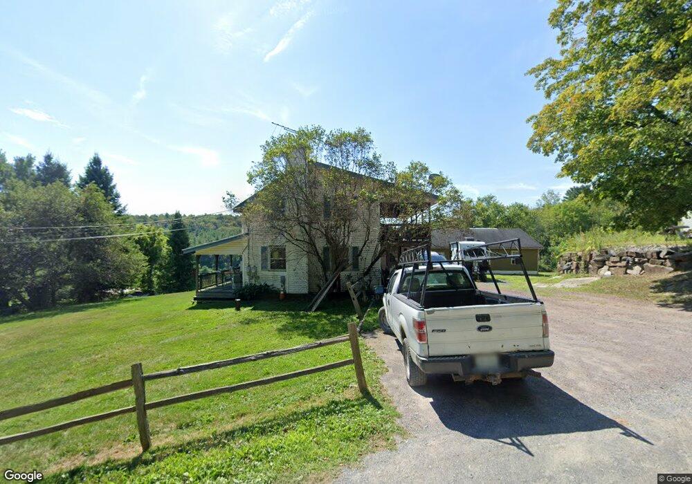
301 Hawk Rd Comstock, NY 12821
Estimated Value: $255,000 - $326,135
4
Beds
2
Baths
1,320
Sq Ft
$220/Sq Ft
Est. Value
About This Home
This home is located at 301 Hawk Rd, Comstock, NY 12821 and is currently estimated at $290,568, approximately $220 per square foot. 301 Hawk Rd is a home with nearby schools including Fort Ann Elementary School and Fort Ann Middle/High School.
Ownership History
Date
Name
Owned For
Owner Type
Purchase Details
Closed on
Nov 7, 2016
Sold by
Orr Kevin T
Bought by
Fort Ann Holdings Llc
Current Estimated Value
Purchase Details
Closed on
Feb 25, 2005
Sold by
Bigelow Ruth
Bought by
Orr Kevin
Home Financials for this Owner
Home Financials are based on the most recent Mortgage that was taken out on this home.
Original Mortgage
$103,490
Interest Rate
5.66%
Mortgage Type
Unknown
Purchase Details
Closed on
Dec 2, 2004
Sold by
Monahan Rusty
Bought by
Bigelow Ruth
Purchase Details
Closed on
Feb 7, 1996
Sold by
Morse Wayne
Bought by
Monahan Rusty and Shevy Sherri
Create a Home Valuation Report for This Property
The Home Valuation Report is an in-depth analysis detailing your home's value as well as a comparison with similar homes in the area
Home Values in the Area
Average Home Value in this Area
Purchase History
| Date | Buyer | Sale Price | Title Company |
|---|---|---|---|
| Fort Ann Holdings Llc | -- | Robert H. Hafner | |
| Orr Kevin | $129,320 | Mark Delsignore | |
| Bigelow Ruth | -- | -- | |
| Monahan Rusty | $59,100 | -- |
Source: Public Records
Mortgage History
| Date | Status | Borrower | Loan Amount |
|---|---|---|---|
| Previous Owner | Orr Kevin | $103,490 |
Source: Public Records
Tax History
| Year | Tax Paid | Tax Assessment Tax Assessment Total Assessment is a certain percentage of the fair market value that is determined by local assessors to be the total taxable value of land and additions on the property. | Land | Improvement |
|---|---|---|---|---|
| 2024 | $6,297 | $381,900 | $38,200 | $343,700 |
| 2023 | $4,958 | $198,000 | $21,500 | $176,500 |
| 2022 | $4,537 | $198,000 | $21,500 | $176,500 |
| 2021 | $4,455 | $180,000 | $21,500 | $158,500 |
| 2020 | $7,032 | $180,000 | $21,500 | $158,500 |
| 2019 | $6,885 | $180,000 | $21,500 | $158,500 |
| 2018 | $6,885 | $180,000 | $21,500 | $158,500 |
| 2017 | $3,477 | $148,700 | $21,500 | $127,200 |
| 2016 | $3,453 | $148,700 | $21,500 | $127,200 |
| 2015 | -- | $148,700 | $21,500 | $127,200 |
| 2014 | -- | $148,700 | $21,500 | $127,200 |
Source: Public Records
Map
Nearby Homes
- 501 N North Old Route 4 Rd
- 106 Kelsey Pond Ln
- 471 Clay Hill Rd
- 367 Clay Hill Rd
- L12 Artillery Patent
- L1 Rathbunville Ln
- 11019 State Route 22
- 10329 State Route 40
- 81 Rathbunville Ln
- 10406 New York 40
- 14 Upper Turnpike
- 25 Sunset Ave
- 18 Lower Turnpike Rd
- 92 Morse Ln
- 103 Hatch Hill Rd
- 79 Keller Ln
- L64 L24 Honeysuckle Dr
- 8186 State Route 40
- 88 Aiken Rd
- 2 Scenic Hill Way
- 295 Hawk Rd
- 336 Hawk Rd
- 247 Hawk Rd
- 301 Hawk
- 187 N Quarry Rd
- 213 Hawk Rd
- 199 Hawk Rd
- 190 Hawk Rd
- 0 Hawk Rd Unit 74629
- 0 Hawk Rd Unit 113673
- 0 Hawk Rd Unit 89321
- 0 Hawk Rd
- 000 Hawk Rd
- 0 Hawk Rd Unit 93430
- 0 Hawk Rd Unit 77775
- 12752 Hawk Rd
- 0 Hawk Rd Unit 202216222
- 0 Hawk Rd Unit 202211742
- 0 Hawk Rd Unit 202111605
- 0 Hawk Rd Unit 183030
Your Personal Tour Guide
Ask me questions while you tour the home.