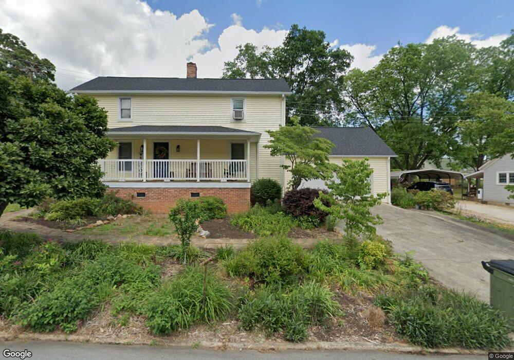
301 Jaynes St Walhalla, SC 29691
Estimated Value: $218,000 - $229,000
3
Beds
1
Bath
1,743
Sq Ft
$127/Sq Ft
Est. Value
About This Home
This home is located at 301 Jaynes St, Walhalla, SC 29691 and is currently estimated at $221,900, approximately $127 per square foot. 301 Jaynes St is a home located in Oconee County with nearby schools including James M. Brown Elementary School, Walhalla Middle School, and Walhalla High School.
Ownership History
Date
Name
Owned For
Owner Type
Purchase Details
Closed on
Feb 24, 2022
Sold by
Lou Cushman Mary
Bought by
Fullam Eric Michael and Fullam Brady Lynn
Current Estimated Value
Home Financials for this Owner
Home Financials are based on the most recent Mortgage that was taken out on this home.
Original Mortgage
$154,850
Outstanding Balance
$143,516
Interest Rate
3.55%
Mortgage Type
New Conventional
Estimated Equity
$78,384
Purchase Details
Closed on
Dec 12, 2014
Sold by
Cushman Mary Lou and Land Mary Lou
Bought by
Smith Rachel Land
Create a Home Valuation Report for This Property
The Home Valuation Report is an in-depth analysis detailing your home's value as well as a comparison with similar homes in the area
Home Values in the Area
Average Home Value in this Area
Purchase History
| Date | Buyer | Sale Price | Title Company |
|---|---|---|---|
| Fullam Eric Michael | $163,000 | Bradley K Richardson Pc | |
| Smith Rachel Land | -- | -- |
Source: Public Records
Mortgage History
| Date | Status | Borrower | Loan Amount |
|---|---|---|---|
| Open | Fullam Eric Michael | $154,850 |
Source: Public Records
Tax History
| Year | Tax Paid | Tax Assessment Tax Assessment Total Assessment is a certain percentage of the fair market value that is determined by local assessors to be the total taxable value of land and additions on the property. | Land | Improvement |
|---|---|---|---|---|
| 2025 | $2,769 | $6,092 | $632 | $5,460 |
| 2024 | $2,751 | $6,092 | $632 | $5,460 |
| 2023 | $2,705 | $6,092 | $632 | $5,460 |
| 2022 | $1,468 | $3,280 | $853 | $2,427 |
| 2021 | $96 | $3,148 | $853 | $2,295 |
| 2020 | $96 | $2,890 | $782 | $2,108 |
| 2019 | $96 | $0 | $0 | $0 |
| 2018 | $633 | $0 | $0 | $0 |
| 2017 | $95 | $0 | $0 | $0 |
| 2016 | $95 | $0 | $0 | $0 |
| 2015 | -- | $0 | $0 | $0 |
| 2014 | -- | $2,513 | $773 | $1,740 |
| 2013 | -- | $0 | $0 | $0 |
Source: Public Records
Map
Nearby Homes
- 320 Jaynes St
- 00 Keowee St
- 326 Kenneth St
- 2423 Westminster Hwy
- 807 W Main St
- 318 S Pine St
- 606 W South Broad St
- 209 Moore Ave
- 00 N Church St
- 109 S Laurel St
- 107 S Laurel St
- 804 W North Broad St
- 00 Abbott Ln
- 384 E Woodland Dr
- 147 White Oak St
- 223 N Dogwood Dr
- 00 Fox Run Rd
- 323 Fox Run Rd
- Lot 57 Fox Run Rd
- 606 N Poplar St
Your Personal Tour Guide
Ask me questions while you tour the home.