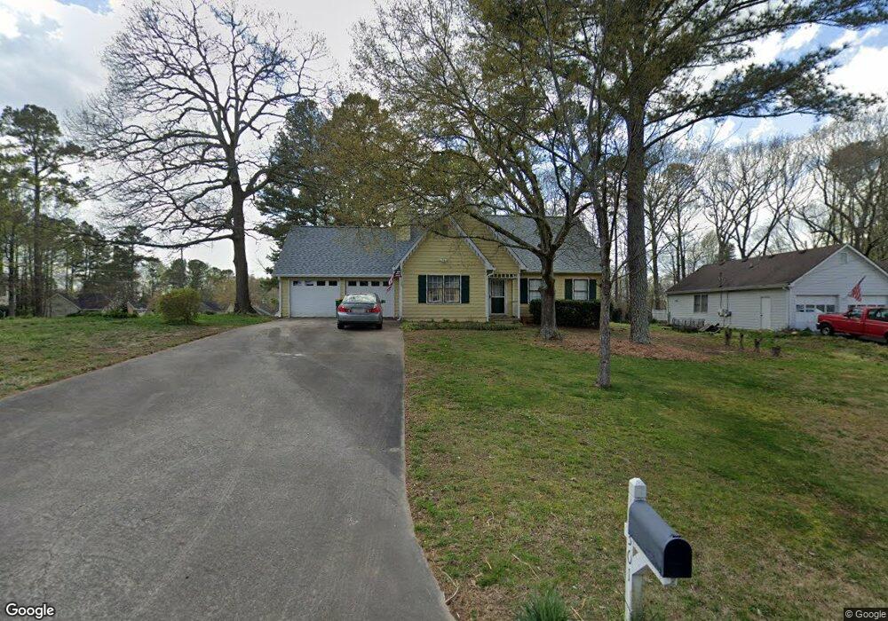
301 N Briar Ridge Woodstock, GA 30189
Sutallee NeighborhoodEstimated Value: $366,000 - $369,643
4
Beds
3
Baths
1,664
Sq Ft
$221/Sq Ft
Est. Value
About This Home
This home is located at 301 N Briar Ridge, Woodstock, GA 30189 and is currently estimated at $367,822, approximately $221 per square foot. 301 N Briar Ridge is a home located in Cherokee County with nearby schools including Boston Elementary School, E. T. Booth Middle School, and Etowah High School.
Ownership History
Date
Name
Owned For
Owner Type
Purchase Details
Closed on
Oct 24, 2008
Sold by
Pledged Property Ii Llc
Bought by
Mctigue Cameron L
Current Estimated Value
Home Financials for this Owner
Home Financials are based on the most recent Mortgage that was taken out on this home.
Original Mortgage
$113,526
Outstanding Balance
$73,508
Interest Rate
5.89%
Mortgage Type
VA
Estimated Equity
$294,314
Purchase Details
Closed on
May 6, 2008
Sold by
Crutchfield Tamara L
Bought by
Pledged Property Ii Llc
Create a Home Valuation Report for This Property
The Home Valuation Report is an in-depth analysis detailing your home's value as well as a comparison with similar homes in the area
Home Values in the Area
Average Home Value in this Area
Purchase History
| Date | Buyer | Sale Price | Title Company |
|---|---|---|---|
| Mctigue Cameron L | $109,900 | -- | |
| Pledged Property Ii Llc | $103,500 | -- |
Source: Public Records
Mortgage History
| Date | Status | Borrower | Loan Amount |
|---|---|---|---|
| Open | Mctigue Cameron L | $113,526 |
Source: Public Records
Tax History Compared to Growth
Tax History
| Year | Tax Paid | Tax Assessment Tax Assessment Total Assessment is a certain percentage of the fair market value that is determined by local assessors to be the total taxable value of land and additions on the property. | Land | Improvement |
|---|---|---|---|---|
| 2024 | $651 | $126,292 | $28,000 | $98,292 |
| 2023 | $495 | $120,812 | $27,200 | $93,612 |
| 2022 | $610 | $103,732 | $23,200 | $80,532 |
| 2021 | $583 | $82,732 | $19,440 | $63,292 |
| 2020 | $553 | $74,012 | $17,200 | $56,812 |
| 2019 | $522 | $65,880 | $15,400 | $50,480 |
| 2018 | $521 | $62,880 | $14,000 | $48,880 |
| 2017 | $501 | $146,000 | $13,200 | $45,200 |
| 2016 | $501 | $136,900 | $13,200 | $41,560 |
| 2015 | $484 | $128,700 | $13,200 | $38,280 |
| 2014 | $438 | $116,500 | $13,280 | $33,320 |
Source: Public Records
Map
Nearby Homes
- 0 Black Oak Trail Unit 10267626
- 0 Black Oak Trail Unit 7303191
- 306 N Briar Ridge
- 104 Rose Cottage Ln Unit 65
- 7307 Carriage Creek Rd
- 1001 Deer Hollow Dr
- 124 Dockside Downs Dr
- 204 Captains Quarters
- 308 Mainsail Ln
- 507 Huntgate Rd
- 7119 Big Woods Dr
- 146 Sunset Ln
- 112 Countryside Ct
- 2006 Hawthorne Way
- 313 Maltibe Dr
- 1028 Deer Hollow Dr
- 616 Victoria Ln
- 107 Cottage Oaks Ln Unit F5
- 0 Black Oak Trail Unit 10251256
- 0 Black Oak Trail Unit 7371600
- 0 Black Oak Trail Unit 3280496
- 0 Black Oak Trail Unit 3187924
- 0 Black Oak Trail Unit 3128192
- 0 Black Oak Trail Unit 8844460
- 0 Black Oak Trail Unit 8627439
- 0 Black Oak Trail Unit 8430956
- 0 Black Oak Trail Unit 3102126
- 0 Black Oak Trail Unit 3072243
- 0 Black Oak Trail
- 305 N Briar Ridge
- 402 Walnut Dr Unit II
- 113 Black Oak Trail
- 115 Black Oak Trail
- 404 Walnut Dr
- 302 N Briar Ridge
- 117 Black Oak Trail
- 406 Walnut Dr
- 111 Black Oak Trail