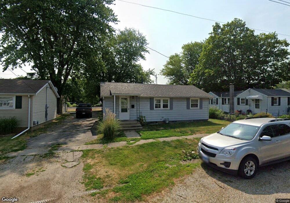
301 N Elm St Lewistown, IL 61542
Estimated Value: $56,587 - $88,000
--
Bed
--
Bath
--
Sq Ft
5,358
Sq Ft Lot
About This Home
This home is located at 301 N Elm St, Lewistown, IL 61542 and is currently estimated at $66,647. 301 N Elm St is a home located in Fulton County with nearby schools including Central Elementary School, Lewistown Elementary School, and Lewistown Junior/Senior High School.
Ownership History
Date
Name
Owned For
Owner Type
Purchase Details
Closed on
Nov 14, 2018
Sold by
Bainter Marvin R
Bought by
Havens John L and Havens Cindy K
Current Estimated Value
Home Financials for this Owner
Home Financials are based on the most recent Mortgage that was taken out on this home.
Original Mortgage
$33,300
Outstanding Balance
$25,209
Interest Rate
4.7%
Mortgage Type
Construction
Estimated Equity
$41,438
Purchase Details
Closed on
Jul 13, 2011
Sold by
Combswilliam S
Bought by
Baintermarvin
Create a Home Valuation Report for This Property
The Home Valuation Report is an in-depth analysis detailing your home's value as well as a comparison with similar homes in the area
Home Values in the Area
Average Home Value in this Area
Purchase History
| Date | Buyer | Sale Price | Title Company |
|---|---|---|---|
| Havens John L | $37,000 | Attorney Only | |
| Baintermarvin | $23,800 | -- |
Source: Public Records
Mortgage History
| Date | Status | Borrower | Loan Amount |
|---|---|---|---|
| Open | Havens John L | $33,300 |
Source: Public Records
Tax History Compared to Growth
Tax History
| Year | Tax Paid | Tax Assessment Tax Assessment Total Assessment is a certain percentage of the fair market value that is determined by local assessors to be the total taxable value of land and additions on the property. | Land | Improvement |
|---|---|---|---|---|
| 2024 | $758 | $15,240 | $1,050 | $14,190 |
| 2023 | $758 | $14,580 | $1,000 | $13,580 |
| 2022 | $755 | $14,580 | $1,000 | $13,580 |
| 2021 | $755 | $12,910 | $1,000 | $11,910 |
| 2020 | $642 | $12,480 | $970 | $11,510 |
| 2019 | $666 | $12,680 | $990 | $11,690 |
| 2018 | $1,255 | $12,440 | $970 | $11,470 |
| 2017 | $1,213 | $12,440 | $970 | $11,470 |
| 2016 | $1,202 | $12,020 | $940 | $11,080 |
| 2015 | $600 | $12,020 | $940 | $11,080 |
| 2013 | -- | $11,720 | $920 | $10,800 |
| 2012 | -- | $11,440 | $900 | $10,540 |
Source: Public Records
Map
Nearby Homes
- 111 N Broadway St
- 428 N Main St
- 101 W Macarthur Ave
- 602 E Nimintz Ave
- 200 W Avenue B
- 376 W Euclid Ave
- 704 S Main St
- 1026 N Main St
- 15937 U S 24
- 330 W Avenue G
- 13 Melrose Ln
- 0 N Highway 9 County Rd Unit RMAPA1260470
- 1124 S Illinois St
- 1428 N Main St
- 000 Highway 24
- 16853 N Wright Rd
- 12676 E County 14 Hwy
- County 14 Lot Unit WP001
- 14953 E Grain Bin Rd
- 10206 E County 14 Hwy
- 508 E Milton Ave
- 510 E Milton Ave
- 303 N Elm St
- 424 E Milton Ave
- 505 E Milton Ave
- 509 E Milton Ave
- 501 E Milton Ave
- 305 N Elm St
- 425 E Milton Ave
- 422 E Milton Ave
- 435 E Macarthur Ave
- 506 E Macarthur Ave
- 204 N Elm St
- 421 E Macarthur Ave
- 311 N Cedar St
- 402 N Elm St
- 305 N Broadway St
- 422 E Macarthur Ave
- 321 N Broadway St
- 417 N Cedar St