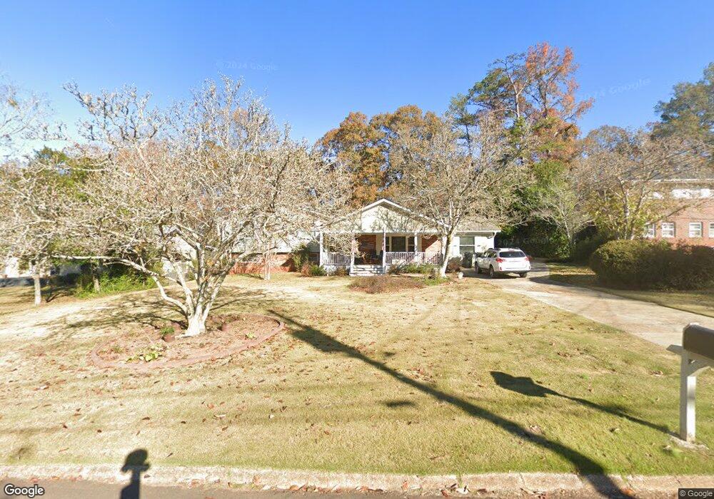
301 Neal St West Point, GA 31833
Estimated Value: $204,000 - $264,000
4
Beds
4
Baths
1,890
Sq Ft
$123/Sq Ft
Est. Value
About This Home
This home is located at 301 Neal St, West Point, GA 31833 and is currently estimated at $232,677, approximately $123 per square foot. 301 Neal St is a home located in Troup County with nearby schools including West Point Elementary School, Long Cane Elementary School, and Berta Weathersbee Elementary School.
Ownership History
Date
Name
Owned For
Owner Type
Purchase Details
Closed on
May 22, 2024
Sold by
Timmons Ann L
Bought by
Timmons Stephen B
Current Estimated Value
Purchase Details
Closed on
Apr 7, 2023
Sold by
Timmons Stephen B
Bought by
Timmons Stephen B and Timmons Ann L
Purchase Details
Closed on
Oct 4, 2012
Sold by
Timmons Helen H
Bought by
Timmons Stephen B and Timmons Vickie R
Purchase Details
Closed on
Jun 10, 1985
Sold by
Robert Timmons
Bought by
Timmons Helen H
Purchase Details
Closed on
Jan 1, 1961
Bought by
Robert Timmons
Create a Home Valuation Report for This Property
The Home Valuation Report is an in-depth analysis detailing your home's value as well as a comparison with similar homes in the area
Home Values in the Area
Average Home Value in this Area
Purchase History
| Date | Buyer | Sale Price | Title Company |
|---|---|---|---|
| Timmons Stephen B | -- | -- | |
| Timmons Stephen B | -- | -- | |
| Timmons Stephen B | -- | -- | |
| Timmons Helen H | -- | -- | |
| Robert Timmons | -- | -- |
Source: Public Records
Tax History Compared to Growth
Tax History
| Year | Tax Paid | Tax Assessment Tax Assessment Total Assessment is a certain percentage of the fair market value that is determined by local assessors to be the total taxable value of land and additions on the property. | Land | Improvement |
|---|---|---|---|---|
| 2024 | $2,593 | $79,320 | $8,000 | $71,320 |
| 2023 | $2,604 | $79,120 | $8,000 | $71,120 |
| 2022 | $1,857 | $74,280 | $8,000 | $66,280 |
| 2021 | $1,582 | $60,200 | $8,000 | $52,200 |
| 2020 | $1,272 | $58,720 | $8,000 | $50,720 |
| 2019 | $870 | $36,600 | $3,560 | $33,040 |
| 2018 | $1,045 | $34,640 | $3,200 | $31,440 |
| 2017 | $1,045 | $34,640 | $3,200 | $31,440 |
| 2016 | $1,013 | $33,591 | $3,200 | $30,391 |
| 2015 | $908 | $30,040 | $3,552 | $26,488 |
| 2014 | $867 | $28,646 | $3,552 | $25,094 |
| 2013 | -- | $30,197 | $3,552 | $26,645 |
Source: Public Records
Map
Nearby Homes
- 0 Ga Highway 0116 Unit 10619139
- 1903 Ridgewood Dr
- 1599 Highway 29
- 508 Pine St
- 1505 Wisteria Dr
- 1410 Roper Ave
- 1314 4th Ave
- 1008 E 12th St
- 0 Sunset Dr Unit 10451831
- 1007 4th Ave
- 713 Avenue H
- 0 Arrowhead Dr Unit 10451860
- 1508 N 4th Ave
- 712 4th Ave
- 804 E 6th St
- 509 Cleveland St
- 1095 County Road 212
- 4517 Georgia 18
- 4509 Georgia 18
- 4523 Georgia 18