Estimated Value: $304,565 - $336,000
4
Beds
2
Baths
2,654
Sq Ft
$120/Sq Ft
Est. Value
About This Home
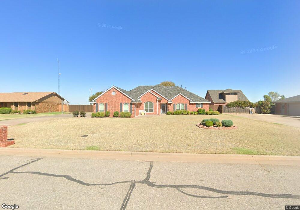
This home is located at 301 Pheasant Cir, Altus, OK 73521 and is currently estimated at $318,141, approximately $119 per square foot. 301 Pheasant Cir is a home located in Jackson County with nearby schools including Altus High School and Altus Christian Academy.
Ownership History
Date
Name
Owned For
Owner Type
Purchase Details
Closed on
Sep 2, 2005
Sold by
Arnold Richard W and Arnold Elaine J
Bought by
Arnold Richard W and Arnold Elanie J
Current Estimated Value
Home Financials for this Owner
Home Financials are based on the most recent Mortgage that was taken out on this home.
Original Mortgage
$131,000
Interest Rate
5.8%
Mortgage Type
New Conventional
Purchase Details
Closed on
Oct 31, 1994
Sold by
Vinyard Daniel and Vinyard Cynthia
Bought by
Arnold Richard and Arnold Elaine
Create a Home Valuation Report for This Property
The Home Valuation Report is an in-depth analysis detailing your home's value as well as a comparison with similar homes in the area
Purchase History
| Date | Buyer | Sale Price | Title Company |
|---|---|---|---|
| Arnold Richard W | -- | None Available | |
| Arnold Richard | $28,000 | -- |
Source: Public Records
Mortgage History
| Date | Status | Borrower | Loan Amount |
|---|---|---|---|
| Closed | Arnold Richard W | $131,000 |
Source: Public Records
Tax History
| Year | Tax Paid | Tax Assessment Tax Assessment Total Assessment is a certain percentage of the fair market value that is determined by local assessors to be the total taxable value of land and additions on the property. | Land | Improvement |
|---|---|---|---|---|
| 2025 | $2,423 | $29,049 | $4,624 | $24,425 |
| 2024 | $2,359 | $29,049 | $4,624 | $24,425 |
| 2023 | $2,359 | $27,382 | $4,624 | $22,758 |
| 2022 | $2,168 | $26,584 | $4,624 | $21,960 |
| 2021 | $2,239 | $27,207 | $4,234 | $22,973 |
| 2020 | $2,199 | $26,415 | $4,014 | $22,401 |
| 2019 | $2,151 | $25,646 | $3,800 | $21,846 |
| 2018 | $1,784 | $24,899 | $3,566 | $21,333 |
| 2017 | $1,730 | $24,173 | $3,339 | $20,834 |
| 2016 | $1,677 | $23,470 | $3,119 | $20,351 |
| 2015 | $1,626 | $22,786 | $2,973 | $19,813 |
| 2014 | $1,593 | $22,342 | $2,973 | $19,369 |
Source: Public Records
Map
Nearby Homes
- 3324 Continental Ct
- 300 Pintail Cir
- 3204 Partridge Place
- 3306 N Main St
- 3112 Partridge Place
- 3008 Mallard Ct
- 516 Quail Run S
- 3208 Peacock Ln
- 3609 Regal Dr
- 809 Candace Ln
- 3713 Regal Dr
- 3512 Kings Way
- 408 Mesa Verde Cir
- 909 Isabella Ln
- 2524 N Robin St
- 3616 Kings Way
- 912 Stephanie Ln
- 1001 Stephanie Ln
- 2404 N Robin St
- 1016 Northridge Blvd
- 305 Pheasant Cir
- 221 Pheasant Cir
- 309 Pheasant Cir
- 304 Pheasant Cir
- 300 Pheasant Cir
- 224 Pheasant Cir
- 217 Pheasant Cir
- 401 Pheasant Cir
- 308 Pheasant Cir
- 400 Pheasant Cir
- 3316 Continental Ct
- 305 Quail Run N
- 301 Quail Run N
- 405 Pheasant Cir
- 309 Quail Run N
- 225 Quail Run N
- 313 Quail Run N
- 217 Quail Run N
- 221 Quail Run N
- 317 Quail Run N
Your Personal Tour Guide
Ask me questions while you tour the home.