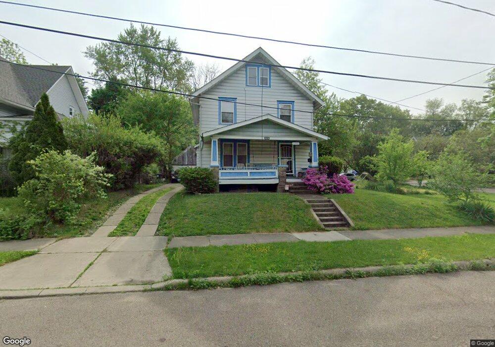
301 Shawnee Path Akron, OH 44305
Goodyear Heights NeighborhoodEstimated Value: $107,424 - $127,000
4
Beds
1
Bath
1,757
Sq Ft
$69/Sq Ft
Est. Value
About This Home
This home is located at 301 Shawnee Path, Akron, OH 44305 and is currently estimated at $121,856, approximately $69 per square foot. 301 Shawnee Path is a home located in Summit County with nearby schools including Seiberling Community Learning Center, Akron Preparatory school, and Middlebury Academy.
Ownership History
Date
Name
Owned For
Owner Type
Purchase Details
Closed on
Dec 7, 1999
Sold by
Bordonaro Donald D
Bought by
Bordonaro Donald D and Bordonaro Kimberly M
Current Estimated Value
Home Financials for this Owner
Home Financials are based on the most recent Mortgage that was taken out on this home.
Original Mortgage
$51,800
Interest Rate
8.02%
Create a Home Valuation Report for This Property
The Home Valuation Report is an in-depth analysis detailing your home's value as well as a comparison with similar homes in the area
Home Values in the Area
Average Home Value in this Area
Purchase History
| Date | Buyer | Sale Price | Title Company |
|---|---|---|---|
| Bordonaro Donald D | -- | Gateway Title Service Agency |
Source: Public Records
Mortgage History
| Date | Status | Borrower | Loan Amount |
|---|---|---|---|
| Closed | Bordonaro Donald D | $51,800 |
Source: Public Records
Tax History
| Year | Tax Paid | Tax Assessment Tax Assessment Total Assessment is a certain percentage of the fair market value that is determined by local assessors to be the total taxable value of land and additions on the property. | Land | Improvement |
|---|---|---|---|---|
| 2024 | $1,468 | $26,856 | $4,746 | $22,110 |
| 2023 | $1,468 | $26,856 | $4,746 | $22,110 |
| 2022 | $1,305 | $18,607 | $3,231 | $15,376 |
| 2021 | $1,307 | $18,607 | $3,231 | $15,376 |
| 2020 | $1,288 | $18,610 | $3,230 | $15,380 |
| 2019 | $1,301 | $17,090 | $3,410 | $13,680 |
| 2018 | $1,284 | $17,090 | $3,410 | $13,680 |
| 2017 | $1,686 | $17,090 | $3,410 | $13,680 |
| 2016 | $1,687 | $22,500 | $4,530 | $17,970 |
| 2015 | $1,686 | $22,500 | $4,530 | $17,970 |
| 2014 | $1,673 | $22,500 | $4,530 | $17,970 |
| 2013 | $1,634 | $22,430 | $4,530 | $17,900 |
Source: Public Records
Map
Nearby Homes
- 1551 Preston Ave
- 153 Cutler Pkwy
- 191 Colony Crescent
- 1584 Hampton Rd
- 310 Vaniman St
- 1603 Hampton Rd
- 1529 Pilgrim St
- 320 Para Ave
- 1516 Newton St
- 1438 Newton St
- 1578 Pilgrim St
- 1591 Pilgrim St
- 1239 Pondview Ave
- 262 Sobul Ave
- 282 Sobul Ave
- 303 Barder Ave
- 1265 Newton St
- 250 Morningview Ave
- 204 Morningview Ave
- 1874 Adelaide Blvd
- 305 Shawnee Path
- 295 Shawnee Path
- 311 Shawnee Path
- 1487 Preston Ave
- 1486 Malasia Rd
- 315 Shawnee Path
- 1490 Malasia Rd
- 304 Shawnee Path
- 298 Shawnee Path
- 288 Shawnee Path
- 1493 Preston Ave
- 308 Shawnee Path
- 0 Preston
- 1474 Preston Ave
- 1478 Preston Ave
- 1494 Malasia Rd
- 314 Shawnee Path
- 1490 Preston Ave
- 1484 Preston Ave
- 321 Shawnee Path
Your Personal Tour Guide
Ask me questions while you tour the home.