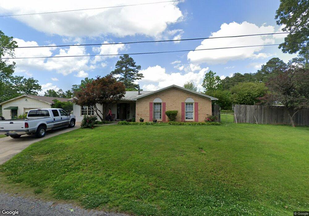
301 Stewart Rd Oneonta, AL 35121
Estimated Value: $171,000 - $212,000
4
Beds
2
Baths
1,530
Sq Ft
$126/Sq Ft
Est. Value
About This Home
This home is located at 301 Stewart Rd, Oneonta, AL 35121 and is currently estimated at $192,566, approximately $125 per square foot. 301 Stewart Rd is a home located in Blount County with nearby schools including Oneonta Elementary School, Oneonta Middle School, and Oneonta High School.
Ownership History
Date
Name
Owned For
Owner Type
Purchase Details
Closed on
Oct 26, 2011
Sold by
Putman Thomas R
Bought by
Putman Angelica
Current Estimated Value
Purchase Details
Closed on
Jun 11, 2008
Sold by
Deutsche Bank National Trust Company
Bought by
Putman Thomas R
Home Financials for this Owner
Home Financials are based on the most recent Mortgage that was taken out on this home.
Original Mortgage
$49,200
Interest Rate
6.08%
Mortgage Type
Purchase Money Mortgage
Purchase Details
Closed on
Sep 21, 2007
Sold by
Smith Robert H and Smith Tena D
Bought by
Empire Mortgage X Inc
Create a Home Valuation Report for This Property
The Home Valuation Report is an in-depth analysis detailing your home's value as well as a comparison with similar homes in the area
Home Values in the Area
Average Home Value in this Area
Purchase History
| Date | Buyer | Sale Price | Title Company |
|---|---|---|---|
| Putman Angelica | -- | -- | |
| Putman Thomas R | $61,500 | -- | |
| Empire Mortgage X Inc | $11,905 | -- |
Source: Public Records
Mortgage History
| Date | Status | Borrower | Loan Amount |
|---|---|---|---|
| Previous Owner | Putman Thomas R | $49,200 |
Source: Public Records
Tax History Compared to Growth
Tax History
| Year | Tax Paid | Tax Assessment Tax Assessment Total Assessment is a certain percentage of the fair market value that is determined by local assessors to be the total taxable value of land and additions on the property. | Land | Improvement |
|---|---|---|---|---|
| 2024 | $510 | $12,620 | $1,500 | $11,120 |
| 2023 | $510 | $13,520 | $1,500 | $12,020 |
| 2022 | $515 | $12,740 | $1,500 | $11,240 |
| 2021 | $394 | $10,040 | $1,500 | $8,540 |
| 2020 | $401 | $9,780 | $1,500 | $8,280 |
| 2019 | $382 | $9,780 | $1,500 | $8,280 |
| 2018 | $382 | $9,780 | $1,500 | $8,280 |
| 2017 | $342 | $8,880 | $0 | $0 |
| 2015 | -- | $9,240 | $0 | $0 |
| 2014 | -- | $9,800 | $0 | $0 |
| 2013 | -- | $9,860 | $0 | $0 |
Source: Public Records
Map
Nearby Homes
- 85 Trinity Ln
- 53660 US Hwy 231 S
- 209 Hudson Ave
- 10 Pine Cir
- 393 Central Ave
- 1 Grandview Dr
- 1011 Rose St
- 0 W Lakeshore Dr Unit 3-E 21417543
- 0 W Lakeshore Dr Unit 4 21411402
- 403 Central Ave
- 851 Underwood Ave
- 36 Pine Cir
- 104 Harris Ave
- 908 Ransome Dr
- 0 Sunshine Ave Unit 21427459
- 8 Fieldview Dr
- 703 2nd St S
- 907 Spruce Rd
- 102 Azalea Trail
- 909 Camellia Rd
- 509 Ransome Dr
- 302 Stewart Rd
- 507 Ransome Dr
- 507 1/2 Ransome Dr
- 698 Woodland Dr S
- 401 Stewart Rd
- 505 Reid Rd
- 608 Woodland Dr S
- 700 Woodland Dr S
- 510 Ransome Dr
- 703 Ransome Dr
- 48 Trinity Ln
- 58 Trinity Ln
- 70 Trinity Ln
- 88 Trinity Ln
- 57 Trinity Ln
- 47 Trinity Ln
- 29 Trinity Ln
- 67 Trinity Ln
- 95 Trinity Ln