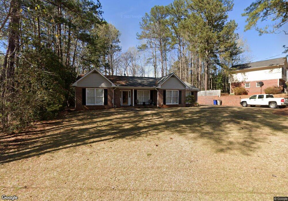
301 Valley Ct Lagrange, GA 30241
Estimated Value: $220,000 - $270,000
4
Beds
3
Baths
1,914
Sq Ft
$128/Sq Ft
Est. Value
About This Home
This home is located at 301 Valley Ct, Lagrange, GA 30241 and is currently estimated at $245,269, approximately $128 per square foot. 301 Valley Ct is a home located in Troup County with nearby schools including Franklin Forest Elementary School, Hollis Hand Elementary School, and Ethel W. Kight Elementary School.
Ownership History
Date
Name
Owned For
Owner Type
Purchase Details
Closed on
Jun 30, 1999
Sold by
John Alise
Bought by
Nelms David C
Current Estimated Value
Purchase Details
Closed on
Mar 1, 1995
Sold by
Joanne Joanne W and Joanne B
Bought by
John Alise
Purchase Details
Closed on
May 23, 1988
Sold by
Lagrange Investment Co
Bought by
Joanne Joanne W and Joanne B
Create a Home Valuation Report for This Property
The Home Valuation Report is an in-depth analysis detailing your home's value as well as a comparison with similar homes in the area
Home Values in the Area
Average Home Value in this Area
Purchase History
| Date | Buyer | Sale Price | Title Company |
|---|---|---|---|
| Nelms David C | $91,500 | -- | |
| John Alise | -- | -- | |
| Joanne Joanne W | $9,600 | -- |
Source: Public Records
Tax History Compared to Growth
Tax History
| Year | Tax Paid | Tax Assessment Tax Assessment Total Assessment is a certain percentage of the fair market value that is determined by local assessors to be the total taxable value of land and additions on the property. | Land | Improvement |
|---|---|---|---|---|
| 2024 | $2,011 | $75,720 | $10,000 | $65,720 |
| 2023 | $1,879 | $70,880 | $10,000 | $60,880 |
| 2022 | $1,800 | $66,480 | $10,000 | $56,480 |
| 2021 | $1,630 | $56,040 | $8,000 | $48,040 |
| 2020 | $1,630 | $56,040 | $8,000 | $48,040 |
| 2019 | $1,668 | $57,280 | $8,000 | $49,280 |
| 2018 | $1,425 | $49,248 | $4,968 | $44,280 |
| 2017 | $1,425 | $49,248 | $4,968 | $44,280 |
| 2016 | $1,405 | $48,563 | $4,968 | $43,595 |
| 2015 | $1,407 | $48,563 | $4,968 | $43,595 |
| 2014 | $1,340 | $46,269 | $4,968 | $41,301 |
| 2013 | -- | $48,857 | $4,968 | $43,889 |
Source: Public Records
Map
Nearby Homes
- 109 Dogwood Dr
- 706 N Harlem Cir
- 210 Hearthstone Dr
- 608 S Harlem Cir
- 606 S Harlem Cir
- 616 S Harlem Cir
- 618 S Harlem Cir
- 806 New Franklin Rd
- 600 S Harlem Cir
- 114 Briarcliff Rd
- 900 North St
- 131 Foch St
- 110 Russell St
- 121 Ct
- 204 Colonial St
- 600,606,608,616 S Harlem
- 400 S Page St
- 134 S Page St
- 305 Lenox Cir
- 105 Lenox Cir
- 303 Valley Ct
- 300 Valley Ct
- 100 Starmount Dr Unit LOT 105
- 100 Starmount Dr
- 302 Valley Ct
- 305 Valley Ct
- 304 Valley Ct
- 464 Hickory Terrace
- 102 Starmount Dr
- 102 Starmount Dr Unit LOT 104
- 466 Hickory Terrace Unit 32
- 306 Valley Ct
- 307 Valley Ct
- 0 Starmount Dr Unit 2064039-7682410
- 0 Starmount Dr Unit 7394673
- 0 Starmount Dr Unit 7394651
- 107 Starmount Dr
- 331 Laurel Ln
- 308 Valley Ct
- 468 Hickory Terrace