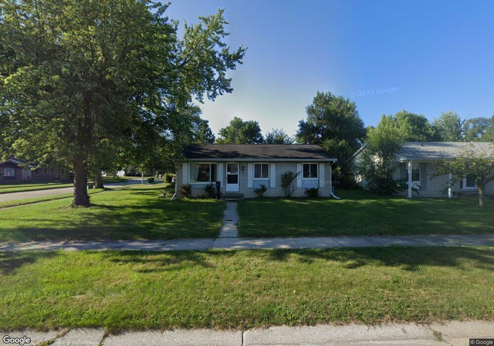
30117 Jamestown St Romulus, MI 48174
Estimated Value: $161,000 - $198,000
3
Beds
2
Baths
1,150
Sq Ft
$159/Sq Ft
Est. Value
About This Home
This home is located at 30117 Jamestown St, Romulus, MI 48174 and is currently estimated at $182,670, approximately $158 per square foot. 30117 Jamestown St is a home located in Wayne County with nearby schools including Halecreek Elementary School, Romulus Middle School, and Romulus Senior High School.
Ownership History
Date
Name
Owned For
Owner Type
Purchase Details
Closed on
Jun 2, 2021
Sold by
Skeith Delores
Bought by
Randall Kathleen M and Randall Roy C
Current Estimated Value
Home Financials for this Owner
Home Financials are based on the most recent Mortgage that was taken out on this home.
Original Mortgage
$108,007
Outstanding Balance
$97,787
Interest Rate
2.9%
Mortgage Type
FHA
Estimated Equity
$84,883
Purchase Details
Closed on
Aug 21, 2002
Sold by
Karkoski Bruce J
Bought by
Skeith Delores
Purchase Details
Closed on
Mar 23, 1999
Sold by
Bank Of America
Bought by
Karkoski Bruce J
Create a Home Valuation Report for This Property
The Home Valuation Report is an in-depth analysis detailing your home's value as well as a comparison with similar homes in the area
Home Values in the Area
Average Home Value in this Area
Purchase History
| Date | Buyer | Sale Price | Title Company |
|---|---|---|---|
| Randall Kathleen M | $110,000 | First American Title | |
| Skeith Delores | $107,000 | -- | |
| Karkoski Bruce J | -- | Multiple |
Source: Public Records
Mortgage History
| Date | Status | Borrower | Loan Amount |
|---|---|---|---|
| Open | Randall Kathleen M | $108,007 |
Source: Public Records
Tax History
| Year | Tax Paid | Tax Assessment Tax Assessment Total Assessment is a certain percentage of the fair market value that is determined by local assessors to be the total taxable value of land and additions on the property. | Land | Improvement |
|---|---|---|---|---|
| 2025 | $3,110 | $81,700 | $0 | $0 |
| 2024 | $3,078 | $75,100 | $0 | $0 |
| 2023 | $2,970 | $66,700 | $0 | $0 |
| 2022 | $3,478 | $61,200 | $0 | $0 |
| 2021 | $2,626 | $49,600 | $0 | $0 |
| 2020 | $2,580 | $48,300 | $0 | $0 |
| 2019 | $2,551 | $41,000 | $0 | $0 |
| 2018 | $1,922 | $31,800 | $0 | $0 |
| 2017 | $823 | $31,400 | $0 | $0 |
| 2016 | $2,312 | $32,700 | $0 | $0 |
| 2015 | $3,150 | $31,500 | $0 | $0 |
| 2013 | $3,140 | $34,000 | $0 | $0 |
| 2012 | $1,140 | $33,300 | $5,400 | $27,900 |
Source: Public Records
Map
Nearby Homes
- 30058 Halecreek St
- 15900 Sandburg St
- 15521 Brandt St
- 30455 Cherry Ave
- 16068 Middlebelt Rd
- 16110 Farnum St
- 30771 Halecreek St
- 00 Eureka Rd
- 15715 Merriman Rd
- 15654 Isabelle St
- 30620 Pennsylvania Rd
- 28567 Forest Dale St
- 29067 Cullen Dr Unit BLDG8
- 28510 Halecreek St
- 30930 Pennsylvania Rd Unit 8
- 15630 Harrison
- 15721 Harrison St
- 15777 Harrison
- 00000 Pennsylvania Rd
- 16913 Aberdeen Dr Unit 220
- 30129 Jamestown St
- 30170 Kipling St
- 30143 Jamestown St
- 30109 Kipling St
- 30123 Kipling St
- 30188 Kipling St
- 30118 Jamestown St
- 30106 Jamestown St
- 30130 Jamestown St
- 30157 Jamestown St
- 30202 Kipling St
- 30142 Jamestown St
- 30137 Kipling St
- 30040 Jamestown St
- 30169 Jamestown St
- 30052 Jamestown St
- 30218 Kipling St
- 30149 Kipling St
- 30173 Kipling St
- 15612 Sandburg St
Your Personal Tour Guide
Ask me questions while you tour the home.