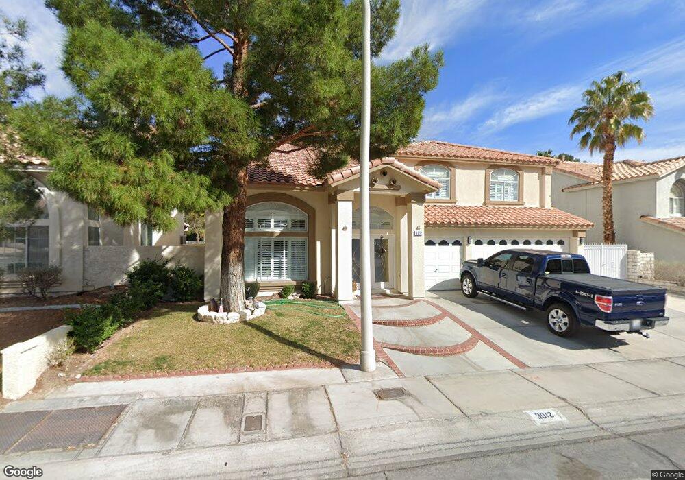
3012 Ocean Port Dr Las Vegas, NV 89117
The Section Seven NeighborhoodEstimated Value: $642,127 - $787,000
5
Beds
3
Baths
3,188
Sq Ft
$224/Sq Ft
Est. Value
About This Home
This home is located at 3012 Ocean Port Dr, Las Vegas, NV 89117 and is currently estimated at $712,782, approximately $223 per square foot. 3012 Ocean Port Dr is a home located in Clark County with nearby schools including M J Christensen Elementary School, Clifford J Lawrence Junior High School, and Bonanza High School.
Ownership History
Date
Name
Owned For
Owner Type
Purchase Details
Closed on
Nov 22, 2000
Sold by
Salas Claudio H and Salas Ines M
Bought by
Montoya Jose G and Montoya Martha R
Current Estimated Value
Home Financials for this Owner
Home Financials are based on the most recent Mortgage that was taken out on this home.
Original Mortgage
$226,000
Outstanding Balance
$83,158
Interest Rate
7.86%
Estimated Equity
$629,624
Purchase Details
Closed on
Jan 28, 1994
Sold by
American West Homes Inc
Bought by
Salas Claudio H and Salas Ines M
Home Financials for this Owner
Home Financials are based on the most recent Mortgage that was taken out on this home.
Original Mortgage
$150,000
Interest Rate
7.59%
Create a Home Valuation Report for This Property
The Home Valuation Report is an in-depth analysis detailing your home's value as well as a comparison with similar homes in the area
Home Values in the Area
Average Home Value in this Area
Purchase History
| Date | Buyer | Sale Price | Title Company |
|---|---|---|---|
| Montoya Jose G | $240,000 | Nevada Title Company | |
| Salas Claudio H | $212,000 | First American Title Company |
Source: Public Records
Mortgage History
| Date | Status | Borrower | Loan Amount |
|---|---|---|---|
| Open | Montoya Jose G | $226,000 | |
| Previous Owner | Salas Claudio H | $150,000 |
Source: Public Records
Tax History Compared to Growth
Tax History
| Year | Tax Paid | Tax Assessment Tax Assessment Total Assessment is a certain percentage of the fair market value that is determined by local assessors to be the total taxable value of land and additions on the property. | Land | Improvement |
|---|---|---|---|---|
| 2025 | $3,556 | $152,755 | $57,050 | $95,705 |
| 2024 | $3,453 | $152,755 | $57,050 | $95,705 |
| 2023 | $3,453 | $138,945 | $47,250 | $91,695 |
| 2022 | $3,675 | $120,643 | $36,750 | $83,893 |
| 2021 | $3,403 | $116,525 | $36,400 | $80,125 |
| 2020 | $3,157 | $112,457 | $32,900 | $79,557 |
| 2019 | $2,959 | $105,782 | $26,950 | $78,832 |
| 2018 | $2,823 | $102,279 | $26,600 | $75,679 |
| 2017 | $3,340 | $101,878 | $24,850 | $77,028 |
| 2016 | $2,643 | $94,559 | $17,500 | $77,059 |
| 2015 | $2,637 | $81,989 | $16,450 | $65,539 |
| 2014 | $2,560 | $75,772 | $8,750 | $67,022 |
Source: Public Records
Map
Nearby Homes
- 3040 Ocean Port Dr
- 9100 Shelter Cove Ct
- 9113 Anchor Cove Ct
- 3009 Periscope Ct
- 2913 Domino Way
- 9312 Angelfish Dr
- 9429 Abalone Way
- 9021 Feather River Ct
- 3120 Waterview Dr
- 3205 Bermuda Bay St
- 3220 Ventana Hills Dr
- 9028 Cypress Point Way
- 9105 Cypress Point Way
- 8924 Sail Bay Dr
- 9504 Cliff View Way
- 9305 Alameda Harbor Ave
- 2825 Waterview Dr
- 9013 Cypress Point Way
- 2712 Quail Roost Way
- 9548 Wooden Pier Way
- 3016 Ocean Port Dr
- 3008 Ocean Port Dr Unit 11A
- 3020 Ocean Port Dr
- 3004 Ocean Port Dr
- 3013 Ocean Port Dr
- 3024 Ocean Port Dr Unit 11A
- 3000 Ocean Port Dr
- 3017 Ocean Port Dr
- 3001 Ocean Port Dr
- 3009 Ocean Port Dr
- 9108 Dolphin Cove Ct
- 3028 Ocean Port Dr
- 9105 Dolphin Cove Ct
- 3005 Ocean Port Dr
- 9104 Dolphin Cove Ct
- 9108 Safeport Cove Ct
- 3012 High Tide Ct Unit 11B
- 3008 High Tide Ct
- 3004 High Tide Ct Unit 11B
- 9104 Safeport Cove Ct