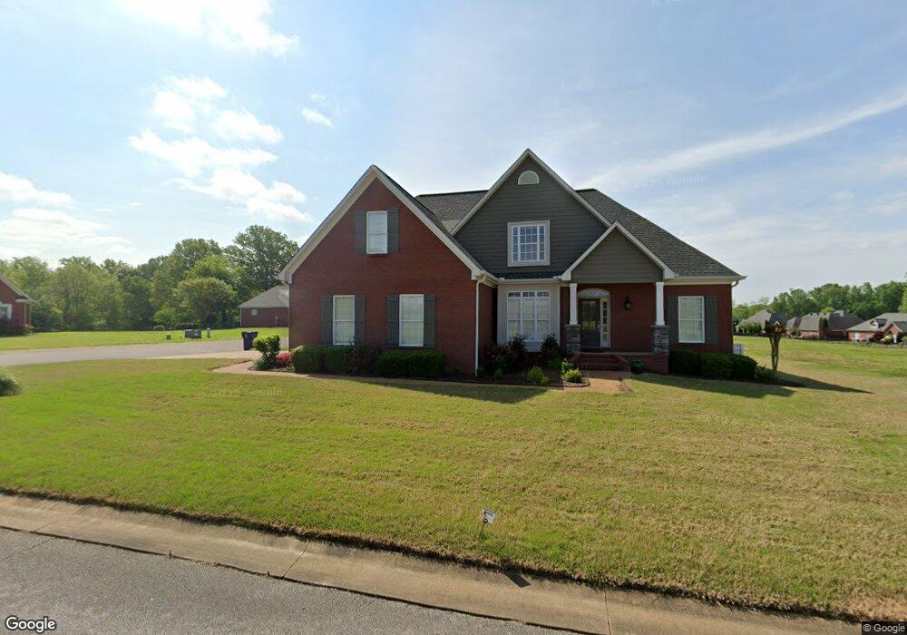
3012 Patrick Dr Corinth, MS 38834
Estimated Value: $336,000 - $383,000
Studio
1
Bath
3,006
Sq Ft
$122/Sq Ft
Est. Value
About This Home
This home is located at 3012 Patrick Dr, Corinth, MS 38834 and is currently estimated at $366,509, approximately $121 per square foot. 3012 Patrick Dr is a home with nearby schools including Corinth Elementary School, Corinth Middle School, and Corinth High School.
Ownership History
Date
Name
Owned For
Owner Type
Purchase Details
Closed on
Jun 26, 2017
Sold by
Strickland John and Strickland Elizabeth
Bought by
Vanjowers James Van and Jowers Michelle
Current Estimated Value
Home Financials for this Owner
Home Financials are based on the most recent Mortgage that was taken out on this home.
Original Mortgage
$289,240
Outstanding Balance
$239,543
Interest Rate
3.95%
Mortgage Type
New Conventional
Estimated Equity
$126,966
Purchase Details
Closed on
May 31, 2016
Sold by
Jessup Jennifer
Bought by
Strickland John and Strickland Elizabeth
Home Financials for this Owner
Home Financials are based on the most recent Mortgage that was taken out on this home.
Original Mortgage
$243,000
Interest Rate
3.61%
Mortgage Type
New Conventional
Create a Home Valuation Report for This Property
The Home Valuation Report is an in-depth analysis detailing your home's value as well as a comparison with similar homes in the area
Purchase History
| Date | Buyer | Sale Price | Title Company |
|---|---|---|---|
| Vanjowers James Van | -- | None Available | |
| Strickland John | -- | -- |
Source: Public Records
Mortgage History
| Date | Status | Borrower | Loan Amount |
|---|---|---|---|
| Open | Vanjowers James Van | $289,240 | |
| Previous Owner | Strickland John | $243,000 |
Source: Public Records
Tax History
| Year | Tax Paid | Tax Assessment Tax Assessment Total Assessment is a certain percentage of the fair market value that is determined by local assessors to be the total taxable value of land and additions on the property. | Land | Improvement |
|---|---|---|---|---|
| 2025 | $989 | $24,566 | $0 | $0 |
| 2024 | $10 | $20,916 | $0 | $0 |
| 2023 | $988 | $20,898 | $0 | $0 |
| 2022 | $988 | $20,898 | $0 | $0 |
| 2021 | $966 | $20,494 | $0 | $0 |
| 2020 | $954 | $20,278 | $0 | $0 |
| 2019 | $954 | $20,278 | $0 | $0 |
| 2018 | $981 | $20,278 | $0 | $0 |
| 2017 | $1,094 | $0 | $0 | $0 |
| 2016 | $988 | $0 | $0 | $0 |
| 2015 | -- | $0 | $0 | $0 |
| 2014 | -- | $0 | $0 | $0 |
Source: Public Records
Map
Nearby Homes
- 3285 Shadowood Ln
- 3500 Shiloh Ridge Rd
- 4607 N Harper Rd
- Lot# 1 N Shiloh Rd
- Lot# 2 N Shiloh Rd
- 4506 N Shiloh Rd
- 2102 Beauregard Park
- 4402 Dove Cove
- 3901 Worsham Dr
- 3001 N Haven Dr
- 0 Tract 6 Richman Dr
- 0 Tract 3 Richman Cir
- 0 Tract 2 Richman Cir
- 0 Tract 5 Richman Cir
- 0 Tract 1 Richman Cir
- 0 Tract 4 Richman Cir
- 4108 Forrest Rd
- 3115 N Hills Blvd
- Lot# 3 Bynum Dr
- 106 Afton Dr
- 4042 St Andrews
- 4042 Saint Andrews Cir
- 4038 Saint Andrews Cir
- 3008 Patrick Dr
- 4036 St Andrews Cr
- 4036 Saint Andrews Cir
- 4044 St Andrews
- 4001 Saint Andrews Cir
- 4005 Saint Andrews Cir
- 4046 Saint Andrews Cir
- 4003 Saint Andrews Cir
- 2002 Champion Dr
- 4007 Saint Andrews Cir
- 4030 Saint Andrews Cir
- 1999 Champion Dr
- 4053 Saint Andrews Cir
- 4045 Saint Andrews Cir
- 4009 Saint Andrews Cir
- 3002 Patrick Dr
- 4028 Saint Andrews Cir
Your Personal Tour Guide
Ask me questions while you tour the home.