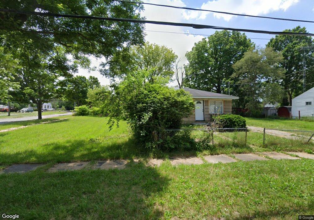
3013 N Vernon Ave Flint, MI 48506
Eastside NeighborhoodEstimated Value: $23,362 - $248,000
3
Beds
1
Bath
1,075
Sq Ft
$115/Sq Ft
Est. Value
About This Home
This home is located at 3013 N Vernon Ave, Flint, MI 48506 and is currently estimated at $123,341, approximately $114 per square foot. 3013 N Vernon Ave is a home located in Genesee County with nearby schools including Brownell STEM Academy, Richfield Public School Academy, and Flint Cultural Center Academy.
Ownership History
Date
Name
Owned For
Owner Type
Purchase Details
Closed on
Oct 22, 2025
Sold by
Peaceful Housing
Bought by
Stoldt Ryan
Current Estimated Value
Purchase Details
Closed on
Mar 12, 2024
Sold by
Genesee Cnty Land Bk Authority
Bought by
Peaceful Housing
Purchase Details
Closed on
Dec 20, 2012
Sold by
Cherry Deborah L
Bought by
Genesee County Land Bank
Purchase Details
Closed on
Nov 1, 2005
Sold by
Hull John and Hull Lisa
Bought by
The Smith Family Trust
Purchase Details
Closed on
Jun 29, 2001
Sold by
Simpson Olione D
Bought by
Sutton John W and Sutton Joan C
Create a Home Valuation Report for This Property
The Home Valuation Report is an in-depth analysis detailing your home's value as well as a comparison with similar homes in the area
Home Values in the Area
Average Home Value in this Area
Purchase History
| Date | Buyer | Sale Price | Title Company |
|---|---|---|---|
| Stoldt Ryan | -- | None Listed On Document | |
| Peaceful Housing | -- | None Listed On Document | |
| Peaceful Housing | -- | None Listed On Document | |
| Genesee County Land Bank | -- | None Available | |
| The Smith Family Trust | -- | Centennial Title Co | |
| The Smith Family Trust | $5,000 | Centennial Title Co | |
| Sutton John W | $18,000 | -- | |
| Sutton John W | -- | -- |
Source: Public Records
Tax History
| Year | Tax Paid | Tax Assessment Tax Assessment Total Assessment is a certain percentage of the fair market value that is determined by local assessors to be the total taxable value of land and additions on the property. | Land | Improvement |
|---|---|---|---|---|
| 2025 | -- | $2,700 | $0 | $0 |
| 2024 | -- | $0 | $0 | $0 |
| 2023 | -- | $0 | $0 | $0 |
| 2022 | $0 | $0 | $0 | $0 |
| 2021 | $0 | $0 | $0 | $0 |
| 2020 | $0 | $0 | $0 | $0 |
| 2019 | $0 | $0 | $0 | $0 |
| 2018 | $0 | $0 | $0 | $0 |
| 2017 | $0 | $0 | $0 | $0 |
| 2016 | $0 | $0 | $0 | $0 |
| 2015 | -- | $0 | $0 | $0 |
| 2014 | -- | $0 | $0 | $0 |
| 2012 | -- | $8,200 | $0 | $0 |
Source: Public Records
Map
Nearby Homes
- 2217 Maryland Ave
- 1805 Montana Ave
- 1733 Oklahoma Ave
- 1826 Dakota Ave
- 1730 Oklahoma Ave
- 1656 Montana Ave
- 2506 Arlington Ave
- 1623 Montana Ave
- 1721 New York Ave
- 1629 New York Ave
- 2426 Hoff St
- 2321 Levern St
- 1526 Montana Ave
- 1518 Leith St
- 1526 Arizona Ave
- 1510 Utah Ave
- 1805 Bennett Ave
- 1422 Leith St
- 3010 Wyoming Ave
- 1445 Maryland Ave
Your Personal Tour Guide
Ask me questions while you tour the home.