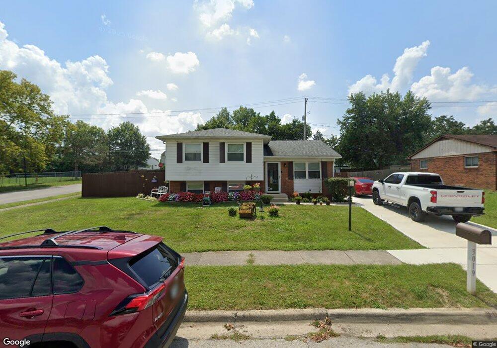
3019 Rivercliff Rd Columbus, OH 43223
Riverbend NeighborhoodEstimated Value: $199,000 - $238,000
3
Beds
1
Bath
1,055
Sq Ft
$204/Sq Ft
Est. Value
About This Home
This home is located at 3019 Rivercliff Rd, Columbus, OH 43223 and is currently estimated at $215,005, approximately $203 per square foot. 3019 Rivercliff Rd is a home located in Franklin County with nearby schools including James A Harmon Elementary School, Franklin Woods Intermediate School, and Finland Middle School.
Ownership History
Date
Name
Owned For
Owner Type
Purchase Details
Closed on
Aug 8, 2022
Sold by
Pilkington Barbara
Bought by
Pilkington-Jarrell Angela and Jarrell Carlous
Current Estimated Value
Home Financials for this Owner
Home Financials are based on the most recent Mortgage that was taken out on this home.
Original Mortgage
$166,920
Outstanding Balance
$158,714
Interest Rate
5.51%
Mortgage Type
FHA
Estimated Equity
$56,291
Purchase Details
Closed on
Sep 26, 2006
Sold by
Perry Sheri and Perry Kenneth
Bought by
Pilkington Gregory and Pilkington Barbara
Purchase Details
Closed on
Mar 8, 1989
Bought by
Pilkington Donald R
Create a Home Valuation Report for This Property
The Home Valuation Report is an in-depth analysis detailing your home's value as well as a comparison with similar homes in the area
Home Values in the Area
Average Home Value in this Area
Purchase History
| Date | Buyer | Sale Price | Title Company |
|---|---|---|---|
| Pilkington-Jarrell Angela | $170,000 | Valmer Land Title | |
| Pilkington Gregory | $60,000 | None Available | |
| Pilkington Donald R | -- | -- |
Source: Public Records
Mortgage History
| Date | Status | Borrower | Loan Amount |
|---|---|---|---|
| Open | Pilkington-Jarrell Angela | $166,920 |
Source: Public Records
Tax History
| Year | Tax Paid | Tax Assessment Tax Assessment Total Assessment is a certain percentage of the fair market value that is determined by local assessors to be the total taxable value of land and additions on the property. | Land | Improvement |
|---|---|---|---|---|
| 2025 | $2,593 | $71,120 | $18,060 | $53,060 |
| 2024 | $2,593 | $71,120 | $18,060 | $53,060 |
| 2023 | $2,547 | $71,120 | $18,060 | $53,060 |
| 2022 | $2,229 | $45,680 | $12,220 | $33,460 |
| 2021 | $2,274 | $45,680 | $12,220 | $33,460 |
| 2020 | $2,261 | $45,680 | $12,220 | $33,460 |
| 2019 | $2,105 | $37,530 | $10,190 | $27,340 |
| 2018 | $1,961 | $37,530 | $10,190 | $27,340 |
| 2017 | $2,086 | $37,530 | $10,190 | $27,340 |
| 2016 | $1,826 | $30,180 | $5,290 | $24,890 |
| 2015 | $1,826 | $30,180 | $5,290 | $24,890 |
| 2014 | $1,828 | $30,180 | $5,290 | $24,890 |
| 2013 | $1,007 | $33,530 | $5,880 | $27,650 |
Source: Public Records
Map
Nearby Homes
- 2112 Sondra Ln
- 0 Glencreek Rd
- 3116 Musket Ridge Dr
- 2255 Harrisburg Pike
- 2103 Keller Place W
- 1638 Tall Meadows Dr
- 1605 Greenville Rd
- 3407 Western Hill Rd
- 2500 Harrisburg Pike Unit Lot 8
- 1657 Ripplebrook Rd
- 2430 Chateau St
- 2937 Rundell Dr
- 2364 Nedra St
- 1360 Hafton Woods Dr
- 2436 Onyx Ct
- 2407 Bluff Run Dr
- 1335 Hafton Woods Dr
- 2856 Chesfield Dr
- 3816 Miltonsburg Dr
- 2870 Chesfield Dr
- 3027 Rivercliff Rd
- 3005 Rivercliff Rd
- 3020 Rivercliff Rd
- 3035 Rivercliff Rd
- 2997 Rivercliff Rd
- 2072 Sondra Ln
- 2064 Sondra Ln
- 1848 Creekside Dr
- 2080 Sondra Ln
- 2056 Sondra Ln
- 1831 Creekside Dr
- 1831 Creekside Dr Unit ROCK
- 2088 Sondra Ln
- 2088 Sondra Ln Unit 115
- 3032 Rivercliff Rd
- 2985 Rivercliff Rd
- 2048 Sondra Ln
- 3039 Rivercliff Rd
- 1840 Creekside Dr
- 2096 Sondra Ln
Your Personal Tour Guide
Ask me questions while you tour the home.