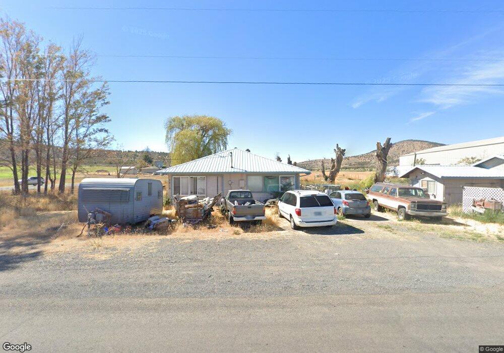
3019 SW Jericho Ln Culver, OR 97734
Estimated Value: $442,220 - $688,000
3
Beds
2
Baths
2,368
Sq Ft
$239/Sq Ft
Est. Value
About This Home
This home is located at 3019 SW Jericho Ln, Culver, OR 97734 and is currently estimated at $565,110, approximately $238 per square foot. 3019 SW Jericho Ln is a home located in Jefferson County with nearby schools including Culver Elementary School, Culver Middle School, and Culver High School.
Ownership History
Date
Name
Owned For
Owner Type
Purchase Details
Closed on
May 12, 2010
Sold by
The Bank Of New York Mellon
Bought by
Heath Samuel Lee
Current Estimated Value
Home Financials for this Owner
Home Financials are based on the most recent Mortgage that was taken out on this home.
Original Mortgage
$117,370
Interest Rate
4.51%
Mortgage Type
VA
Purchase Details
Closed on
Nov 15, 2006
Sold by
Gibson Patricia M
Bought by
Hilliard William
Home Financials for this Owner
Home Financials are based on the most recent Mortgage that was taken out on this home.
Original Mortgage
$45,800
Interest Rate
6.36%
Mortgage Type
Credit Line Revolving
Create a Home Valuation Report for This Property
The Home Valuation Report is an in-depth analysis detailing your home's value as well as a comparison with similar homes in the area
Purchase History
| Date | Buyer | Sale Price | Title Company |
|---|---|---|---|
| Heath Samuel Lee | -- | Jefferson County Title Compa | |
| Hilliard William | $229,000 | Amerititle |
Source: Public Records
Mortgage History
| Date | Status | Borrower | Loan Amount |
|---|---|---|---|
| Previous Owner | Heath Samuel Lee | $117,370 | |
| Previous Owner | Hilliard William | $45,800 | |
| Previous Owner | Hilliard William | $183,200 |
Source: Public Records
Tax History
| Year | Tax Paid | Tax Assessment Tax Assessment Total Assessment is a certain percentage of the fair market value that is determined by local assessors to be the total taxable value of land and additions on the property. | Land | Improvement |
|---|---|---|---|---|
| 2025 | $2,990 | $197,580 | -- | -- |
| 2024 | $2,910 | $191,830 | -- | -- |
| 2023 | $2,726 | $186,250 | $0 | $0 |
| 2022 | $2,652 | $180,830 | $0 | $0 |
| 2021 | $2,555 | $175,570 | $0 | $0 |
| 2020 | $2,442 | $170,460 | $0 | $0 |
| 2019 | $2,375 | $165,500 | $0 | $0 |
| 2018 | $2,295 | $160,680 | $0 | $0 |
| 2017 | $2,250 | $156,000 | $0 | $0 |
| 2016 | $2,255 | $151,460 | $0 | $0 |
| 2015 | $2,081 | $147,050 | $0 | $0 |
| 2014 | $2,081 | $142,770 | $0 | $0 |
| 2013 | -- | $138,620 | $0 | $0 |
Source: Public Records
Map
Nearby Homes
- 0 SW Wanker Unit 556217903
- 0 SW Wanker Unit 2200 220209349
- 822 Scenic Loop
- 0 Scenic Loop Unit 10300, Lot 17
- 721 Mountain Ridge Dr
- 326 E Sage Ln
- 514 Scenic Loop
- 213 E Sage Ln
- 430 E D St
- 405 E D St
- 339 Timothy Dr
- 311 Geneva St
- 410 2nd Ave
- 264 Center Ridge Dr
- 2660 SW Highland Ln
- 7626 SW Bear Dr
- 10879 SW Mintken Rd
- 0 SW Mintken Ln Unit 2100
- 5955 SW Bozarth Ln
- 2551 SW Ford Ln
Your Personal Tour Guide
Ask me questions while you tour the home.