Estimated Value: $298,756 - $365,000
3
Beds
1
Bath
1,887
Sq Ft
$175/Sq Ft
Est. Value
About This Home
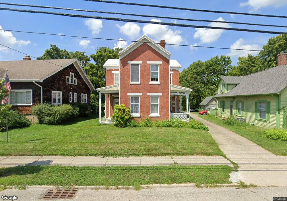
This home is located at 302 E Main St, Mason, OH 45040 and is currently estimated at $329,439, approximately $174 per square foot. 302 E Main St is a home located in Warren County with nearby schools including Mason Intermediate Elementary School, Mason Middle School, and William Mason High School.
Ownership History
Date
Name
Owned For
Owner Type
Purchase Details
Closed on
Aug 13, 2008
Sold by
Stevens Floyd D and Stevens Lillian R
Bought by
Stevens Floyd D and Stevens Lillian R
Current Estimated Value
Home Financials for this Owner
Home Financials are based on the most recent Mortgage that was taken out on this home.
Original Mortgage
$98,000
Interest Rate
6.42%
Mortgage Type
New Conventional
Create a Home Valuation Report for This Property
The Home Valuation Report is an in-depth analysis detailing your home's value as well as a comparison with similar homes in the area
Home Values in the Area
Average Home Value in this Area
Purchase History
| Date | Buyer | Sale Price | Title Company |
|---|---|---|---|
| Stevens Floyd D | -- | Concord Title Agency Inc |
Source: Public Records
Mortgage History
| Date | Status | Borrower | Loan Amount |
|---|---|---|---|
| Previous Owner | Stevens Floyd D | $98,000 |
Source: Public Records
Tax History
| Year | Tax Paid | Tax Assessment Tax Assessment Total Assessment is a certain percentage of the fair market value that is determined by local assessors to be the total taxable value of land and additions on the property. | Land | Improvement |
|---|---|---|---|---|
| 2025 | $3,408 | $93,610 | $36,380 | $57,230 |
| 2024 | $3,408 | $93,610 | $36,380 | $57,230 |
| 2023 | $2,882 | $68,603 | $17,899 | $50,704 |
| 2022 | $2,845 | $68,604 | $17,899 | $50,705 |
| 2021 | $2,695 | $68,604 | $17,899 | $50,705 |
| 2020 | $2,470 | $55,776 | $14,553 | $41,223 |
| 2019 | $2,272 | $55,776 | $14,553 | $41,223 |
| 2018 | $2,279 | $55,776 | $14,553 | $41,223 |
| 2017 | $2,345 | $53,900 | $14,242 | $39,659 |
| 2016 | $2,376 | $53,169 | $14,242 | $38,927 |
| 2015 | $2,381 | $53,169 | $14,242 | $38,927 |
| 2014 | $2,465 | $51,620 | $13,830 | $37,790 |
| 2013 | $2,470 | $54,330 | $14,550 | $39,780 |
Source: Public Records
Map
Nearby Homes
- 308 E Main St
- 306 E Main St
- 304 E Main St
- 107 Cowan Dr
- 5130 Franklin Park St
- 5173 Franklin Park St
- 4922 Bordeaux Ln Unit 4922
- 404 W Church St
- 200 Woodland Rd
- 4897 Bordeaux Ln Unit 4897
- 4943 Isaac Ln
- 4782 Bordeaux Ln
- 4776 Bordeaux Ln
- 4268 Fontenay
- 4734 Margaret Ct
- 4684 Court Yard Dr
- 600 W Church St
- 3 Carnell Place
- 4163 Spyglass Hill Unit 4163
- 4521 Springhouse Ct
- 300 E Main St
- 304 E Main St Unit A
- 306 E Main St Unit A
- 212 E Main St
- 210 E Main St
- 308 E Main St Unit A
- 310 E Main St
- 310 E Main St Unit A
- 312 E Main St
- 312 E Main St Unit A
- 208 E Main St
- 305 E Main St
- 314 E Main St Unit A
- 307 E Main St
- 206 E Main St
- 209 E Main St
- 311 E Main St
- 201 E Main St
- 102 Cowan Dr
- 316 E Main St
Your Personal Tour Guide
Ask me questions while you tour the home.