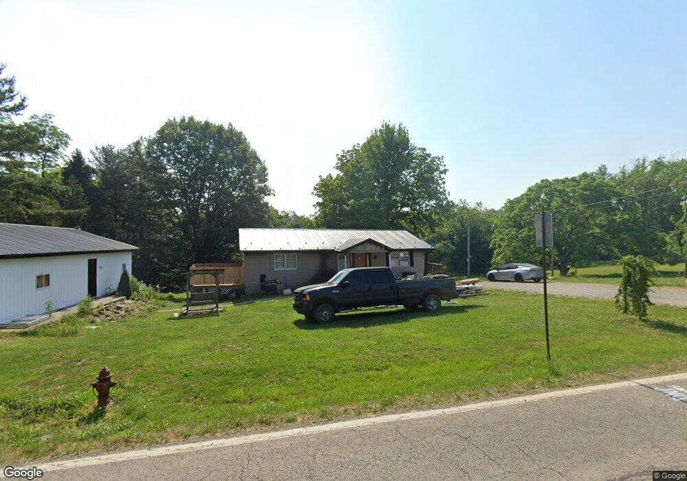
302 E State Route 757 Dr Somerset, OH 43783
Estimated Value: $288,000 - $337,000
2
Beds
2
Baths
1,344
Sq Ft
$231/Sq Ft
Est. Value
About This Home
This home is located at 302 E State Route 757 Dr, Somerset, OH 43783 and is currently estimated at $310,308, approximately $230 per square foot. 302 E State Route 757 Dr is a home with nearby schools including Sheridan High School and Holy Trinity Elementary School.
Ownership History
Date
Name
Owned For
Owner Type
Purchase Details
Closed on
Oct 9, 2019
Sold by
Watkins Robert L
Bought by
Theisen Jordan and Theisen Alexis
Current Estimated Value
Home Financials for this Owner
Home Financials are based on the most recent Mortgage that was taken out on this home.
Original Mortgage
$156,950
Interest Rate
3.6%
Mortgage Type
New Conventional
Purchase Details
Closed on
Jan 22, 2014
Sold by
Masterson Gloria N
Bought by
Watkins Robert L
Home Financials for this Owner
Home Financials are based on the most recent Mortgage that was taken out on this home.
Original Mortgage
$160,240
Interest Rate
4.24%
Mortgage Type
FHA
Create a Home Valuation Report for This Property
The Home Valuation Report is an in-depth analysis detailing your home's value as well as a comparison with similar homes in the area
Home Values in the Area
Average Home Value in this Area
Purchase History
| Date | Buyer | Sale Price | Title Company |
|---|---|---|---|
| Theisen Jordan | $172,000 | Amrock Inc | |
| Watkins Robert L | $95,000 | None Available |
Source: Public Records
Mortgage History
| Date | Status | Borrower | Loan Amount |
|---|---|---|---|
| Previous Owner | Theisen Jordan | $156,950 | |
| Previous Owner | Watkins Robert L | $160,240 |
Source: Public Records
Tax History Compared to Growth
Tax History
| Year | Tax Paid | Tax Assessment Tax Assessment Total Assessment is a certain percentage of the fair market value that is determined by local assessors to be the total taxable value of land and additions on the property. | Land | Improvement |
|---|---|---|---|---|
| 2024 | $2,734 | $75,090 | $10,400 | $64,690 |
| 2023 | $2,734 | $75,070 | $10,380 | $64,690 |
| 2022 | $2,672 | $58,910 | $6,650 | $52,260 |
| 2021 | $2,400 | $58,910 | $6,650 | $52,260 |
| 2020 | $2,400 | $58,910 | $6,650 | $52,260 |
| 2019 | $2,098 | $51,650 | $6,380 | $45,270 |
| 2018 | $2,137 | $51,650 | $6,380 | $45,270 |
| 2017 | $2,029 | $51,650 | $6,380 | $45,270 |
| 2016 | $2,152 | $53,390 | $6,760 | $46,630 |
| 2015 | $2,150 | $53,390 | $6,760 | $46,630 |
| 2014 | $2,123 | $53,390 | $6,760 | $46,630 |
| 2013 | $2,156 | $53,390 | $6,760 | $46,630 |
| 2012 | -- | $53,390 | $6,760 | $46,630 |
Source: Public Records
Map
Nearby Homes
- 8151 Township Road 68 NW
- 101 Shady Ln
- 212 N Market St
- 403 N Columbus St
- 105 S Columbus St
- 300 E Main St
- 3783 U S 22
- 7575 Township Road 58 NE
- 5475 Rush Creek Rd NW
- 10705 Township Road 92
- 4190 State Route 669 NE
- 0 Toll Gate Rd
- 4486 Cooperriders Rd NW
- 2128 County Road 51
- 5930 U S 22
- 11284 State Route 668 N
- 4190 Township Road 143 NE
- 6662 Township Road 98
- 5353 Buckeye Valley Rd NE
- 0 Sheridan Dr Rd NW
- 300 E North Dr
- 300 E State Route 757 Dr
- 8142 State Route 757 NW
- 250 N Columbus St
- 0 Ohio 757
- 254 N Columbus St
- 256 N Columbus St
- 249 N Columbus St
- 248 N Columbus St
- 245 N Columbus St
- 246 N Columbus St
- 243 N Columbus St
- 300 North Dr
- 301 High St
- 244 N Columbus St
- 0 High St Unit 225006832
- 242 N Columbus St
- 251 N Market St
- 239 N Columbus St
- 240 N Columbus St