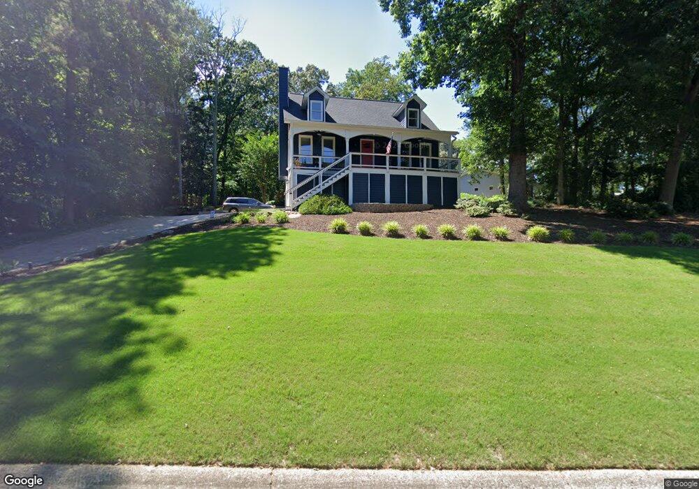
302 Knotts Cir Unit 1 Woodstock, GA 30188
Estimated Value: $594,000
4
Beds
3
Baths
2,678
Sq Ft
$222/Sq Ft
Est. Value
About This Home
This home is located at 302 Knotts Cir Unit 1, Woodstock, GA 30188 and is currently estimated at $594,000, approximately $221 per square foot. 302 Knotts Cir Unit 1 is a home located in Cherokee County with nearby schools including Arnold Mill Elementary School, Mill Creek Middle School, and River Ridge High School.
Ownership History
Date
Name
Owned For
Owner Type
Purchase Details
Closed on
Nov 9, 2022
Sold by
Sammons Jeffrey Hastings
Bought by
Baker Aaron Michael and Baker Noel Christine
Current Estimated Value
Home Financials for this Owner
Home Financials are based on the most recent Mortgage that was taken out on this home.
Original Mortgage
$280,900
Outstanding Balance
$243,859
Interest Rate
6.36%
Mortgage Type
New Conventional
Estimated Equity
$350,141
Purchase Details
Closed on
Jul 28, 2004
Sold by
Andrews Peggy O
Bought by
Sammons Lisa M
Home Financials for this Owner
Home Financials are based on the most recent Mortgage that was taken out on this home.
Original Mortgage
$159,000
Interest Rate
6.22%
Purchase Details
Closed on
May 14, 1996
Sold by
Cayce Charles Kathryn
Bought by
Andrews Keith Peggy
Create a Home Valuation Report for This Property
The Home Valuation Report is an in-depth analysis detailing your home's value as well as a comparison with similar homes in the area
Home Values in the Area
Average Home Value in this Area
Purchase History
| Date | Buyer | Sale Price | Title Company |
|---|---|---|---|
| Baker Aaron Michael | $530,000 | -- | |
| Sammons Lisa M | $191,500 | -- | |
| Andrews Keith Peggy | $131,000 | -- |
Source: Public Records
Mortgage History
| Date | Status | Borrower | Loan Amount |
|---|---|---|---|
| Open | Baker Aaron Michael | $280,900 | |
| Previous Owner | Sammons Lisa M | $159,000 | |
| Closed | Andrews Keith Peggy | $0 |
Source: Public Records
Tax History Compared to Growth
Tax History
| Year | Tax Paid | Tax Assessment Tax Assessment Total Assessment is a certain percentage of the fair market value that is determined by local assessors to be the total taxable value of land and additions on the property. | Land | Improvement |
|---|---|---|---|---|
| 2025 | $4,764 | $196,496 | $37,200 | $159,296 |
| 2024 | $4,697 | $194,944 | $37,200 | $157,744 |
| 2023 | $4,030 | $183,912 | $34,400 | $149,512 |
| 2022 | $3,463 | $131,776 | $30,000 | $101,776 |
| 2021 | $3,157 | $111,216 | $24,000 | $87,216 |
| 2020 | $2,843 | $100,056 | $19,600 | $80,456 |
| 2019 | $2,867 | $100,880 | $19,600 | $81,280 |
| 2018 | $2,620 | $91,640 | $19,600 | $72,040 |
| 2017 | $2,421 | $218,000 | $16,800 | $70,400 |
| 2016 | $2,421 | $207,900 | $16,800 | $66,360 |
| 2015 | $2,226 | $189,300 | $13,200 | $62,520 |
| 2014 | $2,036 | $172,800 | $13,200 | $55,920 |
Source: Public Records
Map
Nearby Homes
- 920 Lucky Ln
- 601 Cork St
- 424 Loblolly St
- 126 Heron Crossing
- 403 Heron Landing
- 106 Pioneer Dr
- 130 Cherecobb Dr
- 422 Stovall Place
- 421 Stovall Place
- 454 Mountain View Ln
- 3465 Township Ridge Point
- 607 Tall Timbers
- 441 Mountain View Ln Unit 371
- 313 Derrymore Dr
- 415 Mountain View Ln
- 1070 Daventry Crossing
- 502 Oxeye Dr
- 114 Knotts Landing Dr
- 304 Knotts Cir
- 201 Bowline Ct
- 116 Knotts Landing Dr
- 0 Bowline Ct Unit 7255777
- 0 Bowline Ct
- 404 Half Hitch Ct Unit 1
- 203 Bowline Ct
- 406 Half Hitch Ct
- 303 Knotts Cir
- 111 Knotts Landing Dr
- 402 Half Hitch Ct
- 113 Knotts Landing Dr
- 305 Knotts Cir
- 0 Knotts Landing Dr Unit 7237453
- 0 Knotts Landing Dr Unit 8373507
- 0 Knotts Landing Dr Unit 8286278
- 109 Knotts Landing Dr
- 205 Bowline Ct Unit 1
- 405 Half Hitch Ct