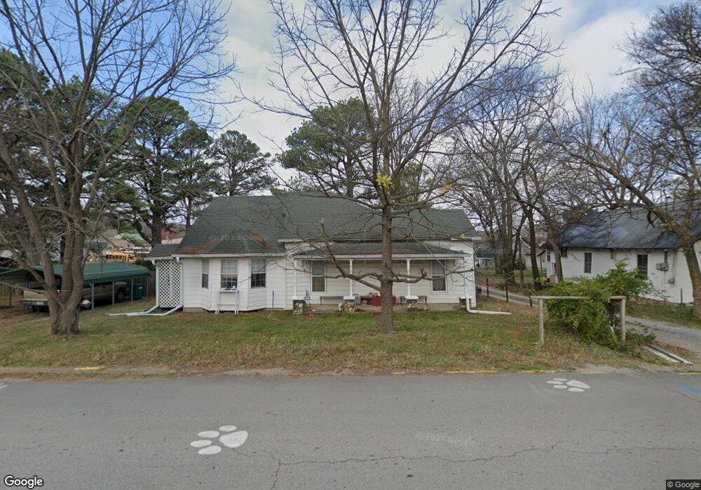
302 Main St West Fork, AR 72774
Estimated Value: $153,177 - $224,000
Studio
1
Bath
1,352
Sq Ft
$143/Sq Ft
Est. Value
About This Home
This home is located at 302 Main St, West Fork, AR 72774 and is currently estimated at $192,794, approximately $142 per square foot. 302 Main St is a home located in Washington County with nearby schools including West Fork Elementary School, West Fork Middle School, and West Fork High School.
Ownership History
Date
Name
Owned For
Owner Type
Purchase Details
Closed on
Jan 23, 2026
Sold by
Cline Joseph O and Cline Mae
Bought by
Cline Joseph O and Cline Mae
Current Estimated Value
Purchase Details
Closed on
Dec 27, 1995
Bought by
Emerson Ernest and Emerson Cline,
Purchase Details
Closed on
Oct 18, 1995
Bought by
Emerson Ernest S and P.O. Box 74
Purchase Details
Closed on
Dec 3, 1986
Bought by
Emerson Ernest S and P.O. Box 74
Purchase Details
Closed on
Dec 2, 1986
Bought by
Sullivan Shirley
Purchase Details
Closed on
Nov 17, 1986
Bought by
Rieff Rieff K and Rieff R
Purchase Details
Closed on
Jan 1, 1985
Bought by
Bilbrey, Larry & Trustee
Create a Home Valuation Report for This Property
The Home Valuation Report is an in-depth analysis detailing your home's value as well as a comparison with similar homes in the area
Home Values in the Area
Average Home Value in this Area
Purchase History
| Date | Buyer | Sale Price | Title Company |
|---|---|---|---|
| Cline Joseph O | -- | None Listed On Document | |
| Emerson Ernest | $26,000 | -- | |
| Emerson Ernest S | -- | -- | |
| Emerson Ernest S | -- | -- | |
| Sullivan Shirley | -- | -- | |
| Rieff Rieff K | -- | -- | |
| Bilbrey, Larry & Trustee | -- | -- |
Source: Public Records
Tax History
| Year | Tax Paid | Tax Assessment Tax Assessment Total Assessment is a certain percentage of the fair market value that is determined by local assessors to be the total taxable value of land and additions on the property. | Land | Improvement |
|---|---|---|---|---|
| 2025 | -- | $24,530 | $7,000 | $17,530 |
| 2024 | $83 | $24,530 | $7,000 | $17,530 |
| 2023 | $161 | $24,530 | $7,000 | $17,530 |
| 2022 | $211 | $16,640 | $4,250 | $12,390 |
| 2021 | $211 | $16,640 | $4,250 | $12,390 |
| 2020 | $211 | $16,640 | $4,250 | $12,390 |
| 2019 | $211 | $12,710 | $3,300 | $9,410 |
| 2018 | $236 | $12,710 | $3,300 | $9,410 |
| 2017 | $219 | $12,710 | $3,300 | $9,410 |
| 2016 | $219 | $12,710 | $3,300 | $9,410 |
| 2015 | $219 | $12,710 | $3,300 | $9,410 |
| 2014 | $179 | $10,244 | $2,750 | $7,494 |
Source: Public Records
Map
Nearby Homes
- 224 Maple Ave
- 0000 Highway 170
- 185 Wheeler St
- 163 Wheeler St
- 327 W Smith St
- 385 W Smith St
- 365 W Smith St
- 353 W Smith St
- 0 W Smith St Unit 1334508
- 222 Rivendale Dr
- 338 Hidden Creek Place
- 260 Culp Trail
- 13582 S Highway 170
- 846 James Place
- 815 James Place
- 696 E Thornstone Ave
- 13653 W Mountain Rd
- 67 S Red Oak Ave
- 294 W Main St
- 294 Main St
- 314 Main St
- 259 Mcknight Ave
- 288 Main St
- 295 McDonald St
- 285 Mcknight Ave
- 253 Mcknight Ave
- Box317 Low Gap Rd
- 11084 Pierce Rd
- 20064 Cove Creek Rd
- 0 W 39 Ac - 156 Hwy Unit 613013
- 12.18 Ac W 156 Hwy
- 11195 W 156 Hwy
- 12417 Green Plastic Rd
- 301 McDonald St
- 247 Mcknight Ave
- 254 Mcknight Ave
- 305 McDonald St
- 250 Mcknight Ave
Your Personal Tour Guide
Ask me questions while you tour the home.