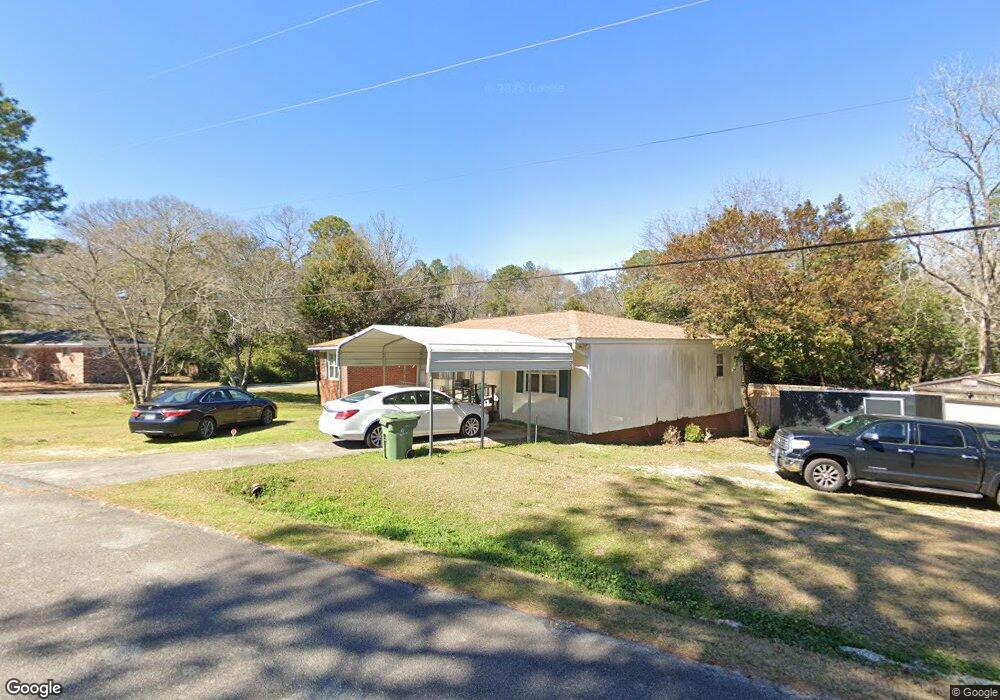
302 Mauk Cir Warner Robins, GA 31093
Estimated Value: $153,000 - $180,000
3
Beds
2
Baths
1,417
Sq Ft
$118/Sq Ft
Est. Value
About This Home
This home is located at 302 Mauk Cir, Warner Robins, GA 31093 and is currently estimated at $166,845, approximately $117 per square foot. 302 Mauk Cir is a home located in Houston County with nearby schools including Westside Elementary School, Northside Middle School, and Northside High School.
Ownership History
Date
Name
Owned For
Owner Type
Purchase Details
Closed on
Oct 31, 2006
Sold by
Meadows Sheila H
Bought by
Bowen Cynthia F
Current Estimated Value
Home Financials for this Owner
Home Financials are based on the most recent Mortgage that was taken out on this home.
Original Mortgage
$98,455
Outstanding Balance
$58,433
Interest Rate
6.27%
Mortgage Type
FHA
Estimated Equity
$108,412
Purchase Details
Closed on
Feb 1, 1987
Sold by
Hall Maye H Estate
Bought by
Hall George M
Purchase Details
Closed on
Feb 2, 1978
Sold by
Hall George M
Bought by
Hall George M and Hall Maye H
Purchase Details
Closed on
Nov 12, 1969
Sold by
Rogers Jessica B
Bought by
Hall George M
Purchase Details
Closed on
Oct 31, 1969
Sold by
Hildreth Douglas W and Hildreth Eva L
Bought by
Rogers Jessica B
Purchase Details
Closed on
Dec 28, 1967
Sold by
Devore Roy E
Bought by
Heldreth Douglas W and Heldreth Eva L
Purchase Details
Closed on
Aug 4, 1966
Sold by
Pike David F
Bought by
Devore Roy E
Create a Home Valuation Report for This Property
The Home Valuation Report is an in-depth analysis detailing your home's value as well as a comparison with similar homes in the area
Home Values in the Area
Average Home Value in this Area
Purchase History
| Date | Buyer | Sale Price | Title Company |
|---|---|---|---|
| Bowen Cynthia F | $100,000 | None Available | |
| Hall George M | -- | -- | |
| Hall George M | -- | -- | |
| Hall George M | -- | -- | |
| Rogers Jessica B | -- | -- | |
| Heldreth Douglas W | -- | -- | |
| Devore Roy E | -- | -- |
Source: Public Records
Mortgage History
| Date | Status | Borrower | Loan Amount |
|---|---|---|---|
| Open | Bowen Cynthia F | $98,455 |
Source: Public Records
Tax History Compared to Growth
Tax History
| Year | Tax Paid | Tax Assessment Tax Assessment Total Assessment is a certain percentage of the fair market value that is determined by local assessors to be the total taxable value of land and additions on the property. | Land | Improvement |
|---|---|---|---|---|
| 2024 | $1,038 | $45,400 | $6,200 | $39,200 |
| 2023 | $899 | $39,200 | $6,200 | $33,000 |
| 2022 | $818 | $35,840 | $5,000 | $30,840 |
| 2021 | $730 | $32,040 | $5,000 | $27,040 |
| 2020 | $725 | $31,720 | $5,000 | $26,720 |
| 2019 | $725 | $31,720 | $5,000 | $26,720 |
| 2018 | $725 | $31,720 | $5,000 | $26,720 |
| 2017 | $726 | $31,720 | $5,000 | $26,720 |
| 2016 | $727 | $31,720 | $5,000 | $26,720 |
| 2015 | $729 | $31,720 | $5,000 | $26,720 |
| 2014 | -- | $31,720 | $5,000 | $26,720 |
| 2013 | -- | $33,000 | $5,000 | $28,000 |
Source: Public Records
Map
Nearby Homes
- 209 Knodishall Dr
- 501 Pinecrest Dr
- 111 Hawthorne Rd
- 221 Gilchrist Dr
- 725 B East Side Dr
- 110 Westcliff Cir Unit C
- 106 Westcliff Cir
- 103 Westcliff Cir Unit A
- 103 Westcliff Cir Unit A
- 303 Pinecrest Dr
- 129 Maryjay Dr
- 86 Westcliff Cir
- 112 Peacock Dr
- 102 Westcliff Center St Unit D
- 110 Westcliff Center St
- 110 Foxfire Dr
- 123 Tanglewood Dr
- 301 Millside Dr
- 141 Peacock Dr
- 857 Ola Dr
- 0 Knodishall Dr Unit 8667699
- 0 Knodishall Dr Unit 8396987
- 0 Knodishall Dr Unit 9029378
- 0 Knodishall Dr Unit 8886650
- 0 Knodishall Dr
- 224 Knodishall Dr
- 400 Mauk Cir
- 301 Mauk Cir
- 123 Flournoy Dr
- 306 Knodishall Dr
- 222 Knodishall Dr
- 225 Knodishall Dr
- 303 Mauk Cir
- 402 Mauk Cir
- 121 Flournoy Dr
- 223 Knodishall Dr
- 206 Alexander Dr
- 0 Alexander Dr Unit 7242399
- 220 Knodishall Dr
- 305 Mauk Cir