
Seller's Agent in 2025
John Lepore
Berkshire Hathaway Home Services
(860) 798-7844
248 in this area
515 Total Sales
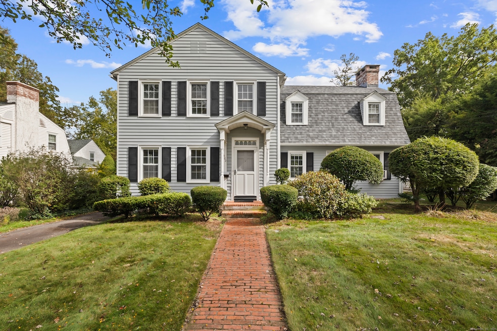
Welcome to 302 North Quaker Lane, located in the highly sought-after Morley Elementary School district of West Hartford! This home features a pristine exterior with a newer roof and vinyl replacement windows. Inside, you'll find a spacious formal living room, dining room, bright sunroom, a large kitchen, and two convenient half baths. Upstairs offers three generously sized bedrooms, including a spacious ensuite with a full bath. A newer gas heating system, hardwood floors under carpeting, and ample storage add to the appeal. Outside, enjoy a large, level backyard and a detached 2-car garage. Come make this charming and versatile home your dream house!
Last Agent to Sell the Property
Berkshire Hathaway NE Prop. Brokerage Phone: (860) 521-8100 License #RES.0398348 Listed on: 10/09/2025
Co-Listed By
Berkshire Hathaway NE Prop. Brokerage Phone: (860) 521-8100 License #RES.0796015
| Date | Type | Sale Price | Title Company |
|---|---|---|---|
| Executors Deed | $625,000 | -- | |
| Warranty Deed | $87,000 | -- | |
| Warranty Deed | $221,000 | -- |
| Date | Status | Loan Amount | Loan Type |
|---|---|---|---|
| Previous Owner | $131,000 | No Value Available | |
| Previous Owner | $86,400 | Purchase Money Mortgage | |
| Previous Owner | $95,000 | No Value Available | |
| Previous Owner | $100,000 | No Value Available |
| Date | Event | Price | List to Sale | Price per Sq Ft |
|---|---|---|---|---|
| 10/31/2025 10/31/25 | Sold | $625,000 | +4.2% | $230 / Sq Ft |
| 10/13/2025 10/13/25 | Pending | -- | -- | -- |
| 10/10/2025 10/10/25 | For Sale | $599,900 | -- | $220 / Sq Ft |
| Year | Tax Paid | Tax Assessment Tax Assessment Total Assessment is a certain percentage of the fair market value that is determined by local assessors to be the total taxable value of land and additions on the property. | Land | Improvement |
|---|---|---|---|---|
| 2025 | $12,019 | $268,390 | $125,100 | $143,290 |
| 2024 | $11,366 | $268,390 | $125,100 | $143,290 |
| 2023 | $10,983 | $268,390 | $125,100 | $143,290 |
| 2022 | $10,918 | $268,390 | $125,100 | $143,290 |
| 2021 | $9,648 | $227,430 | $102,620 | $124,810 |
| 2020 | $9,328 | $223,160 | $101,710 | $121,450 |
| 2019 | $9,328 | $223,160 | $101,710 | $121,450 |
| 2018 | $9,150 | $223,160 | $101,710 | $121,450 |
| 2017 | $9,158 | $223,160 | $101,710 | $121,450 |
| 2016 | $10,377 | $262,640 | $111,580 | $151,060 |
| 2015 | $10,140 | $264,670 | $111,580 | $153,090 |
| 2014 | $9,891 | $264,670 | $111,580 | $153,090 |
Seller's Agent in 2025
John Lepore
Berkshire Hathaway Home Services
(860) 798-7844
248 in this area
515 Total Sales
K
Seller Co-Listing Agent in 2025
Kevin Eagan
Berkshire Hathaway Home Services
(860) 416-3333
150 in this area
280 Total Sales
Buyer's Agent in 2025
Esther Roberts
William Raveis Real Estate
(860) 416-8555
12 in this area
61 Total Sales
Source: SmartMLS
MLS Number: 24132582
APN: WHAR-000006G-003838-000302
Disclaimer: Certain information contained herein is derived from information provided by parties other than Homes.com. All information provided is deemed reliable, but is not guaranteed to be accurate and should be independently verified.
![]() IDX information is provided exclusively for personal, non-commercial use, and may not be used for any purpose other than to identify prospective properties consumers may be interested in purchasing. Information is deemed reliable but not guaranteed.
IDX information is provided exclusively for personal, non-commercial use, and may not be used for any purpose other than to identify prospective properties consumers may be interested in purchasing. Information is deemed reliable but not guaranteed.