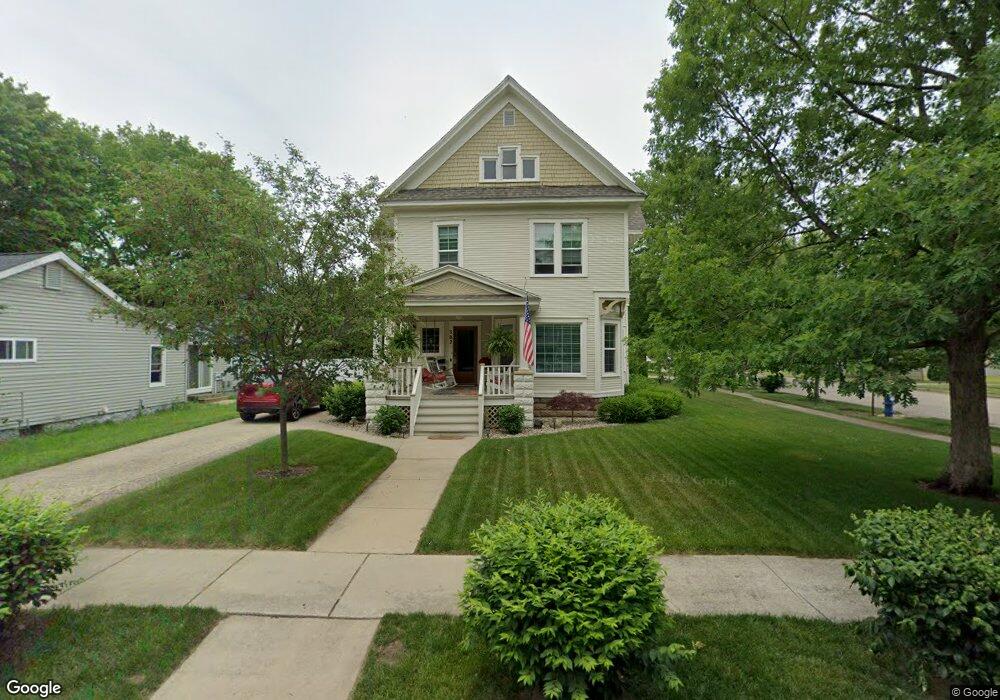
302 S Anderson St Plainwell, MI 49080
Estimated Value: $244,426 - $275,000
3
Beds
1
Bath
2,371
Sq Ft
$111/Sq Ft
Est. Value
About This Home
This home is located at 302 S Anderson St, Plainwell, MI 49080 and is currently estimated at $262,857, approximately $110 per square foot. 302 S Anderson St is a home located in Allegan County with nearby schools including Plainwell High School and Otsego Christian Academy.
Ownership History
Date
Name
Owned For
Owner Type
Purchase Details
Closed on
Jun 30, 2021
Sold by
Tiller Joyce E
Bought by
Mcbain Michael W
Current Estimated Value
Purchase Details
Closed on
Jan 26, 2012
Sold by
Tiller Joyce E
Bought by
Mcbain Michael W and Tiller Gerald L
Purchase Details
Closed on
Oct 4, 2004
Sold by
Mcbain Tiller Joyce E and Mcbain Richard A
Bought by
The Joyce E Tiller Trust
Create a Home Valuation Report for This Property
The Home Valuation Report is an in-depth analysis detailing your home's value as well as a comparison with similar homes in the area
Home Values in the Area
Average Home Value in this Area
Purchase History
| Date | Buyer | Sale Price | Title Company |
|---|---|---|---|
| Mcbain Michael W | -- | None Available | |
| Mcbain Michael W | -- | None Available | |
| Tiller Joyce E | -- | None Available | |
| The Joyce E Tiller Trust | -- | -- |
Source: Public Records
Tax History Compared to Growth
Tax History
| Year | Tax Paid | Tax Assessment Tax Assessment Total Assessment is a certain percentage of the fair market value that is determined by local assessors to be the total taxable value of land and additions on the property. | Land | Improvement |
|---|---|---|---|---|
| 2025 | $2,878 | $113,600 | $23,300 | $90,300 |
| 2024 | $2,604 | $104,200 | $20,800 | $83,400 |
| 2023 | $2,634 | $88,200 | $18,500 | $69,700 |
| 2022 | $2,604 | $78,100 | $15,600 | $62,500 |
| 2021 | $2,501 | $71,900 | $14,100 | $57,800 |
| 2020 | $2,469 | $66,900 | $12,100 | $54,800 |
| 2019 | $2,240 | $60,300 | $10,800 | $49,500 |
| 2018 | $0 | $58,600 | $12,100 | $46,500 |
| 2017 | $0 | $58,200 | $10,900 | $47,300 |
| 2016 | $0 | $54,200 | $9,300 | $44,900 |
| 2015 | -- | $54,200 | $9,300 | $44,900 |
| 2014 | -- | $48,200 | $9,100 | $39,100 |
| 2013 | -- | $47,000 | $9,100 | $37,900 |
Source: Public Records
Map
Nearby Homes
- 317 E Chart St
- 204 N Sherwood Ave
- 426 W Bridge St
- 721 E Bridge St
- 140 W 1st Ave
- 551 W Bridge St
- 1056 Elmwood St
- 623 Glenview Cir
- 771 N Main St
- V/L 11th St
- 455 N 10th St
- 355 12th St
- 390 12th St
- 830 Miller Rd Unit 9.86 Acres
- 830 Miller Rd Unit 26.94 Acres
- 830 Miller Rd Unit 15 Acres
- 518 Foxmoor Dr Unit 39
- 965 Miller Rd
- 1036 Sir Knight Rd
- 742 Miller Rd
- 308 S Anderson St
- 204 E Grant St
- 220 S Anderson St
- 104 E Grant St
- 309 S Anderson St
- 109 E Grant St
- 208 E Grant St
- 117 E Hill St
- 210 S Anderson St
- 221 S Anderson St
- 113 E Hill St
- 309 S Main St
- 303 S Main St
- 303 S Main St Unit B
- 303 S Main St Unit A
- 321 S Anderson St
- 209 E Grant St
- 221 S Main St
- 315 S Main St
- 214 E Grant St