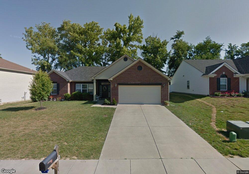
3020 Mooring Rd Evansville, IN 47725
Estimated Value: $285,000 - $312,000
3
Beds
2
Baths
1,875
Sq Ft
$162/Sq Ft
Est. Value
About This Home
This home is located at 3020 Mooring Rd, Evansville, IN 47725 and is currently estimated at $302,847, approximately $161 per square foot. 3020 Mooring Rd is a home located in Vanderburgh County with nearby schools including McCutchanville Elementary School, North Junior High School, and North High School.
Ownership History
Date
Name
Owned For
Owner Type
Purchase Details
Closed on
May 8, 2017
Sold by
Caldwell Rodger
Bought by
Stevison Floyd
Current Estimated Value
Purchase Details
Closed on
Jul 25, 2007
Sold by
Jagoe Homes Inc
Bought by
Stewart Michael A and Stewart Jenevelyn L
Home Financials for this Owner
Home Financials are based on the most recent Mortgage that was taken out on this home.
Original Mortgage
$171,073
Interest Rate
6.69%
Mortgage Type
FHA
Create a Home Valuation Report for This Property
The Home Valuation Report is an in-depth analysis detailing your home's value as well as a comparison with similar homes in the area
Home Values in the Area
Average Home Value in this Area
Purchase History
| Date | Buyer | Sale Price | Title Company |
|---|---|---|---|
| Stevison Floyd | -- | None Available | |
| Stewart Michael A | -- | Foreman Watson Land Title Ll |
Source: Public Records
Mortgage History
| Date | Status | Borrower | Loan Amount |
|---|---|---|---|
| Previous Owner | Stewart Michael A | $171,073 |
Source: Public Records
Tax History Compared to Growth
Tax History
| Year | Tax Paid | Tax Assessment Tax Assessment Total Assessment is a certain percentage of the fair market value that is determined by local assessors to be the total taxable value of land and additions on the property. | Land | Improvement |
|---|---|---|---|---|
| 2024 | $3,216 | $299,100 | $24,500 | $274,600 |
| 2023 | $3,071 | $290,700 | $24,500 | $266,200 |
| 2022 | $2,989 | $266,300 | $24,500 | $241,800 |
| 2021 | $2,267 | $206,500 | $24,500 | $182,000 |
| 2020 | $2,207 | $208,500 | $24,500 | $184,000 |
| 2019 | $1,922 | $188,200 | $24,500 | $163,700 |
| 2018 | $1,738 | $179,100 | $24,500 | $154,600 |
| 2017 | $1,702 | $177,200 | $24,500 | $152,700 |
| 2016 | $1,541 | $168,400 | $24,500 | $143,900 |
| 2014 | $1,442 | $161,600 | $24,500 | $137,100 |
| 2013 | -- | $160,000 | $24,500 | $135,500 |
Source: Public Records
Map
Nearby Homes
- 3044 Birdie Cir
- 10235 Admiral Dr
- 2939 Lucerne Ave
- 10835 Sable Ridge Dr
- 3000 Locker Ct
- 2935 Tipperary Dr
- 2934 Tipperary Dr
- 11134 Ensle Dr
- 9728 Clippinger Rd
- 11135 Ensle Dr
- 3001 Atcheson Dr
- 2947 Atcheson Dr
- 2935 Atcheson Dr
- 9919 Massey Dr
- 9629 Cayes Dr
- 9919 Blyth Dr
- 2748 Kincheloe Ct
- Little Rock Craftsman Plan at McCutchan Trace
- Revolution Farmhouse 3-Car Plan at McCutchan Trace
- Revolution Craftsman 3-Car Plan at McCutchan Trace
- 3032 Mooring Rd
- 3010 Mooring Rd
- 3040 Mooring Rd
- 2948 Mooring Rd
- 3035 Birdie Cir
- 10515 Chip Dr
- 3021 Mooring Rd
- 3011 Mooring Rd
- 3033 Mooring Rd
- 3045 Birdie Cir
- 2940 Mooring Rd
- 3100 Mooring Rd
- 2929 Brink Dr
- 2949 Mooring Rd
- 3041 Mooring Rd
- 10525 Chip Dr
- 2930 Mooring Rd
- 2941 Mooring Rd
- 3114 Mooring Rd
- 3034 Birdie Cir