
Seller's Agent in 2025
Rob Lotufo
Fathom Realty MO LLC
(423) 667-1246
130 Total Sales
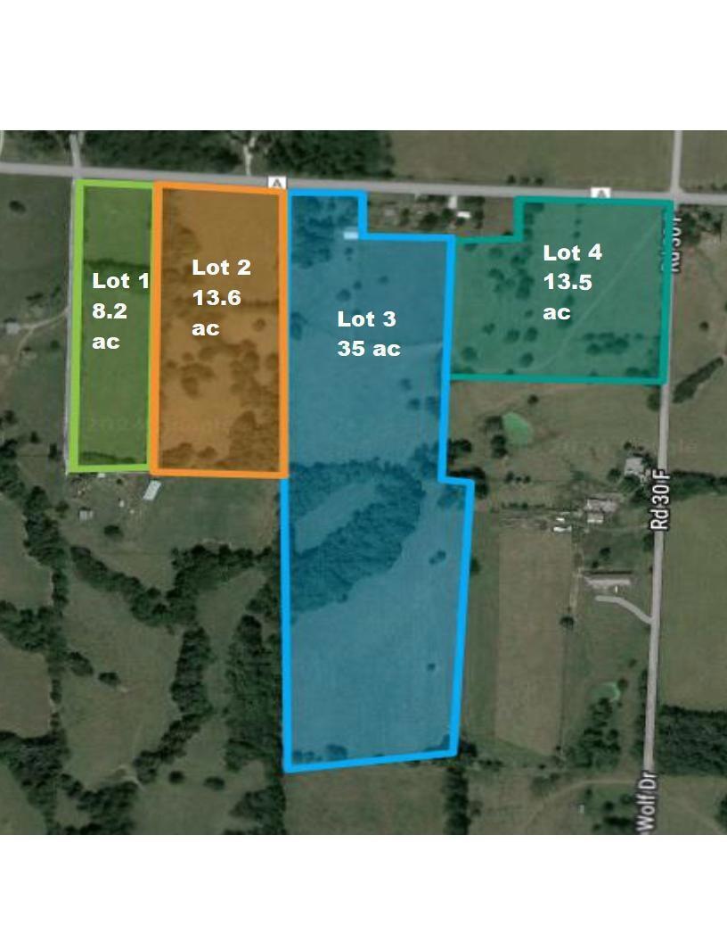
Great little property for a mini farm, homesite or whatever you chose. Fencing is currently suitable for cattle. Good pasture grass, just bring your animals, your toys, and call this place home! No restrictions, convenient to Wheaton, just 25 miles to AR state line (Pea Ridge).
Last Agent to Sell the Property
Fathom Realty MO LLC License #2016039608 Listed on: 10/07/2024
| Date | Type | Sale Price | Title Company |
|---|---|---|---|
| Warranty Deed | -- | None Listed On Document | |
| Warranty Deed | -- | None Listed On Document | |
| Personal Reps Deed | -- | None Listed On Document | |
| Personal Reps Deed | -- | None Listed On Document | |
| Personal Reps Deed | $333,240 | Barry County Title |
| Date | Status | Loan Amount | Loan Type |
|---|---|---|---|
| Open | $103,200 | Credit Line Revolving | |
| Closed | $103,200 | Credit Line Revolving |
| Date | Event | Price | List to Sale | Price per Sq Ft |
|---|---|---|---|---|
| 06/20/2025 06/20/25 | Sold | -- | -- | -- |
| 06/17/2025 06/17/25 | Price Changed | $475,000 | +365.7% | -- |
| 06/16/2025 06/16/25 | Pending | -- | -- | -- |
| 04/03/2025 04/03/25 | Price Changed | $102,000 | +10.3% | -- |
| 10/07/2024 10/07/24 | For Sale | $92,500 | -- | -- |
| Year | Tax Paid | Tax Assessment Tax Assessment Total Assessment is a certain percentage of the fair market value that is determined by local assessors to be the total taxable value of land and additions on the property. | Land | Improvement |
|---|---|---|---|---|
| 2024 | $486 | $9,850 | -- | -- |
| 2023 | $486 | $9,850 | $4,084 | $5,766 |
| 2022 | $486 | $9,350 | -- | -- |
| 2021 | $440 | $8,940 | $0 | $0 |
| 2020 | $405 | $8,480 | $0 | $0 |
| 2019 | $404 | $8,480 | $0 | $0 |
| 2018 | $0 | $8,670 | $0 | $0 |
| 2017 | $415 | $8,670 | $0 | $0 |
| 2016 | $415 | $8,670 | $0 | $0 |
| 2015 | -- | $8,670 | $0 | $0 |
| 2014 | -- | $8,670 | $0 | $0 |
Seller's Agent in 2025
Rob Lotufo
Fathom Realty MO LLC
(423) 667-1246
130 Total Sales
Source: Southern Missouri Regional MLS
MLS Number: 60279486
APN: 24-9.0-31-000-000-004.000
Disclaimer: Certain information contained herein is derived from information provided by parties other than Homes.com. All information provided is deemed reliable, but is not guaranteed to be accurate and should be independently verified.
![]() Based on information submitted to the MLS GRID. All data is obtained from various sources and may not have been verified by broker or MLS GRID. Supplied Open House Information is subject to change without notice. All information should be independently reviewed and verified for accuracy. Properties may or may not be listed by the office/agent presenting the information. Some IDX listings have been excluded from this website. The data relating to real estate for sale on this web page comes in part from the Internet Data Exchange (IDX) of the Southern Missouri Regional MLS, LLC, Inc. Real estate listings held by Brokerage firms other than Homes.com, LLC are marked with the IDX logo and detailed information about them includes the name of the listing Brokers. The information being provided is for consumers’ personal, noncommercial use and may not be used for any purpose other than to identify prospective properties consumers may be interested in purchasing. The information being provided is not guaranteed, and all information should be verified by the consumer. Any representation that a web site contains all listings shall only mean that the website contains all listings available to the public through the IDX data feed. There may be other properties offered through a REALTOR® that have not been displayed on this site. © 2026 Southern Missouri Regional MLS, LLC. All rights reserved.
Based on information submitted to the MLS GRID. All data is obtained from various sources and may not have been verified by broker or MLS GRID. Supplied Open House Information is subject to change without notice. All information should be independently reviewed and verified for accuracy. Properties may or may not be listed by the office/agent presenting the information. Some IDX listings have been excluded from this website. The data relating to real estate for sale on this web page comes in part from the Internet Data Exchange (IDX) of the Southern Missouri Regional MLS, LLC, Inc. Real estate listings held by Brokerage firms other than Homes.com, LLC are marked with the IDX logo and detailed information about them includes the name of the listing Brokers. The information being provided is for consumers’ personal, noncommercial use and may not be used for any purpose other than to identify prospective properties consumers may be interested in purchasing. The information being provided is not guaranteed, and all information should be verified by the consumer. Any representation that a web site contains all listings shall only mean that the website contains all listings available to the public through the IDX data feed. There may be other properties offered through a REALTOR® that have not been displayed on this site. © 2026 Southern Missouri Regional MLS, LLC. All rights reserved.
SOMO MLS respects the intellectual property rights of others and expects you to do the same. Per the DMCA, SOMO MLS will respond expeditiously to claims of copyright infringement on the Site if submitted to SOMO MLS' s Copyright Agent as described below. Upon receipt of a notice alleging copyright infringement, SOMO MLS will take whatever action it deems appropriate within its sole discretion, including removal of the allegedly infringing materials. If you believe that your intellectual property rights have been violated by SOMO MLS or by a third party who has uploaded materials to the Site, please provide the following information to SOMO MLS' s designated Copyright Agent listed below:
a. A description of the copyrighted work or other intellectual property that you claim has been infringed;
b. A description of where the material that you claim is infringing is located on the Site;
c. An address, telephone number, and e-mail address where SOMO MLS can contact you and, if different, an e-mail address where the alleged infringing party, if not SOMO MLS, can contact you;
d. A statement that you have a good-faith belief that the use is not authorized by the copyright owner or other intellectual property rights owner, by its agent, or by law;
e. A statement by you under penalty of perjury that the information in your notice is accurate and that you are the copyright or intellectual property owner or are authorized to act on the owner's behalf;
f. Your electronic or physical signature. SOMO MLS may request additional information before removing any allegedly infringing material.
In the event SOMO MLS removes the allegedly infringing materials, SOMO MLS will immediately notify the person responsible for posting such materials that SOMO MLS removed or disabled access to the materials. SOMO MLS may also provide the responsible person with your e-mail address so that the person may respond to your allegations. SOMO MLS reserves the right to terminate, limit or suspend any user's access to the Site in the event of repeated infringing activity. If you believe that a user of this Site is a repeat infringer, please follow the above instructions to contact SOMO MLS's Copyright Agent. Please include sufficient information to assist SOMO MLS in determining that the user repeatedly engaged in infringing activity. SOMO MLS registered a designated agent with the Copyright Office pursuant to 17 U.S.C. 512(c). SOMO MLS's designated Copyright Agent is: Jeff Kester 1310 Primrose, Springfield, MO 65804, Phone: 417-883-1226, Email: jeff@gsbor.com
Based on information submitted to the MLS GRID
Ask me questions while you tour the home.