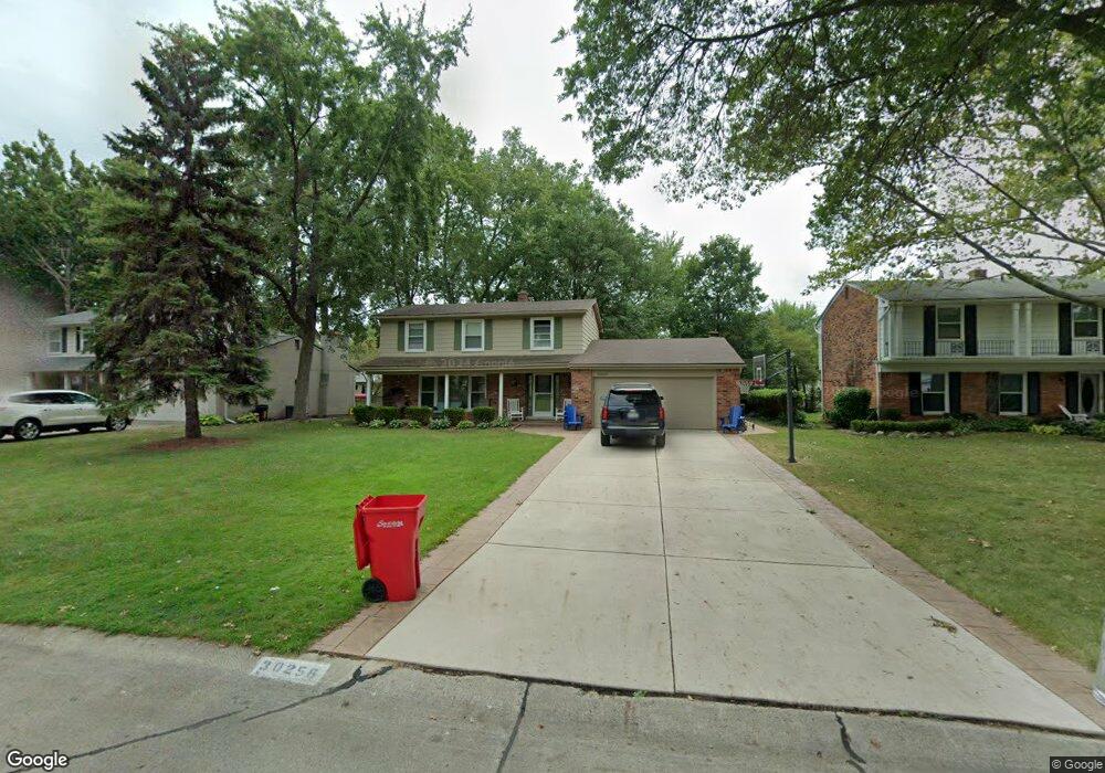
30256 Spring River Dr Southfield, MI 48076
Estimated Value: $368,000 - $421,000
--
Bed
3
Baths
2,068
Sq Ft
$186/Sq Ft
Est. Value
About This Home
This home is located at 30256 Spring River Dr, Southfield, MI 48076 and is currently estimated at $384,770, approximately $186 per square foot. 30256 Spring River Dr is a home located in Oakland County with nearby schools including Wylie E. Groves High School, Greenfield Elementary School, and Berkshire Middle School.
Ownership History
Date
Name
Owned For
Owner Type
Purchase Details
Closed on
May 31, 2007
Sold by
Woodard Byron J and Woodard Laurie M
Bought by
Moore Douglas B and Moore Kristin E
Current Estimated Value
Home Financials for this Owner
Home Financials are based on the most recent Mortgage that was taken out on this home.
Original Mortgage
$232,500
Outstanding Balance
$142,343
Interest Rate
6.2%
Mortgage Type
Purchase Money Mortgage
Estimated Equity
$242,427
Purchase Details
Closed on
Mar 1, 2001
Sold by
Gorell Jay M
Bought by
Woodard Byron J
Home Financials for this Owner
Home Financials are based on the most recent Mortgage that was taken out on this home.
Original Mortgage
$217,550
Interest Rate
7.02%
Mortgage Type
Purchase Money Mortgage
Purchase Details
Closed on
May 26, 1998
Sold by
Gorell Jay M
Bought by
Gorell Jay M
Create a Home Valuation Report for This Property
The Home Valuation Report is an in-depth analysis detailing your home's value as well as a comparison with similar homes in the area
Home Values in the Area
Average Home Value in this Area
Purchase History
| Date | Buyer | Sale Price | Title Company |
|---|---|---|---|
| Moore Douglas B | $245,000 | Homeland Title & Escrow Agen | |
| Woodard Byron J | $229,000 | -- | |
| Gorell Jay M | -- | -- |
Source: Public Records
Mortgage History
| Date | Status | Borrower | Loan Amount |
|---|---|---|---|
| Open | Moore Douglas B | $232,500 | |
| Previous Owner | Woodard Byron J | $217,550 |
Source: Public Records
Tax History Compared to Growth
Tax History
| Year | Tax Paid | Tax Assessment Tax Assessment Total Assessment is a certain percentage of the fair market value that is determined by local assessors to be the total taxable value of land and additions on the property. | Land | Improvement |
|---|---|---|---|---|
| 2022 | $3,741 | $148,680 | $22,690 | $125,990 |
| 2021 | $3,684 | $130,410 | $22,690 | $107,720 |
| 2020 | $3,316 | $124,290 | $18,810 | $105,480 |
| 2018 | $3,532 | $97,900 | $18,810 | $79,090 |
| 2015 | -- | $73,150 | $0 | $0 |
| 2014 | -- | $58,600 | $0 | $0 |
| 2011 | -- | $61,010 | $0 | $0 |
Source: Public Records
Map
Nearby Homes
- 30301 Spring River Dr
- 19245 Eldridge Ln
- 30560 Northgate Dr
- 30130 Woodgate Dr
- 31018 Pickwick Ln
- 29807 Spring Hill Dr
- 29743 Chelmsford Rd
- 18240 Webster Ave
- 29848 Rambling Rd
- 29662 Westbrook Pkwy
- 19710 W 13 Mile Rd Unit 111
- 19710 W 13 Mile Rd Unit 105
- 19710 W 13 Mile Rd Unit 201
- 19710 W 13 Mile Rd Unit 108
- 29484 Spring Hill Dr
- 31698 Southview St
- 30268 Southfield Rd Unit 229
- 30200 Southfield Rd Unit 204
- 19938 Waltham Rd
- 31462 Waltham Rd
- 30250 Spring River Dr
- 30262 Spring River Dr
- 30155 Pleasant Trail
- 30238 Spring River Dr
- 30165 Pleasant Trail
- 30145 Pleasant Trail
- 30266 Spring River Dr
- 30266 Spring
- 30247 Spring-River Dr
- 30247 Spring River Dr
- 30253 Spring River Dr
- 30232 Spring River Dr
- 30135 Pleasant Trail
- 30175 Pleasant Trail
- 30259 Spring River Dr
- 30243 Spring River Dr
- 30270 Spring River Dr
- 30241 Spring River Dr
- 30265 Spring River Dr
- 30265 Spring-River Dr