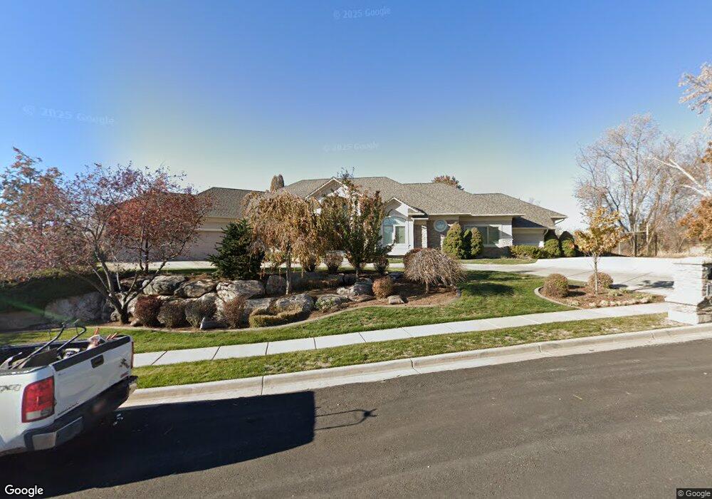
303 Boynton Rd Kaysville, UT 84037
Estimated Value: $1,252,000 - $1,844,274
3
Beds
3
Baths
7,100
Sq Ft
$215/Sq Ft
Est. Value
About This Home
This home is located at 303 Boynton Rd, Kaysville, UT 84037 and is currently estimated at $1,523,069, approximately $214 per square foot. 303 Boynton Rd is a home located in Davis County with nearby schools including Creekside Elementary School, Fairfield Junior High School, and Davis High School.
Ownership History
Date
Name
Owned For
Owner Type
Purchase Details
Closed on
Jun 14, 2022
Sold by
Layton and Michie
Bought by
Layton Lowell James
Current Estimated Value
Purchase Details
Closed on
Apr 16, 2020
Sold by
Taylor Reva W and Taylor Craig L
Bought by
Layton Lowell and Layton Michie
Home Financials for this Owner
Home Financials are based on the most recent Mortgage that was taken out on this home.
Original Mortgage
$670,000
Interest Rate
3.2%
Mortgage Type
New Conventional
Purchase Details
Closed on
Aug 29, 2007
Sold by
Taylor Reva W and Taylor Craig L
Bought by
Taylor Reva W and Taylor Craig L
Home Financials for this Owner
Home Financials are based on the most recent Mortgage that was taken out on this home.
Original Mortgage
$150,000
Interest Rate
6.74%
Mortgage Type
Credit Line Revolving
Purchase Details
Closed on
Jun 28, 2004
Sold by
Taylor Reva W and Taylor Craig L
Bought by
Taylor Reva W and Taylor Craig L
Home Financials for this Owner
Home Financials are based on the most recent Mortgage that was taken out on this home.
Original Mortgage
$175,000
Interest Rate
6.27%
Mortgage Type
Credit Line Revolving
Purchase Details
Closed on
Jul 30, 2003
Sold by
Taylor Craig L and Taylor Reva W
Bought by
Taylor Reva W and Taylor Craig L
Purchase Details
Closed on
May 14, 2003
Sold by
Owens Don L and Owens Dixie T
Bought by
Taylor Craig L and Taylor Reva W
Home Financials for this Owner
Home Financials are based on the most recent Mortgage that was taken out on this home.
Original Mortgage
$399,900
Interest Rate
4.37%
Mortgage Type
Purchase Money Mortgage
Purchase Details
Closed on
Oct 6, 1999
Sold by
Owens Don L and Owens Dixie T
Bought by
Owens Don L and Owens Dixie T
Purchase Details
Closed on
Feb 26, 1999
Sold by
Owens Dixie T and Owens Don L
Bought by
Owens Don L and Owens Dixie T
Home Financials for this Owner
Home Financials are based on the most recent Mortgage that was taken out on this home.
Original Mortgage
$350,000
Interest Rate
6.76%
Create a Home Valuation Report for This Property
The Home Valuation Report is an in-depth analysis detailing your home's value as well as a comparison with similar homes in the area
Home Values in the Area
Average Home Value in this Area
Purchase History
| Date | Buyer | Sale Price | Title Company |
|---|---|---|---|
| Layton Lowell James | -- | None Listed On Document | |
| Layton Lowell | -- | North American Title | |
| Taylor Reva W | -- | Security Title | |
| Taylor Reva W | -- | Security Title | |
| Taylor Reva W | -- | Security Title Company | |
| Taylor Reva W | -- | Security Title Company | |
| Taylor Reva W | -- | -- | |
| Taylor Craig L | -- | First American Title Co | |
| Owens Don L | -- | -- | |
| Owens Don L | -- | Home Abstract & Title Co |
Source: Public Records
Mortgage History
| Date | Status | Borrower | Loan Amount |
|---|---|---|---|
| Previous Owner | Layton Lowell | $670,000 | |
| Previous Owner | Taylor Reva W | $150,000 | |
| Previous Owner | Taylor Reva W | $175,000 | |
| Previous Owner | Taylor Craig L | $399,900 | |
| Previous Owner | Owens Don L | $350,000 |
Source: Public Records
Tax History Compared to Growth
Tax History
| Year | Tax Paid | Tax Assessment Tax Assessment Total Assessment is a certain percentage of the fair market value that is determined by local assessors to be the total taxable value of land and additions on the property. | Land | Improvement |
|---|---|---|---|---|
| 2024 | $7,520 | $844,339 | $273,670 | $570,669 |
| 2023 | $6,917 | $1,373,000 | $509,608 | $863,392 |
| 2022 | $6,650 | $711,150 | $281,063 | $430,087 |
| 2021 | $0 | $1,035,000 | $360,074 | $674,926 |
| 2020 | $5,211 | $797,000 | $339,597 | $457,403 |
| 2019 | $5,236 | $776,000 | $299,748 | $476,252 |
| 2018 | $4,875 | $724,000 | $273,883 | $450,117 |
| 2016 | $4,846 | $378,955 | $99,135 | $279,820 |
| 2015 | $4,758 | $354,975 | $99,135 | $255,840 |
| 2014 | $5,150 | $392,194 | $99,135 | $293,059 |
| 2013 | -- | $387,527 | $89,518 | $298,009 |
Source: Public Records
Map
Nearby Homes
- 250 E 950 N
- 928 E Mutton Hollow Rd
- 425 E 500 N
- 285 E 500 N
- 298 S Bing Cherry Way
- 1578 E Maple Way
- 457 N 150 E
- 1913 E 75 S
- 400 N 100 E
- 1199 E Pheasant View Dr
- 890 E Brookshire Dr
- 593 N 150 W
- 222 S Derrah Dr
- 1093 N Bedford Dr
- 694 S Pheasant View Dr
- 272 Pin Oak Ln
- 952 N Kingswood Rd
- 1306 N Thornfield Rd
- 990 Manchester Rd
- 1168 Holmes Creek Ln
- 303 E Boynton Rd
- 297 Boynton Rd
- 272 E 950 N
- 278 E 950 N
- 278 E 950 N Unit 12
- 289 Boynton Rd
- 289 E Boynton Rd Unit 22
- 289 E Boynton Rd
- 254 E 950 N
- 275 E 950 N
- 283 Boynton Rd
- 1445 N Orchard Ridge Ln
- 1466 N Orchard Ridge Ln
- 1421 N Orchard Ridge Ln
- 1432 N Orchard Ridge Ln
- 1478 N Orchard Ridge Ln
- 259 E 950 N
- 387 Boynton Rd
- 892 N 240 E
- 271 Boynton Rd