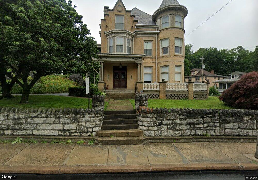
303 W King St Shippensburg, PA 17257
Estimated Value: $434,000 - $508,000
--
Bed
--
Bath
--
Sq Ft
0.77
Acres
About This Home
This home is located at 303 W King St, Shippensburg, PA 17257 and is currently estimated at $471,589. 303 W King St is a home located in Franklin County with nearby schools including Shippensburg Area Senior High School, Mt. Rock Parochial School, and Shippensburg Independent Baptist Christian Academy.
Ownership History
Date
Name
Owned For
Owner Type
Purchase Details
Closed on
Jun 10, 2025
Sold by
Gates Ortrun A
Bought by
Labe Benjamin D and Brune Lauren E
Current Estimated Value
Home Financials for this Owner
Home Financials are based on the most recent Mortgage that was taken out on this home.
Original Mortgage
$382,500
Outstanding Balance
$381,518
Interest Rate
6.81%
Mortgage Type
New Conventional
Estimated Equity
$90,071
Create a Home Valuation Report for This Property
The Home Valuation Report is an in-depth analysis detailing your home's value as well as a comparison with similar homes in the area
Home Values in the Area
Average Home Value in this Area
Purchase History
| Date | Buyer | Sale Price | Title Company |
|---|---|---|---|
| Labe Benjamin D | $510,000 | None Listed On Document |
Source: Public Records
Mortgage History
| Date | Status | Borrower | Loan Amount |
|---|---|---|---|
| Open | Labe Benjamin D | $382,500 |
Source: Public Records
Tax History Compared to Growth
Tax History
| Year | Tax Paid | Tax Assessment Tax Assessment Total Assessment is a certain percentage of the fair market value that is determined by local assessors to be the total taxable value of land and additions on the property. | Land | Improvement |
|---|---|---|---|---|
| 2025 | $6,823 | $37,810 | $5,380 | $32,430 |
| 2024 | $6,116 | $37,810 | $5,380 | $32,430 |
| 2023 | $6,008 | $37,810 | $5,380 | $32,430 |
| 2022 | $5,975 | $37,810 | $5,380 | $32,430 |
| 2021 | $5,835 | $37,810 | $5,380 | $32,430 |
| 2020 | $6,046 | $37,810 | $5,380 | $32,430 |
| 2019 | $5,972 | $37,810 | $5,380 | $32,430 |
| 2018 | $6,031 | $37,810 | $5,380 | $32,430 |
| 2017 | $5,712 | $35,980 | $5,380 | $30,600 |
| 2016 | $2,016 | $35,980 | $5,380 | $30,600 |
| 2015 | $1,946 | $35,980 | $5,380 | $30,600 |
| 2014 | $1,904 | $35,980 | $5,380 | $30,600 |
Source: Public Records
Map
Nearby Homes
- 302 W King St
- 307 W King St
- 32 Stewart Place
- 14 W Burd St
- 120 S Earl St
- 103 N Earl St
- 9 E Burd St
- 184 Park Heights Ave
- 24 and 26 E Orange St
- 100 E King St
- 112 E Burd St
- 136 Park Place E
- 610 Westover Rd
- 10050 Mccreary Rd
- 611 Prospect Ave
- 118 Baker and Russell Dr
- 700 Remington Dr
- 9807 Possum Hollow Rd
- 108 Baker and Russell Dr
- 201 Baker & Russell Dr
- 5 N Morris St
- 3 N Morris St
- 243 W King St
- 204212 King
- 300 W King St
- 304 W King St
- 239 W King St
- 237 W King St
- 13 N Morris St
- 240 W King St
- 238 W King St
- 14 N Morris St
- 520 W King St
- 0 Cressler Unit PAFL171506
- 308 W King St
- 232 W King St
- 225 W King St
- 17 N Morris St
- 306 W King St
- 306 W King St Unit C