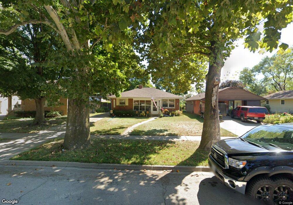
303 Westmoreland Ave Waukegan, IL 60085
West Waukegan NeighborhoodEstimated Value: $237,630 - $269,000
3
Beds
2
Baths
1,092
Sq Ft
$229/Sq Ft
Est. Value
About This Home
This home is located at 303 Westmoreland Ave, Waukegan, IL 60085 and is currently estimated at $250,158, approximately $229 per square foot. 303 Westmoreland Ave is a home located in Lake County with nearby schools including Whittier Elementary School, Robert E. Abbott Middle School, and Waukegan High School.
Ownership History
Date
Name
Owned For
Owner Type
Purchase Details
Closed on
Oct 16, 2009
Sold by
Board Of Trustees First United Methodist
Bought by
Moore Melinda M
Current Estimated Value
Home Financials for this Owner
Home Financials are based on the most recent Mortgage that was taken out on this home.
Original Mortgage
$127,645
Outstanding Balance
$82,581
Interest Rate
4.9%
Mortgage Type
FHA
Estimated Equity
$167,577
Create a Home Valuation Report for This Property
The Home Valuation Report is an in-depth analysis detailing your home's value as well as a comparison with similar homes in the area
Home Values in the Area
Average Home Value in this Area
Purchase History
| Date | Buyer | Sale Price | Title Company |
|---|---|---|---|
| Moore Melinda M | -- | Natc |
Source: Public Records
Mortgage History
| Date | Status | Borrower | Loan Amount |
|---|---|---|---|
| Open | Moore Melinda M | $127,645 |
Source: Public Records
Tax History Compared to Growth
Tax History
| Year | Tax Paid | Tax Assessment Tax Assessment Total Assessment is a certain percentage of the fair market value that is determined by local assessors to be the total taxable value of land and additions on the property. | Land | Improvement |
|---|---|---|---|---|
| 2024 | $4,266 | $59,471 | $10,197 | $49,274 |
| 2023 | $4,122 | $53,245 | $9,129 | $44,116 |
| 2022 | $4,122 | $48,165 | $7,767 | $40,398 |
| 2021 | $3,997 | $44,334 | $7,185 | $37,149 |
| 2020 | $4,002 | $41,303 | $6,694 | $34,609 |
| 2019 | $3,975 | $37,848 | $6,134 | $31,714 |
| 2018 | $3,526 | $33,654 | $7,892 | $25,762 |
| 2017 | $3,382 | $29,774 | $6,982 | $22,792 |
| 2016 | $3,071 | $25,872 | $6,067 | $19,805 |
| 2015 | $2,898 | $23,156 | $5,430 | $17,726 |
| 2014 | $2,880 | $22,558 | $6,069 | $16,489 |
| 2012 | $3,789 | $24,441 | $6,576 | $17,865 |
Source: Public Records
Map
Nearby Homes
- 1820 Jenkinson Ct
- 427 Tiffany Dr
- 1527 Brookside Ave
- 132 Dorchester Ct
- 615 Tiffany Dr
- 1213 Grand Ave
- 0 Brookside Ave
- 1416 Hamilton Ct
- 619 N Butrick St
- 1521 Catalpa Ave
- 306 Oak Crest St
- 216 S Martin Ave
- 24 Washington Terrace
- 1005 N Lewis Ave
- 1023 N Elmwood Ave
- 1109 Massena Ave
- 1038 Indiana Ave
- 102 Baldwin Ave
- 1000 Pine St
- 511 Chestnut St
- 225 Westmoreland Ave
- 307 Westmoreland Ave
- 221 Westmoreland Ave
- 311 Westmoreland Ave
- 226 N Lewis Ave
- 224 N Lewis Ave
- 306 N Lewis Ave
- 315 Westmoreland Ave
- 310 N Lewis Ave
- 215 Westmoreland Ave
- 314 N Lewis Ave
- 302 Westmoreland Ave
- 224 Westmoreland Ave
- 314 Westmoreland Ave
- 1931 Brookside Ave
- 220 Westmoreland Ave
- 318 N Lewis Ave
- 118 Westmoreland Ave
- 2001 Brookside Ave
- 2006 W Monroe St