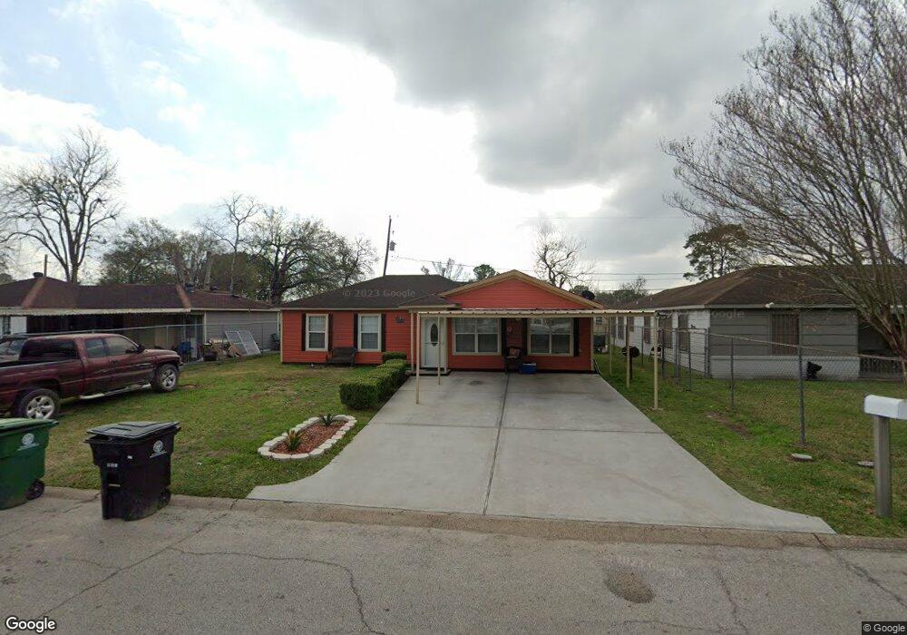
3032 Durwood St Houston, TX 77093
Eastex-Jensen NeighborhoodEstimated Value: $160,708 - $199,000
4
Beds
1
Bath
1,174
Sq Ft
$155/Sq Ft
Est. Value
About This Home
This home is located at 3032 Durwood St, Houston, TX 77093 and is currently estimated at $181,927, approximately $154 per square foot. 3032 Durwood St is a home located in Harris County with nearby schools including Scarborough Elementary School, Patrick Henry Middle School, and Sam Houston Math, Science & Technology Center.
Ownership History
Date
Name
Owned For
Owner Type
Purchase Details
Closed on
May 18, 2001
Sold by
Ramirez Ciro Sergio and Ramirez Arcelia
Bought by
Zapata Juan P
Current Estimated Value
Home Financials for this Owner
Home Financials are based on the most recent Mortgage that was taken out on this home.
Original Mortgage
$59,225
Outstanding Balance
$22,082
Interest Rate
7.01%
Mortgage Type
FHA
Estimated Equity
$159,845
Create a Home Valuation Report for This Property
The Home Valuation Report is an in-depth analysis detailing your home's value as well as a comparison with similar homes in the area
Home Values in the Area
Average Home Value in this Area
Purchase History
| Date | Buyer | Sale Price | Title Company |
|---|---|---|---|
| Zapata Juan P | -- | Texas American Title Company |
Source: Public Records
Mortgage History
| Date | Status | Borrower | Loan Amount |
|---|---|---|---|
| Open | Zapata Juan P | $59,225 |
Source: Public Records
Tax History Compared to Growth
Tax History
| Year | Tax Paid | Tax Assessment Tax Assessment Total Assessment is a certain percentage of the fair market value that is determined by local assessors to be the total taxable value of land and additions on the property. | Land | Improvement |
|---|---|---|---|---|
| 2025 | $1,129 | $150,436 | $54,600 | $95,836 |
| 2024 | $1,129 | $140,836 | $45,000 | $95,836 |
| 2023 | $1,129 | $139,334 | $45,000 | $94,334 |
| 2022 | $2,092 | $124,109 | $30,000 | $94,109 |
| 2021 | $2,013 | $100,301 | $19,500 | $80,801 |
| 2020 | $1,901 | $95,120 | $19,500 | $75,620 |
| 2019 | $1,806 | $89,469 | $16,500 | $72,969 |
| 2018 | $1,018 | $64,886 | $16,500 | $48,386 |
| 2017 | $1,641 | $64,886 | $16,500 | $48,386 |
| 2016 | $1,503 | $59,437 | $16,500 | $42,937 |
| 2015 | $1,049 | $59,437 | $16,500 | $42,937 |
| 2014 | $1,049 | $59,437 | $16,500 | $42,937 |
Source: Public Records
Map
Nearby Homes
- 1904 Little York Rd
- 1728 Little York Rd
- 4918 Langley Rd
- 2636 Lone Oak Rd
- 2629 Kowis St
- 3804 Cedar Hill Ln
- 2817 Cromwell St
- 3202 Parker Rd
- 3418 Hopper Rd
- 2315 Langley Rd
- 2332 Margaret St
- 2415 Goodloe St
- 3709 Gager St
- 3214 Brea Crest St
- 4410 Shelton Rd
- 2633 Hollis St
- 2318 Cresline St
- 2915 Brea Crest St
- 2311 Warwick Rd
- 2237 Cromwell St
- 3028 Durwood St
- 3036 Durwood St
- 3031 Rothermel Rd
- 3039 Rothermel Rd
- 3024 Durwood St
- 3040 Durwood St
- 3027 Rothermel Rd
- 3043 Rothermel Rd
- 3027 Durwood St
- 3031 Durwood St
- 3023 Durwood St
- 3020 Durwood St
- 3044 Durwood St
- 3035 Durwood St
- 3023 Rothermel Rd
- 3047 Rothermel Rd
- 3016 Durwood St
- 3048 Durwood St
- 3039 Durwood St
- 3015 Durwood St