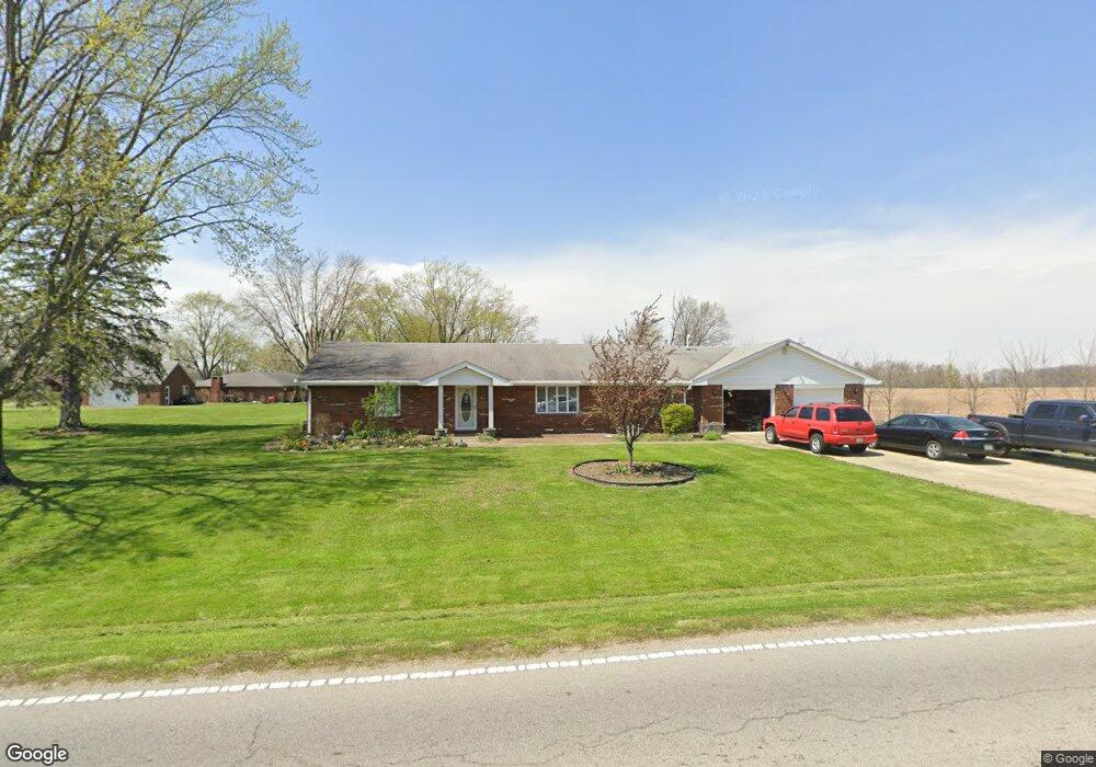
3039 N 100 W Anderson, IN 46011
Estimated Value: $238,000 - $276,000
3
Beds
3
Baths
1,873
Sq Ft
$141/Sq Ft
Est. Value
About This Home
This home is located at 3039 N 100 W, Anderson, IN 46011 and is currently estimated at $263,400, approximately $140 per square foot. 3039 N 100 W is a home located in Madison County with nearby schools including Frankton Elementary School, Frankton Junior/Senior High School, and Excel Center - Anderson.
Ownership History
Date
Name
Owned For
Owner Type
Purchase Details
Closed on
Nov 16, 2016
Sold by
Nicholas Todd
Bought by
Jones Todd and Jones Susan
Current Estimated Value
Purchase Details
Closed on
Nov 14, 2016
Sold by
Knotts Joy and Lawrence Leslie
Bought by
Peace Mison
Purchase Details
Closed on
Jan 28, 2016
Sold by
Knotts Joy
Bought by
Knotts Joy
Purchase Details
Closed on
Nov 20, 2013
Sold by
Knotts Joy and Lawrence Leslie
Bought by
Knotts Joy and Lawrence Leslie
Purchase Details
Closed on
Oct 7, 2011
Sold by
Kuklenski Mary Ann
Bought by
Knotts Joy
Purchase Details
Closed on
Jan 14, 2011
Sold by
Kuklenski Mary Ann and Kuklenski William Joseph
Bought by
Kuklenski Mary Ann
Create a Home Valuation Report for This Property
The Home Valuation Report is an in-depth analysis detailing your home's value as well as a comparison with similar homes in the area
Home Values in the Area
Average Home Value in this Area
Purchase History
| Date | Buyer | Sale Price | Title Company |
|---|---|---|---|
| Jones Todd | -- | Fidelity National Title | |
| Peace Mison | -- | -- | |
| Knotts Joy | -- | -- | |
| Knotts Joy | -- | -- | |
| Knotts Joy | -- | None Available | |
| Kuklenski Mary Ann | -- | -- |
Source: Public Records
Tax History Compared to Growth
Tax History
| Year | Tax Paid | Tax Assessment Tax Assessment Total Assessment is a certain percentage of the fair market value that is determined by local assessors to be the total taxable value of land and additions on the property. | Land | Improvement |
|---|---|---|---|---|
| 2024 | $973 | $143,000 | $22,100 | $120,900 |
| 2023 | $914 | $130,600 | $21,000 | $109,600 |
| 2022 | $1,378 | $145,400 | $20,000 | $125,400 |
| 2021 | $1,451 | $134,800 | $20,000 | $114,800 |
| 2020 | $1,435 | $128,000 | $19,000 | $109,000 |
| 2019 | $1,373 | $122,900 | $16,900 | $106,000 |
| 2018 | $1,287 | $113,200 | $16,900 | $96,300 |
| 2017 | $1,212 | $114,800 | $16,900 | $97,900 |
| 2016 | $1,209 | $137,000 | $16,900 | $120,100 |
| 2014 | $4,195 | $205,700 | $15,500 | $190,200 |
| 2013 | $4,195 | $197,900 | $15,500 | $182,400 |
Source: Public Records
Map
Nearby Homes
- 1053 W 300 N
- 601 Belzer Dr
- 2915 Harbur Blvd
- 2413 Silver St
- 391 W 375 N
- 143 E School St
- 2334 Poplar St
- 305 Mohawk St
- 2717 Apache Dr
- 1907 Lowell Ave
- 1820 Whittier Ave
- 2722 Dakota Dr
- 2976 N Scatterfield Rd
- 2132 Poplar St
- 2030 Broadway St
- 718 Hawthorne Ave
- 1905 E Balsam Ct
- 2003 Crystal St
- 724 Iroquois St
- 724 Iroquois Dr