Estimated Value: $119,000 - $148,000
2
Beds
1
Bath
1,280
Sq Ft
$108/Sq Ft
Est. Value
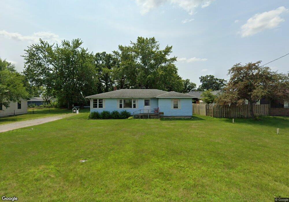
About This Home
This home is located at 304 Airway Dr, Knox, IN 46534 and is currently estimated at $138,607, approximately $108 per square foot. 304 Airway Dr is a home located in Starke County with nearby schools including Knox Community Elementary School, Knox Community Middle School, and Knox Community High School.
Ownership History
Date
Name
Owned For
Owner Type
Purchase Details
Closed on
Nov 6, 2023
Sold by
Martin Robert A and Martin Annette K
Bought by
Ram Rentals Llc
Current Estimated Value
Purchase Details
Closed on
Sep 9, 2020
Sold by
Glass Darrell D and Glass Meredith L
Bought by
Martin Robert A and Martin Annette K
Home Financials for this Owner
Home Financials are based on the most recent Mortgage that was taken out on this home.
Original Mortgage
$61,600
Interest Rate
2.9%
Mortgage Type
New Conventional
Create a Home Valuation Report for This Property
The Home Valuation Report is an in-depth analysis detailing your home's value as well as a comparison with similar homes in the area
Home Values in the Area
Average Home Value in this Area
Purchase History
| Date | Buyer | Sale Price | Title Company |
|---|---|---|---|
| Ram Rentals Llc | -- | None Listed On Document | |
| Martin Robert A | -- | Meridian Title Corp |
Source: Public Records
Mortgage History
| Date | Status | Borrower | Loan Amount |
|---|---|---|---|
| Previous Owner | Martin Robert A | $61,600 |
Source: Public Records
Tax History Compared to Growth
Tax History
| Year | Tax Paid | Tax Assessment Tax Assessment Total Assessment is a certain percentage of the fair market value that is determined by local assessors to be the total taxable value of land and additions on the property. | Land | Improvement |
|---|---|---|---|---|
| 2024 | $1,942 | $95,500 | $21,300 | $74,200 |
| 2023 | $1,838 | $90,300 | $19,400 | $70,900 |
| 2022 | $1,599 | $79,900 | $19,400 | $60,500 |
| 2021 | $1,467 | $73,300 | $19,400 | $53,900 |
| 2020 | $1,338 | $65,500 | $19,400 | $46,100 |
| 2019 | $1,261 | $62,000 | $19,400 | $42,600 |
| 2018 | $1,226 | $60,000 | $19,400 | $40,600 |
| 2017 | $1,214 | $59,400 | $19,400 | $40,000 |
| 2016 | $1,197 | $58,300 | $19,400 | $38,900 |
| 2014 | $1,186 | $59,000 | $19,400 | $39,600 |
| 2013 | $1,162 | $57,800 | $19,400 | $38,400 |
Source: Public Records
Map
Nearby Homes
- 313 Carlson Dr
- Tbd Pine St
- 0 Pine St & Cannon Dr-Ne Corner
- 703 S Main St
- 0 Carlson Dr
- 625 S East St
- 601 S Heaton St
- 1675 U S 35
- 701 S Shield St
- 605 S Main St
- TBD E 150 St N
- 705 E Saint Louis St
- 0000 S 350 E
- 400 S East St
- 4152 S State Road 35
- 400 S Main St
- 14.89 Acres W Culver Rd
- 1505 S Roosevelt Rd
- 308 E John St
- 600 S Roosevelt Rd