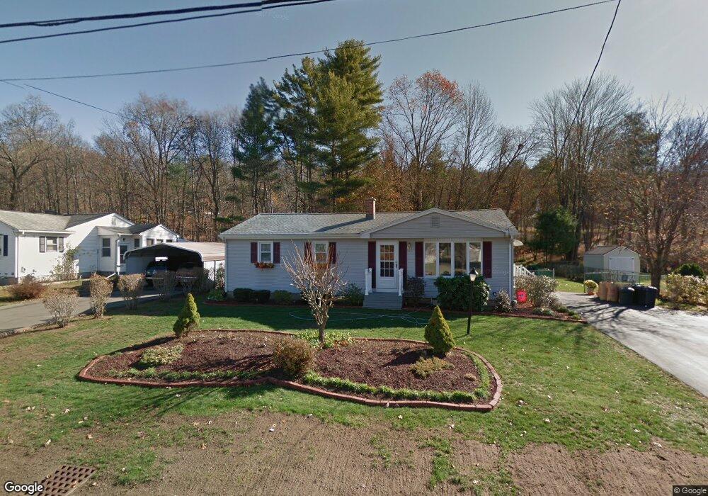
304 Apremont Hwy Holyoke, MA 01040
Estimated Value: $331,000 - $383,000
3
Beds
1
Bath
1,837
Sq Ft
$192/Sq Ft
Est. Value
About This Home
This home is located at 304 Apremont Hwy, Holyoke, MA 01040 and is currently estimated at $352,640, approximately $191 per square foot. 304 Apremont Hwy is a home located in Hampden County with nearby schools including Lt. Elmer J. McMahon Elementary School, Holyoke High School, and Blessed Sacrament School.
Ownership History
Date
Name
Owned For
Owner Type
Purchase Details
Closed on
Mar 18, 2024
Sold by
Redding Dorothy T
Bought by
Collins Deborah
Current Estimated Value
Purchase Details
Closed on
Mar 22, 1971
Bought by
Redding Walter D and Redding Dorothy T
Create a Home Valuation Report for This Property
The Home Valuation Report is an in-depth analysis detailing your home's value as well as a comparison with similar homes in the area
Home Values in the Area
Average Home Value in this Area
Purchase History
| Date | Buyer | Sale Price | Title Company |
|---|---|---|---|
| Collins Deborah | -- | None Available | |
| Redding Walter D | -- | -- |
Source: Public Records
Mortgage History
| Date | Status | Borrower | Loan Amount |
|---|---|---|---|
| Previous Owner | Redding Walter D | $42,000 | |
| Previous Owner | Redding Walter D | $10,000 | |
| Previous Owner | Redding Walter D | $6,500 |
Source: Public Records
Tax History Compared to Growth
Tax History
| Year | Tax Paid | Tax Assessment Tax Assessment Total Assessment is a certain percentage of the fair market value that is determined by local assessors to be the total taxable value of land and additions on the property. | Land | Improvement |
|---|---|---|---|---|
| 2025 | $4,667 | $267,300 | $62,700 | $204,600 |
| 2024 | $4,474 | $236,100 | $59,800 | $176,300 |
| 2023 | $4,283 | $228,300 | $59,800 | $168,500 |
| 2022 | $4,120 | $213,900 | $59,800 | $154,100 |
| 2021 | $3,943 | $204,600 | $57,200 | $147,400 |
| 2020 | $3,743 | $196,200 | $57,200 | $139,000 |
| 2019 | $3,640 | $188,700 | $57,200 | $131,500 |
| 2018 | $3,478 | $181,800 | $57,200 | $124,600 |
| 2017 | $3,485 | $181,800 | $57,200 | $124,600 |
| 2016 | $3,451 | $180,500 | $59,000 | $121,500 |
| 2015 | $3,437 | $180,500 | $59,000 | $121,500 |
Source: Public Records
Map
Nearby Homes
- 351 Apremont Hsy
- 397 Apremont Hwy
- 16 Davis St
- 94 Pequot Rd (Rear)
- 150 Middle Rd
- 64 Old Stage Rd
- 21 Old County Rd
- 128 Middle Rd
- Lot A Homestead Ave
- 695 Homestead Ave
- 178 County Rd
- 0 Char Dr
- 794 Homestead Ave
- Lot 57 White Loaf Rd
- 36 County Rd
- lot b Homestead Ave
- 7 Vermont St
- 286 Westfield Rd
- 86 Lynch Dr
- 36 Susan Dr
- 308 Apremont Hwy
- 302 Apremont Hwy
- 298 Apremont Hwy
- 303 Apremont Hwy
- 307 Apremont Hwy
- 314 Apremont Hwy
- 313 Apremont Hwy
- 294 Apremont Hwy
- 297 Apremont Hwy
- 316 Apremont Hwy
- 30 Dupuis Rd
- 319 Apremont Hwy
- 290 Apremont Hwy
- 320 Apremont Hwy
- 8 Coronet Rd
- 52 Dupuis Rd
- 11 Dupuis Rd
- 324 Apremont Hwy
- 325 Apremont Hwy
- 43 Dupuis Rd