Estimated Value: $108,000 - $123,000
--
Bed
2
Baths
1,134
Sq Ft
$101/Sq Ft
Est. Value
About This Home
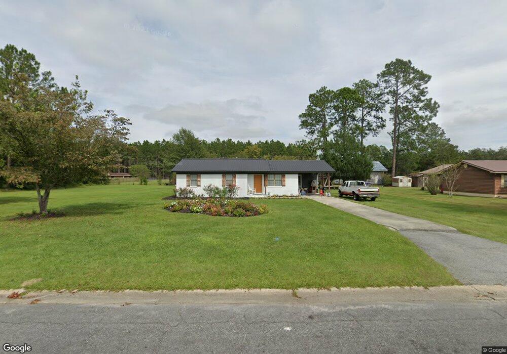
This home is located at 304 Crosby Rd, Alma, GA 31510 and is currently estimated at $114,454, approximately $100 per square foot. 304 Crosby Rd is a home located in Bacon County with nearby schools including Bacon County Primary School, Bacon County Elementary School, and Bacon County Middle School.
Ownership History
Date
Name
Owned For
Owner Type
Purchase Details
Closed on
May 7, 2015
Sold by
Winslow Thomas
Bought by
Miles Tanya
Current Estimated Value
Purchase Details
Closed on
Aug 7, 2014
Sold by
Wells Etta J
Bought by
Winslow Thomas
Create a Home Valuation Report for This Property
The Home Valuation Report is an in-depth analysis detailing your home's value as well as a comparison with similar homes in the area
Home Values in the Area
Average Home Value in this Area
Purchase History
| Date | Buyer | Sale Price | Title Company |
|---|---|---|---|
| Miles Tanya | -- | -- | |
| Winslow Thomas | -- | -- |
Source: Public Records
Tax History Compared to Growth
Tax History
| Year | Tax Paid | Tax Assessment Tax Assessment Total Assessment is a certain percentage of the fair market value that is determined by local assessors to be the total taxable value of land and additions on the property. | Land | Improvement |
|---|---|---|---|---|
| 2024 | $1,097 | $31,640 | $1,880 | $29,760 |
| 2023 | $1,042 | $28,440 | $1,880 | $26,560 |
| 2022 | $709 | $19,800 | $1,880 | $17,920 |
| 2021 | $690 | $19,320 | $1,880 | $17,440 |
| 2020 | $637 | $17,232 | $1,728 | $15,504 |
| 2019 | $637 | $17,232 | $1,728 | $15,504 |
| 2018 | $633 | $17,166 | $1,728 | $15,438 |
| 2017 | $691 | $17,166 | $1,728 | $15,438 |
| 2016 | $691 | $17,166 | $1,728 | $15,438 |
| 2015 | -- | $16,827 | $1,930 | $14,898 |
| 2014 | -- | $16,827 | $1,930 | $14,898 |
| 2013 | -- | $16,967 | $1,929 | $15,037 |
Source: Public Records
Map
Nearby Homes
- 301 Taylor Rd
- 403 S Ware St
- 122 Grace Loop Unit 1
- 118 Grace Loop Unit 1
- 117 Grace Loop Unit 1
- 314 W 16th St
- 9TH E 417
- 0 E 6th St Unit 114222
- 1348 U S 1
- 113 Brite Blue Dr
- 166 Grace Loop Unit 1
- 907 N Pierce St
- 401 Lee St
- 0 Oriole Rd Unit 160930
- 0 Oriole Rd Unit 23852171
- 0 Oriole Rd Unit 1654653
- 0 Oriole Rd Unit 10543585
- 118 Morris Dr
- 245 Starling Rd
- 1109 W 4th Street Extension
- 108 Mccrea Ave
- 305 Crosby Rd
- 308 Crosby Rd
- 303 Crosby Rd
- 202 Mccrea Ave
- 507 Radio Station Rd
- 310 Crosby Rd
- 309 Crosby Rd
- 501 Radio Station Rd
- 109 Mccrea Ave
- 107 Mccrea Ave
- 511 Radio Station Rd
- 207 Crosby Rd
- 506 Townsend Ln
- 0 Townsend Ln
- 405 Radio Station Rd
- 204 Mccrea Ave
- 306 Taylor Rd
- 308 Taylor Rd
- 603 Radio Station Rd